![]()
![]()
![]()
![]()
![]()
![]()


MY MAPS
Regions:
![]()
Browse the website:
Latest Acquisitions
A Brief History of Cartography
The Cartographers
Events on ancient maps
Accimo editions
Brochure MB
Contacts
Glossary
Sitemap
|
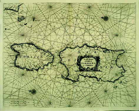
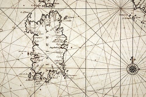
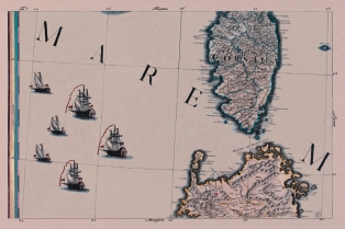
103-Le Coste Marittime delle Isole di Sardegna e Corsica .
The map belongs to the atlas Prima parte dello Specchio del Mare published in 1664 in Genoa by F.M. Levanto. It was taken from a copper plate engraving and proposes a sector of the Mediterranean Sea with Sardinia, Corsica, Elba and other small Islands of the Tuscan Archipelago and the Promontory of Piombino. Author: Francesco Maria Levanto
Genova ,1664 |
|
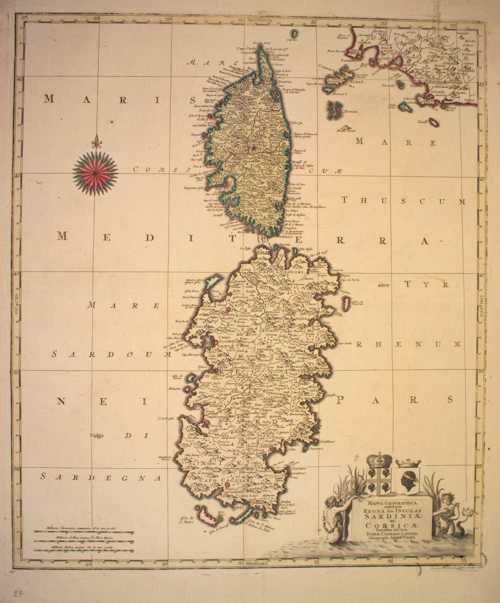
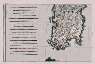
104-Regna Sive Insulas Sardiniae ac Corsicae .
The colored map measures 56,7 x 48,6 cm. It belongs to the Atlas Novus of T.C. Lotter, printed in 1764 in Augsburg. At the top on the right are exposed the islands of the Tuscan Archipelago ,on the left there is a beautiful wind rose and on the right below a decorating picture.
Author: Tobiae Conradi Lotter
Augsburg ,1764 |
|
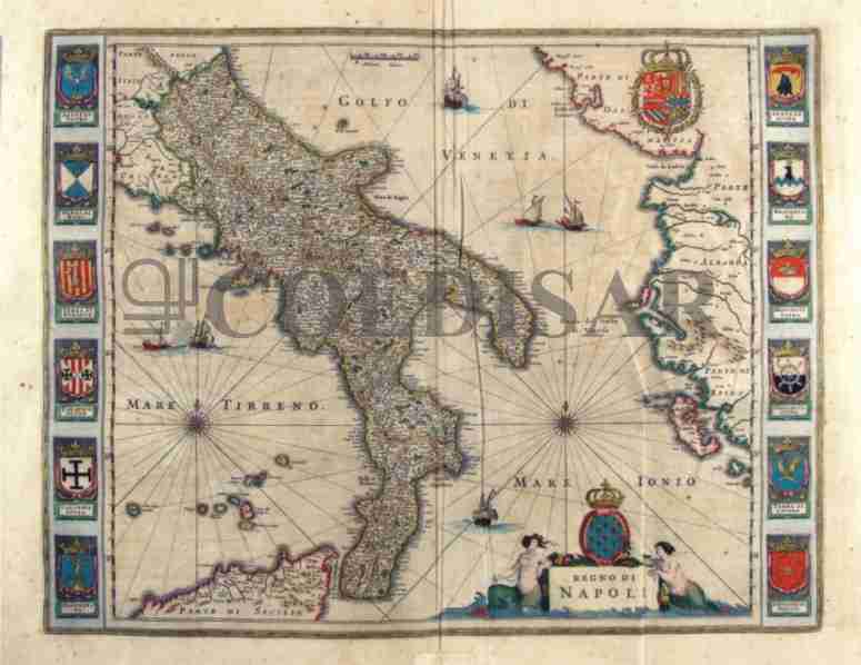
203-Regno di Napoli - Italia .
The Map, that measures the sketch at cm 49,5 xes 38,5, is to be found in the atlas Geographiae Blavianae volume octavum Quo Italy east quae Europae Liber XVI of Blaeu printed in Amsterdam in 1662.
Author: Ioannis Blaeu
Amsterdam ,1662 |
|
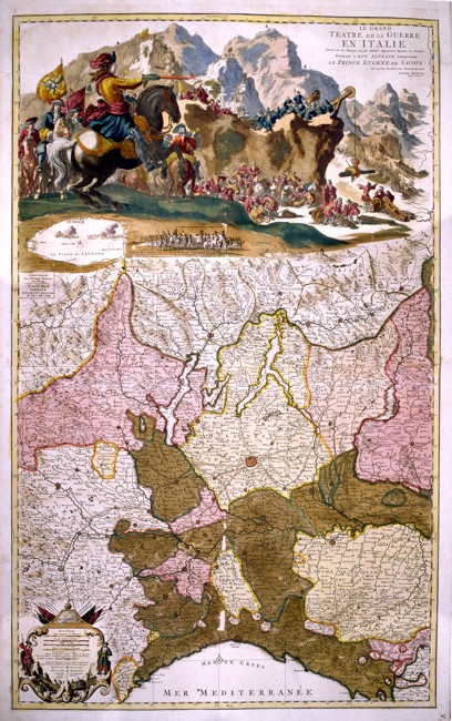
204-Le Grand Theatre de Guerre en Italie .
North Italy, from Liguria to the borders of Switzerland, with Milan in the centre. At the top a coloured picture of war scenes in Cremona shows the entrance of the Prince of Savoy with three thousand men.
The map also includes a fine description of the mountains, of the water courses, of the borders of the states and of the main roads. This splendid vertical map, drawn by the engineers in Eugenio of Savoy’s army, was printed in Amsterdam by Pierre Mortier and measures 97 x 59,5 cm. Author: Pierre Mortier
Amsterdam ,0 |
|
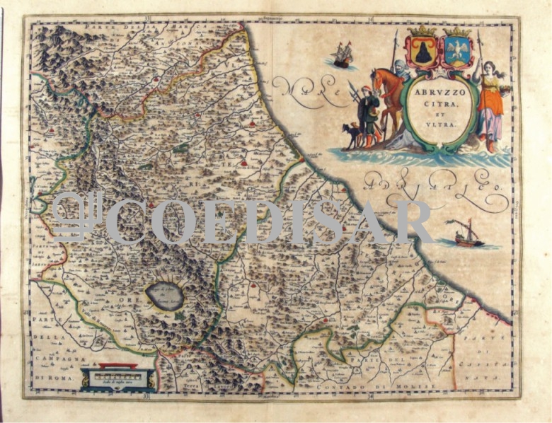
216-Abruzzo citra et ultra - Abruzzo - Italia .
The Charter, which measures cm 49,5 x 38.5 is to be found in Atlas Geographiae Blavianae volume octavum Quo Italy quae est Europae Liber XVI of Blaeu printed in Amsterdam in 1662.
Author: Ioannis Blaeu
Amsterdam. ,1662 |
|
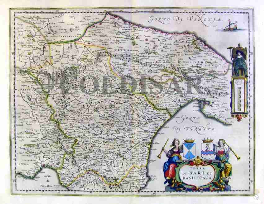
217-Terra di Bari et Basilicata - Italia .
The Charter, which measures cm 50 x 38.5, is to be found in the Atlas Geographiae Blavianae volume octavum Quo Italy quae est Europae Liber XVI of Blaeu printed in Amsterdam in 1662.
Author: Ioannis Blaeu
Amsterdam ,1662 |
|
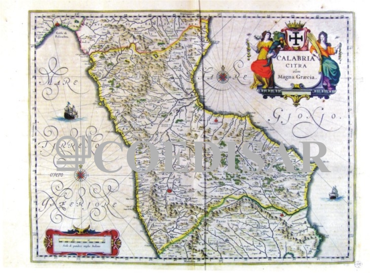
218-Calabria citra olim Magna Graecia - Calabria - Italia .
The Charter, which measures cm 49 x 38, is to be found in the Atlas Geographiae Blavianae volume octavum Quo Italy quae est Europae Liber XVI of Blaeu printed in Amsterdam in 1662.
Author: Ioannis Blaeu
Amsterdam ,1662 |
|
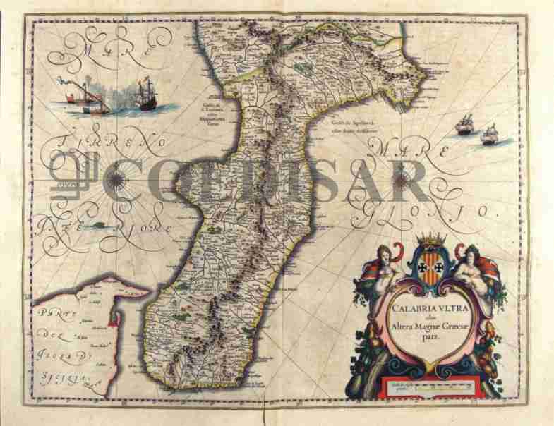
219-Calabria ultra olim Alterae Magnae Graeciae pars - Calabria - Italia .
The Charter, which measures 50.4 x 39 cm, is to be found in the Atlas Geographiae Blavianae volume octavum Quo Italy quae est Europae Liber XVI of Blaeu printed in Amsterdam in 1662 Author: Ioannis Blaeu
Amsterdam ,1662 |
|
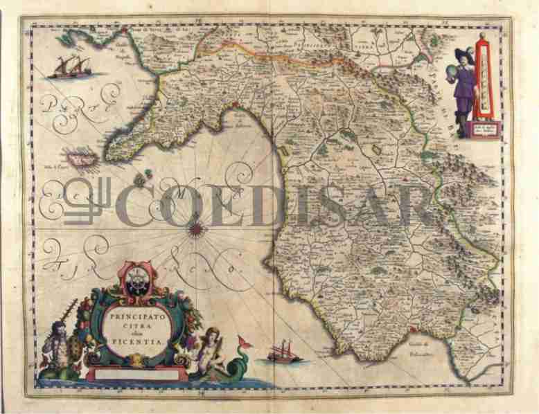
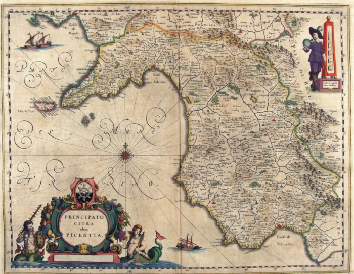
222-Principato Citra olim Picentia - Campania - Italia .
The Charter, which measures 49.2 x 38,5 cm, is to be found in the Atlas Geographiae Blavianae volume octavum Quo Italy quae est Europae Liber XVI of Blaeu printed in Amsterdam in 1662. Author: Ioannis Blaeu
Amsterdam ,1662 |
|
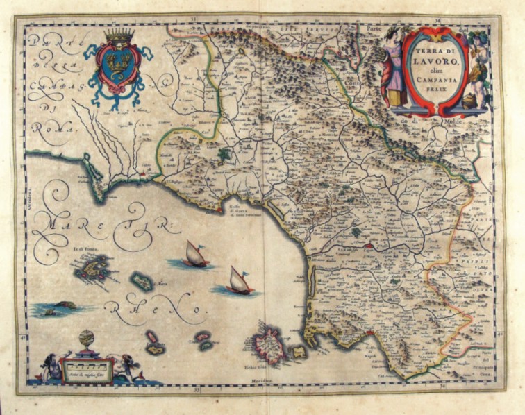
223-Terra di Lavoro olim Campania Felix - Campania - Italia .
The Charter, which measures 48.8 x 38, is to be found in the Atlas Geographiae Blavianae volume octavum Quo Italy quae est Europae Liber XVI of Blaeu printed in Amsterdam in 1662. Author: Ioannis Blaeu
Amsterdam ,1662 |
|
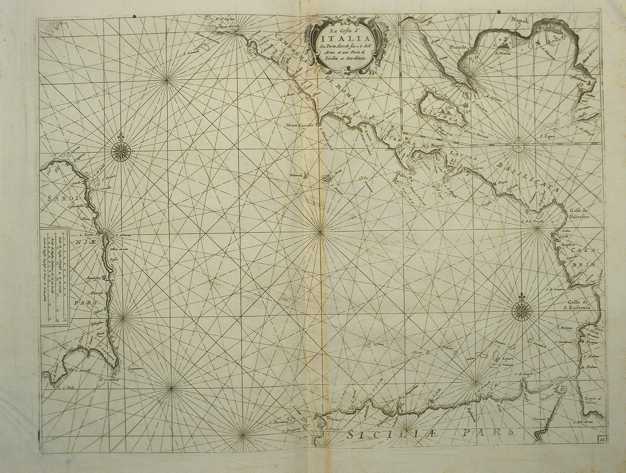
224-La costa d'Italia da Porto Hercole sino a C. dell'Arme .
The map measures 40 x 50,6 cm and belongs to the atlas Prima parte dello Specchio del Mare, published in 1664 in Genoa by F.M. Levanto. It offers an exhaustive view of the South Thyrrenian Sea. Author: Francesco Maria Levanto
Genova ,0 |
|
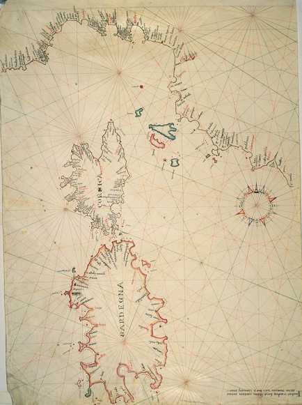
225-Thyrrenian Sea .
The map measures 46,5 x 65,6 cm and represents a large part of the Thyrrenian Sea. Down on the right are reported the author's name, the place and the date of the map's redaction: Iacobus Maiolus fecit cartam Genue anno domini 1567 diem ianuarii XXX. Further on the right we can see a very beautiful wind rose from which depart 32 directions crossing in 9 different points. It's a typical nautical chart, very beatiful even if very schematic. It shows the coast profil and gives a lot of interesting informations for the navigation. There is no description of the inside area.
Author: Jacobus Maiolus
Genova ,1567 |
|
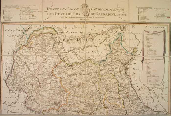
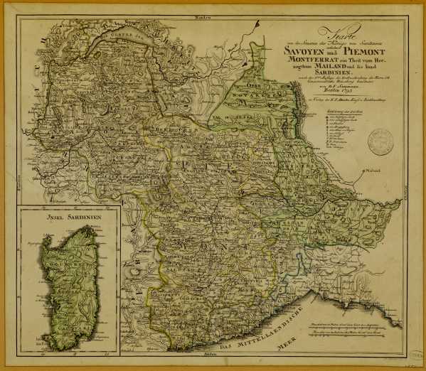
226-New chorographic map of the Sardinian's Empire States .
The map, printed in 1793, measures 74 x 69 cm and is on scale 1:500 000. It exposes Savoy, the Aosta Valley and a sector of the Piedmont. Author: J. B. Bouge
Berlino ,1793 |
|
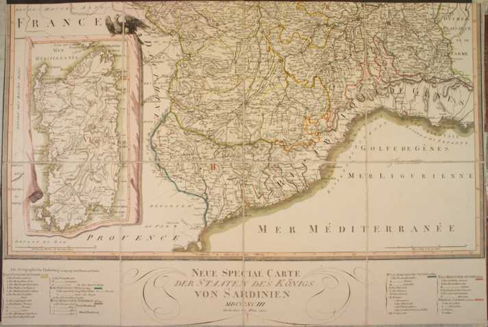
227-New special map of the Sardinia's States .
The map, printed in 1793, measures 74 x 69 cm and shows Liguria with a sector of the South Piedmont. Sardinia is exposed in a square. Author: J. B. Bouge
,1793 |
|
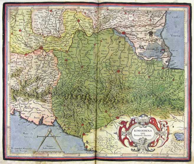
228-Romandiola - Italia .
The map belongs to the Atlas sive Cosmographicae Meditationes de Fabrica Mundi et Fabricati Figura, published in 1644 in Duisburg.
Dimensions: cm 44 X 37 Author: Gerardo Mercatore
Duisburg ,1644 |
|
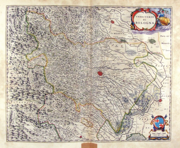
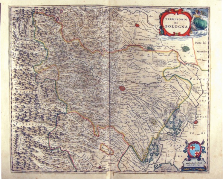
230-Territorio di Bologna - Emilia Romagna - Italia .
The Charter, which measures ' 53.4 x 44 is located in the Atlas Theatrum Orbis Terrarum sive Atlas Novus-tertia pars of Guilelmus et Ioannis Blaeu, printed in Amsterdam in the workshop of Giovanni Blaeu in 1650. Offers Emilia, Appennines until Polesine and, to the North, the city of Modena Author: Ioannis Blaeu
Amsterdam ,1650 |
|
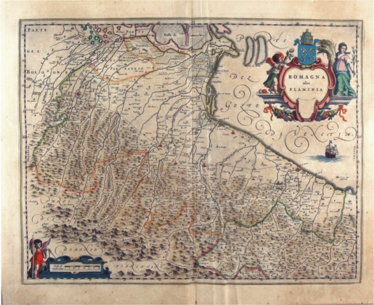
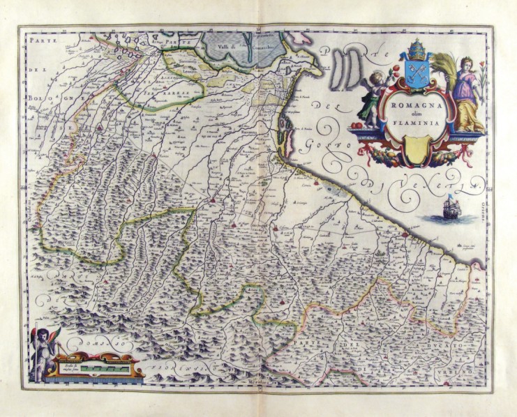
231-Romagna olim Flaminia - Emilia Romagna - Italia .
The Charter, which measures ' 49.2 x 38 is located in the Atlas Theatrum Orbis Terrarum sive Atlas Novus-tertia pars of Guilelmus et Ioannis Blaeu, printed in Amsterdam in the workshop of Giovanni Blaeu in 1650. The card offers the Romagna, from Imola to West to the Adriatic coast of Rimini Author: Ioannis Blaeu
Amsterdam ,1650 |
|
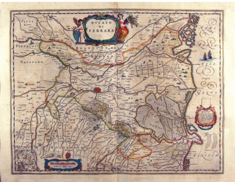
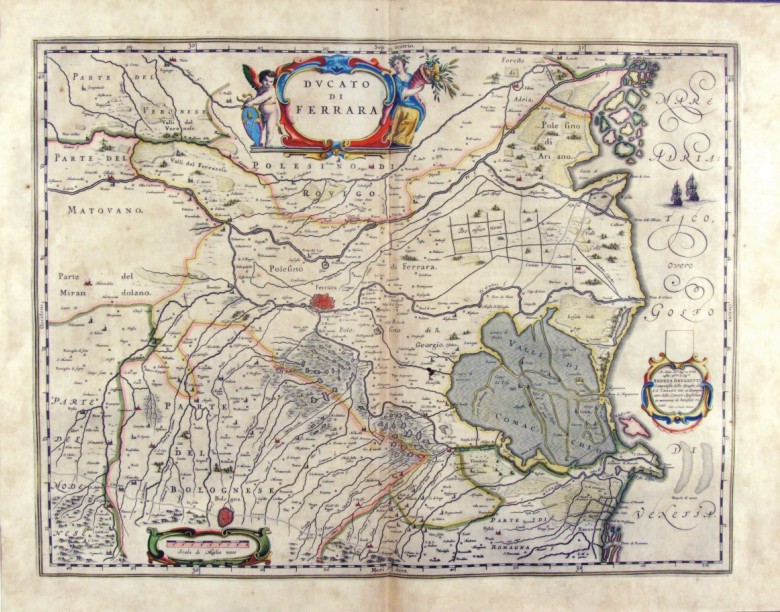
232-Ducato di Ferrara - Emilia Romagna - Italia .
The card, measuring 49.7 x 38 cm is located in the Atlas Theatrum Orbis Terrarum sive Atlas Novus pars Tertia is to Guilelmus et Ioannis Blaeu, printed in Amsterdam in the workshop of Giovanni Blaeu in 1650. The paper proposes the Polesine Ferrara with its surroundings and the lagoons of Comacchio Valley and is of considerable historical importance because it suggests the limits of many territories and possessions. In the lower right is shown a dedication and Jhoannem Cornelium Blaeu Andrea Brugiotti. Author: Ioannis Blaeu
Amsterdam ,1650 |
|
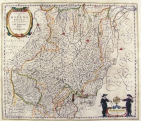
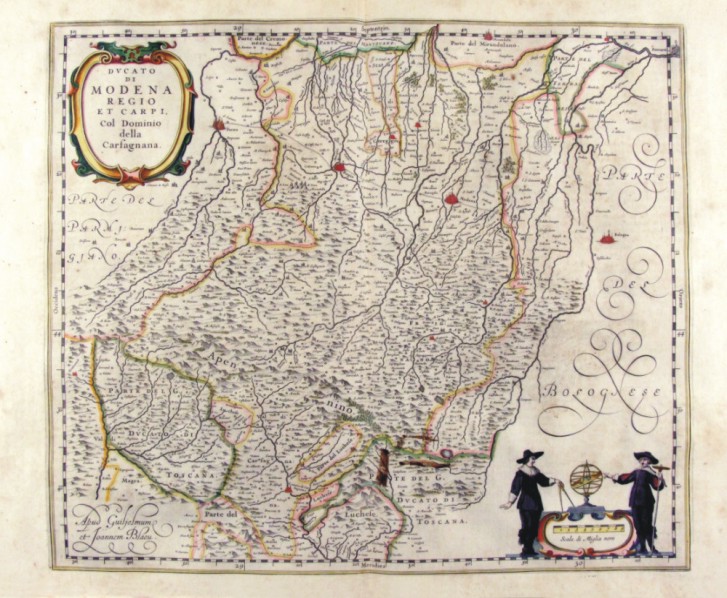
233-Ducato di Modena Reggio et Carpi - Emilia Romagna - Italia .
The paper, which measures 47 x 40 cm is located in the Atlas Theatrum Orbis Terrarum sive Atlas Novus - tertia pars of Guilelmus et Ioannis Blaeu, printed in Amsterdam in the workshop of Giovanni Blaeu in 1650. The paper proposes the area of the Po valley bordering the Apennines and is enriched by two scrolls, the first of which, at the top contains the title, while the bottom right, contains the metric scale and is adorned with the figures of two geographers Author: Ioannis Blaeu
Amsterdam ,1650 |
|
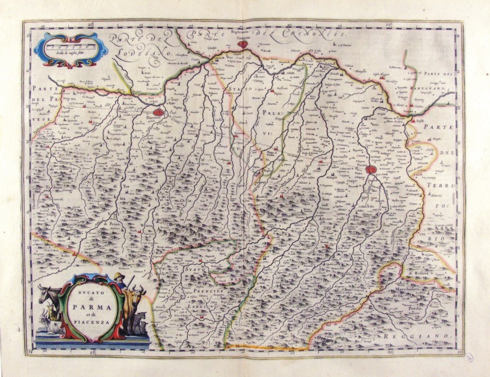
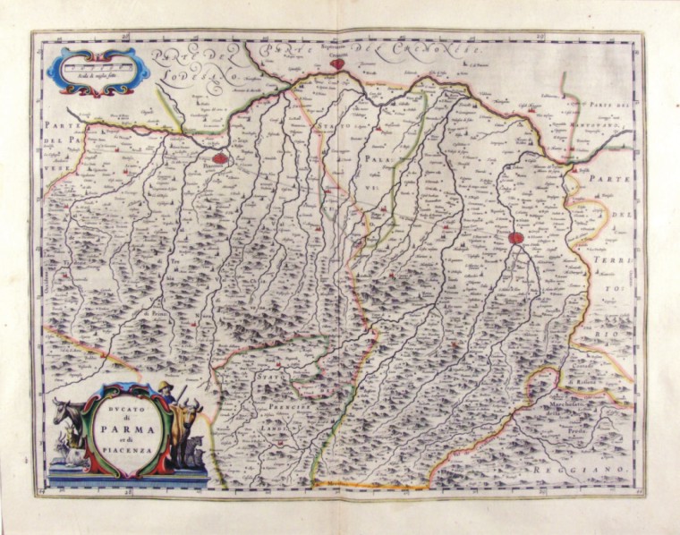
234-Ducato di Parma et di Piacenza - Emilia Romagna - Italia .
The paper, which measures 50 x 38 cm is located in the Atlas Theatrum Orbis Terrarum sive Atlas Novus - tertia pars of Guilelmus et Ioannis Blaeu, printed in Amsterdam in the workshop of Giovanni Blaeu in 1650. The paper proposes the territory of the ancient Duchy enclosing a part of the Po Valley and the northern sector of the Apennines.
Author: Ioannis Blaeu
Amsterdam ,1650 |
|
235-Ducato di Modena Reggio et Carpi - Emilia Romagna - Italia .
The card, measuring 46.7 x 40.5 cm in the drawing is contained in the atlas Geographiae Blavianae volumen octavum Quo Italy quae est Europae Liber XVI Blaeu printed in Amsterdam in 1662. Author: Ioannis Blaeu
Amsterdam ,1662 |
|
236-Ducato di Parma et di Piacenza - Emilia Romagna - Italia .
The paper, which measures 50 x 38.5 cm in design, is contained in the atlas Geographiae Blavianae volumen octavum Quo Italy quae est Europae Liber XVI Blaeu printed in Amsterdam in 1662. Author: Ioannis Blaeu
Amsterdam ,1662 |
|
237-Ducato di Ferrara - Emilia Romagna - Italia .
The paper, which measures 50 x 38.5 cm in design, is contained in the atlas Geographiae Blavianae volumen octavum Quo Italy quae est Europae Liber XVI Blaeu printed in Amsterdam in 1662. Author: Ioannis Blaeu
Amsterdam ,1662 |
|
238-Territorio di Bologna - Emilia Romagna - Italia .
The paper, which measures 53 x 44 cm in the design, is contained in the atlas Geographiae Blavianae volumen octavum Quo Italy quae est Europae Liber XVI Blaeu printed in Amsterdam in 1662.
Author: Ioannis Blaeu
Amsterdam ,1662 |
|
239-Romagna olim Flaminia - Emilia Romagna - Italia .
The Charter, which measures in the drawing cm 49 x 38, is contained in the Atlas Geographiae Blavianae volumen octavum Quo Italy quae est Europae Liber XVI of Blaeu printed in Amsterdam in 1662 Author: Ioannis Blaeu
Amsterdam ,1662 |
|
240-Friuli Venezia Giulia , Istria - Italia .
The map belongs to the Atlas sive Cosmographicae Meditationes de Fabrica Mundi et Fabricati Figura, published in 1644 in Duisburg.
Author: Gerardo Mercatore
Duisburg ,1644 |
|
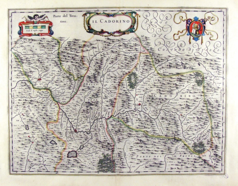
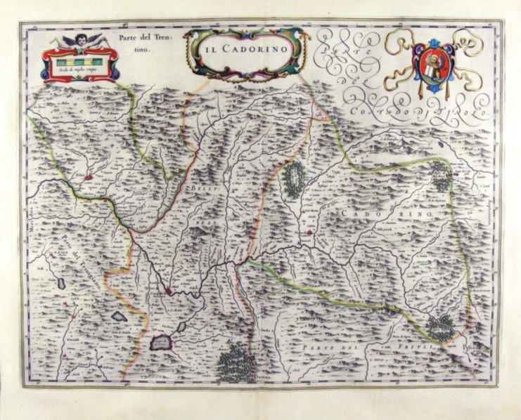
241-Il Cadorino - Friuli Venezia Giulia - Italia .
The Charter, which measures ' 49,7 x 38 is located in the Atlas Theatrum Orbis Terrarum sive Atlas Novus-tertia pars of Guilelmus et Ioannis Blaeu, printed in Amsterdam in the workshop of Giovanni Blaeu in 1650. The Charter represents the northern sector of Friuli, which borders the Tyrol.
Author: Ioannis Blaeu
Amsterdam ,1650 |
|
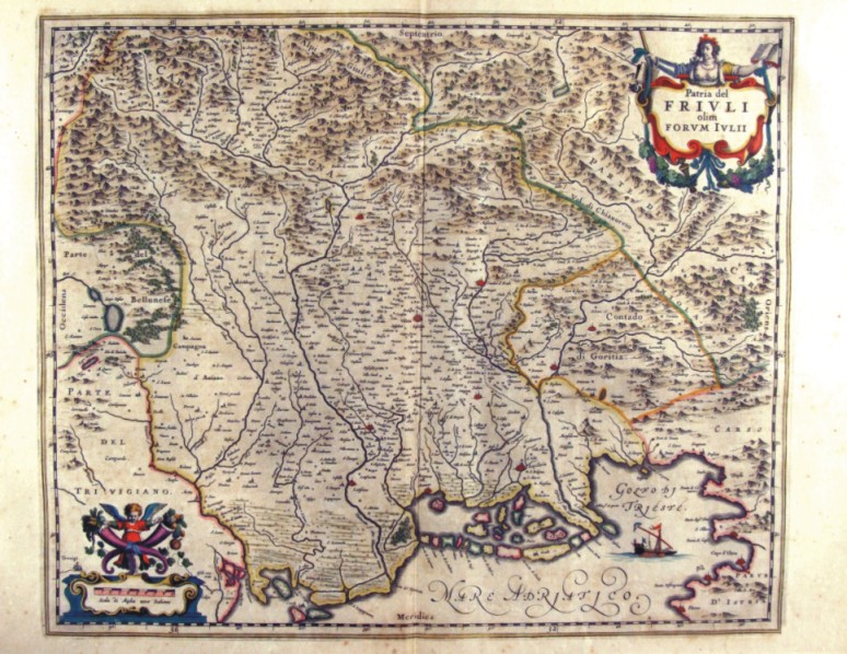
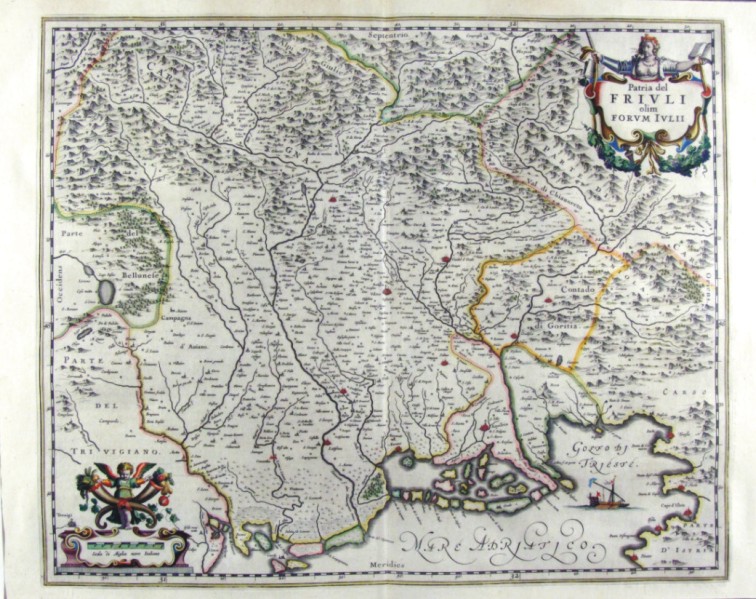
242-Patria del Friuli - Friuli Venezia Giulia - Italia .
The Charter, which measures ' 49,7 x 41 is located in the Atlas Theatrum Orbis Terrarum sive Atlas Novus-tertia pars of Guilelmus et Ioannis Blaeu, printed in Amsterdam in the workshop of Giovanni Blaeu in 1650. The card offers the North Eastern region of Italy between the Bellunese and karst with The countryside of Gorizia, part of Treviso, Trieste and its Gulf.
Author: Ioannis Blaeu
Amsterdam ,1650 |
|
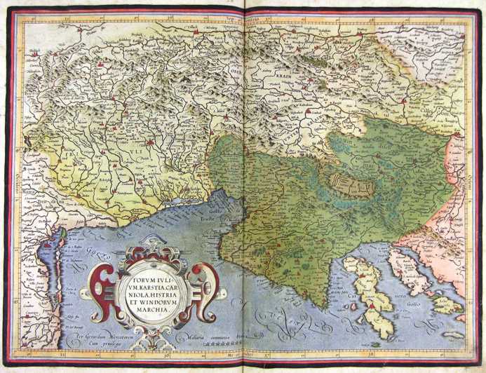
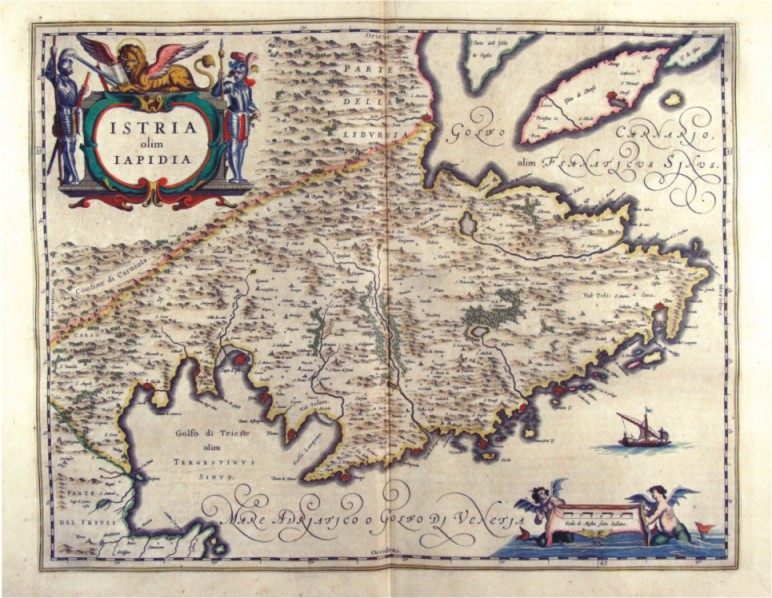
243-Istria olim Iapidia - Friuli Venezia Giulia - Italia .
The Charter, which measures ' 49,7 x 38 is located in the Atlas Theatrum Orbis Terrarum sive Atlas Novus-tertia pars of Guilelmus et Ioannis Blaeu, printed in Amsterdam in the workshop of Giovanni Blaeu in 1650. The Charter represents Istria with the Trieste Gulf to the West and the Gulf of Carnaro to East, with the town of Pula.
Author: Ioannis Blaeu
Amsterdam ,1650 |
|
244-Patria del Friuli - Friuli Venezia Giulia - Italia .
The Charter, which measures in the drawing ' 49.6 x 41 is contained in the Atlas Geographiae Blavianae volumen octavum Quo Italy quae est Europae Liber XVI of Blaeu printed in Amsterdam in 1662.
Author: Ioannis Blaeu
Amsterdam ,1662 |
|
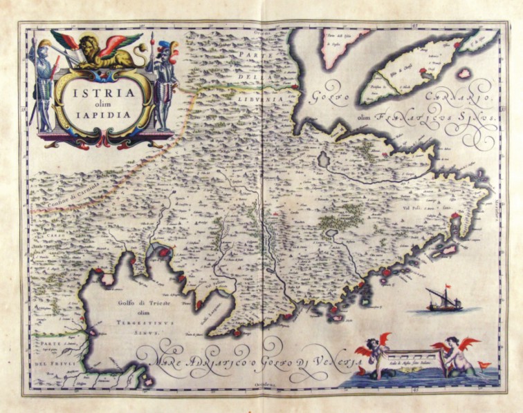
245-Istria olim Iapidia - Friuli Venezia Giulia - Italia .
The Charter, which measures in the drawing cm 49,5 x 38.5, is contained in the Atlas Geographiae Blavianae volumen octavum Quo Italy quae est Europae Liber XVI of Blaeu printed in Amsterdam in 1662.
Author: Ioannis Blaeu
Amsterdam ,1662 |
|
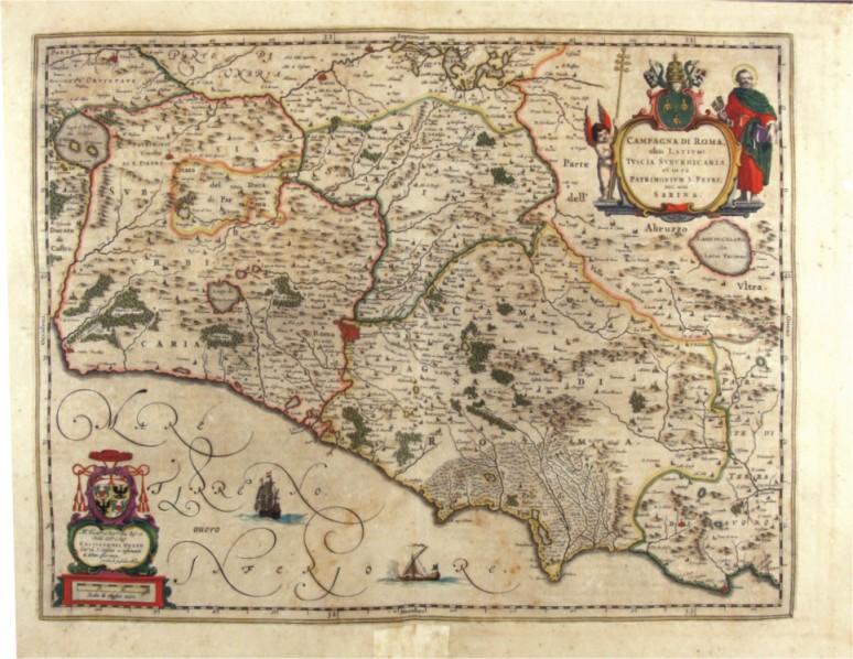
247-Campagna di Roma - Lazio - Italia .
The Charter, which measures in the drawing cm 50 x 39, is contained in the Atlas Geographiae Blavianae volumen octavum Quo Italy quae est Europae Liber XVI of Blaeu printed in Amsterdam in 1662.
Author: Ioannis Blaeu
Amsterdam ,1662 |
|
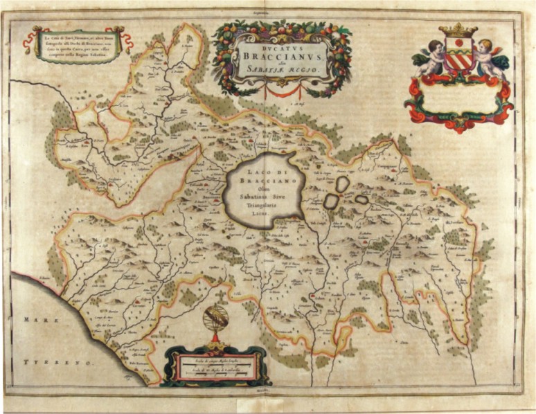
248-Ducatus Braccianus - Lazio - Italia .
The Charter, which measures in the drawing 56.4 x 42 cm, is contained in the Atlas Geographiae Blavianae volumen octavum Quo Italy quae est Europae Liber XVI of Blaeu printed in Amsterdam in 1662.
Author: Ioannis Blaeu
Amsterdam ,1662 |
|
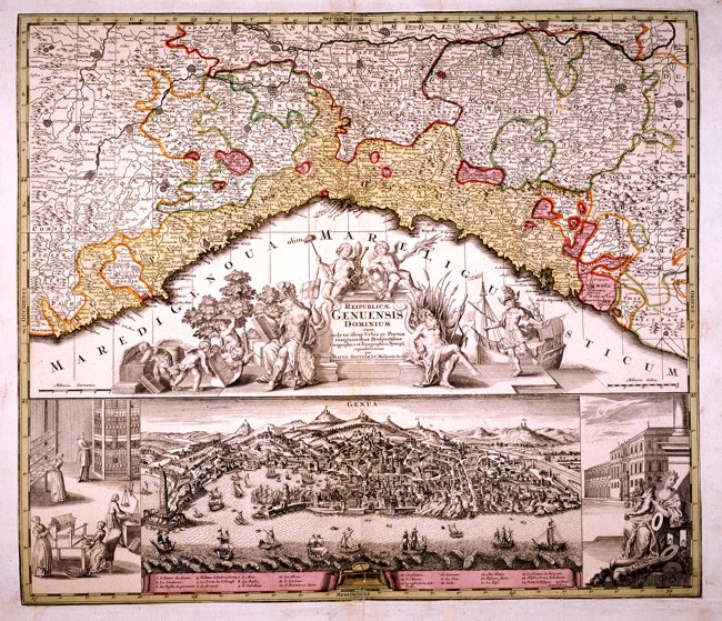
Republicae Genuensis Dominium .
Liguria from Ventimiglia in the West to the Dukedom of Massa in the East. There is a very beautiful title picture in the centre and a splendid drawing of the town of Genoa at the bottom. This well-drawn map is an interesting geographical and historical document and measures 56,8 x 49 cm. Author: Seutter Matteo
Augusta ,1740 |
|
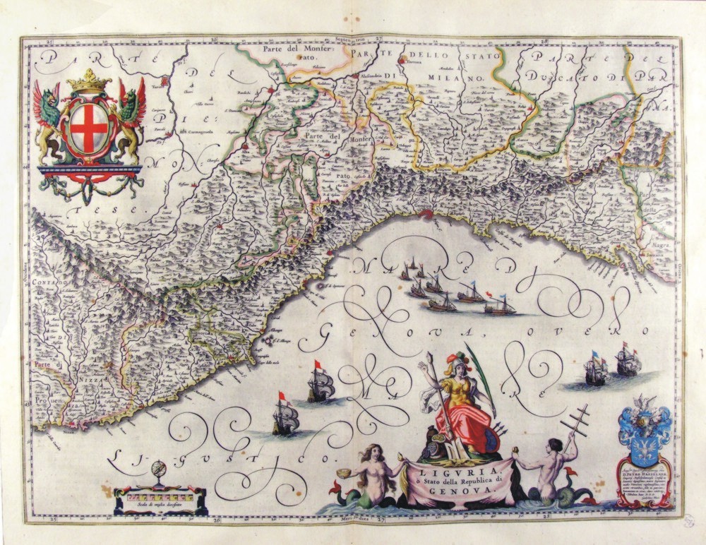
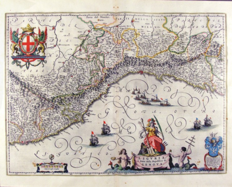
250-Liguria o Stato della Repubblica di Genova - Liguria - Italia .
The Charter, which measures ' 50.5 x 37.5 is located in the Atlas Theatrum Orbis Terrarum sive Atlas Novus-tertia pars of Guilelmus et Ioannis Blaeu, printed in Amsterdam in the workshop of Giovanni Blaeu in 1650. Charter graphically pleasing enriched by l±d and drawing with a large number of vessels sailing in the Gulf of Genoa. Liguria is surrounded by a circle montano and North is a part of Monferrato and the rule of Milan.
Author: Ioannis Blaeu
Amsterdam ,1650 |
|
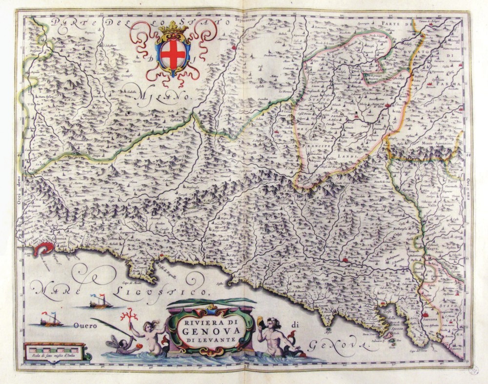
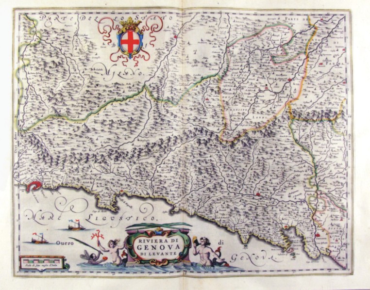
252-Riviera di Genova di Levante - Liguria - Italia .
The Charter, that measure cm 49 x 39 is located in the Atlas Theatrum Orbis Terrarum sive Atlas Novus-tertia pars of Guilelmus et Ioannis Blaeu, printed in Amsterdam in the workshop of Giovanni Blaeu in 1650. Charter graphically pleasing that offers Liguria Eastern scale greater than the previous, the Southern Piedmont. The title is contained in a nice title block adorned by mythological figures. A nice lable top offers the cross of the Republic of Genoa. Author: Ioannis Blaeu
Amsterdam ,1650 |
|
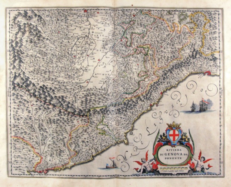
253-Riviera di Genova di Ponente - Liguria - Italia .
The Charter, which measures ' 48.7 x 38 is located in the Atlas Theatrum Orbis Terrarum sive Atlas Novus-tertia pars of Guilelmus et Ioannis Blaeu, printed in Amsterdam in the workshop of Giovanni Blaeu in 1650. Charter graphically pleasing that offers the western Liguria to larger scale than the previous, Piedmont meridioneale. The title is contained in a nice lable. Author: Ioannis Blaeu
Amsterdam ,1650 |
|
254-Riviera di Genova di Ponente - Liguria - Italia .
The Charter, that measure cm 49 x 38, is contained in the Atlas Geographiae Blavianae volumen octavum Quo Italy quae est Europae Liber XVI of Blaeu printed in Amsterdam in 1662. Charter graphically pleasing that offers the western Liguria to larger scale than the previous, Piedmont meridioneale. The title is contained in a nice lable. Author: Ioannis Blaeu
Amsterdam ,1662 |
|
255-Riviera di Genova di Levante - Liguria - Italia .
The Charter, that measure cm 49 x 39, is contained in the Atlas Geographiae Blavianae volumen octavum Quo Italy quae est Europae Liber XVI of Blaeu printed in Amsterdam in 1662. Charter graphically pleasing that offers Liguria Eastern from Genoa up in Sarzana. The title is contained in a nice title block adorned by mythological figures. A nice lable top offers the cross of the Republic of Genoa. Author: Ioannis Blaeu
Amsterdam ,1662 |
|
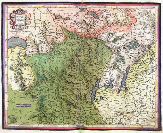
256-Lombardia - Italia .
The map belongs to the Atlas sive Cosmographicae Meditationes de Fabrica Mundi et Fabricati Figura, published in 1644 in Duisburg. Author: Gerardo Mercatore
Duisburg ,1644 |
|
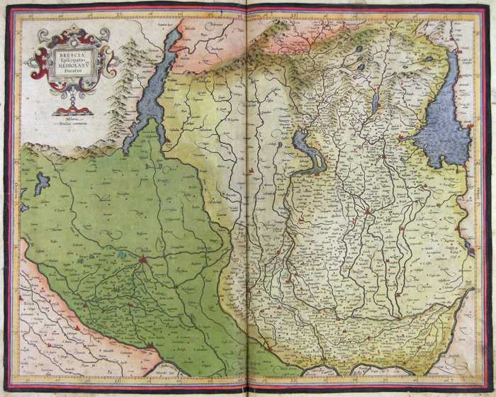
258-Brescia e Milano - Lombardia - Italia .
The map belongs to the Atlas sive Cosmographicae Meditationes de Fabrica Mundi et Fabricati Figura, published in 1644 in Duisburg.
Author: Gerardo Mercatore
Duisburg ,1644 |

|
257-Lombardia e Veneto - Italia .
The map belongs to the Atlas sive Cosmographicae Meditationes de Fabrica Mundi et Fabricati Figura, published in 1644 in Duisburg. Author: Gerardo Mercatore
Duisburg ,1644 |
|
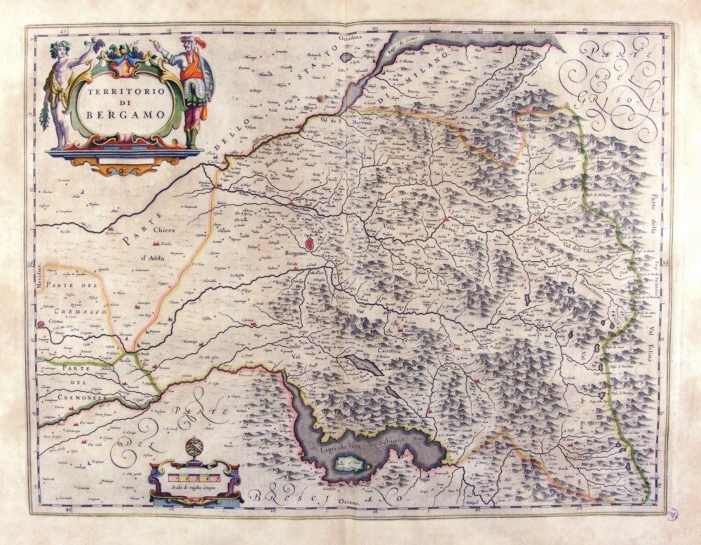
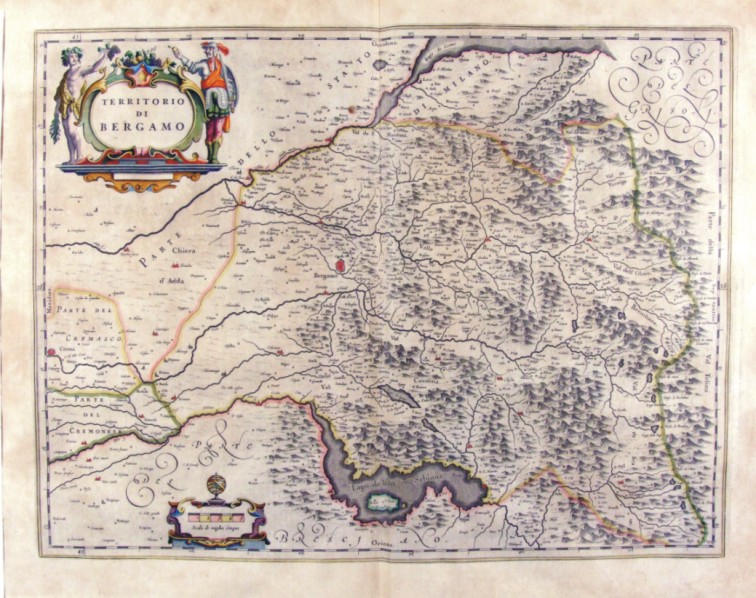
260-Territorio di Bergamo - Lombardia - Italia .
The map measures 50 x 38 cm and belongs to the atlas Theatrum Orbis Terrarum sive Atlas Novus - pars tertia - Guilelmus et Ioannis Blaeu, printed in 1650 in the Blaeu's family workshop in Amsterdam. Author: Ioannis Blaeu
Amsterdam ,1650 |
|
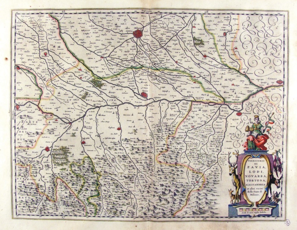
261-Territorio di Pavia, Lodi, Novarra, Tortona e Alessandria - Lombardia - Italia .
The Charter, to what extent 50.5 x 38,5 cm is located in the Atlas Theatrum Orbis Terrarum sive Atlas Novus is tertia pars of Guilelmus et Ioannis Blaeu, printed in Amsterdam in the workshop of Giovanni Blaeu in 1650. The card offers the Po Valley from Casale in Cremona. Author: Ioannis Blaeu
Amsterdam ,1650 |
|
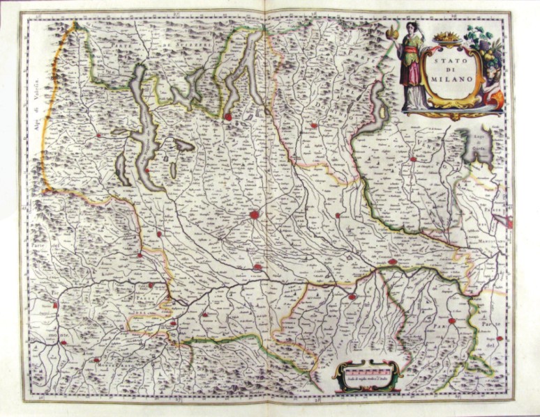
262-Stato di Milano - Lombardia - Italia .
The Charter, to what extent 52.3 x 41.5 cm is located in the Atlas Theatrum Orbis Terrarum sive Atlas Novus-tertia pars of Guilelmus et Ioannis Blaeu, printed in Amsterdam in the workshop of Giovanni Blaeu in 1650. The card offers the Lombardia Author: Ioannis Blaeu
Amsterdam,1650 |
|
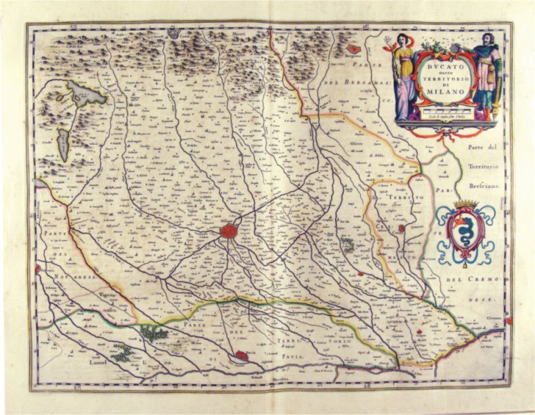
263-Ducato ovvero Territorio di Milano - Lombardia - Italia .
The Charter, to what extent 50.5 x 38,5 cm is located in the Atlas Theatrum Orbis Terrarum sive Atlas Novus-tertia pars of Guilelmus et Ioannis Blaeu, printed in Amsterdam in the workshop of Giovanni Blaeu in 1650. The Charter represents Milan and its territory and is adorned by two Scrolls one of which contains the title and the other the biscione. Author: Ioannis Blaeu
Amsterdam ,1650 |
|
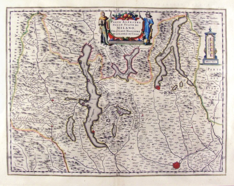
264-Parte Alpestre dello Stato di Milano - Lombardia - Italia .
The Charter, to what extent 50.5 x 38,5 cm is located in the Atlas Theatrum Orbis Terrarum sive Atlas Novus-tertia pars of Guilelmus et Ioannis Blaeu, printed in Amsterdam in the workshop of Giovanni Blaeu in 1650. The Charter represents the Northern Lombardy with the Alps and lakes. Author: Ioannis Blaeu
Amsterdam ,1650 |
|
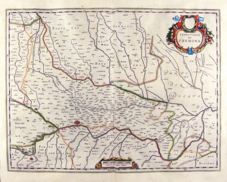
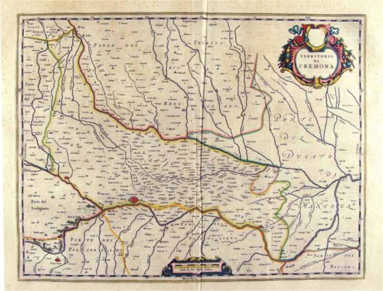
265-Territorio di Cremona - Lombardia - Italia .
The Charter, that measure cm 50 x 38 is located in the Atlas Theatrum Orbis Terrarum sive Atlas Novus-tertia pars of Guilelmus et Ioannis Blaeu, printed in Amsterdam in the workshop of Giovanni Blaeu in 1650. The card offers the Po Valley in the area of Cremona that extends from the Lodgiano to Duchy of Mantovena with a part of the Duchy of Mantova. Author: Ioannis Blaeu
Amsterdam ,1650 |
|
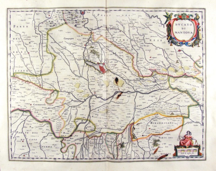
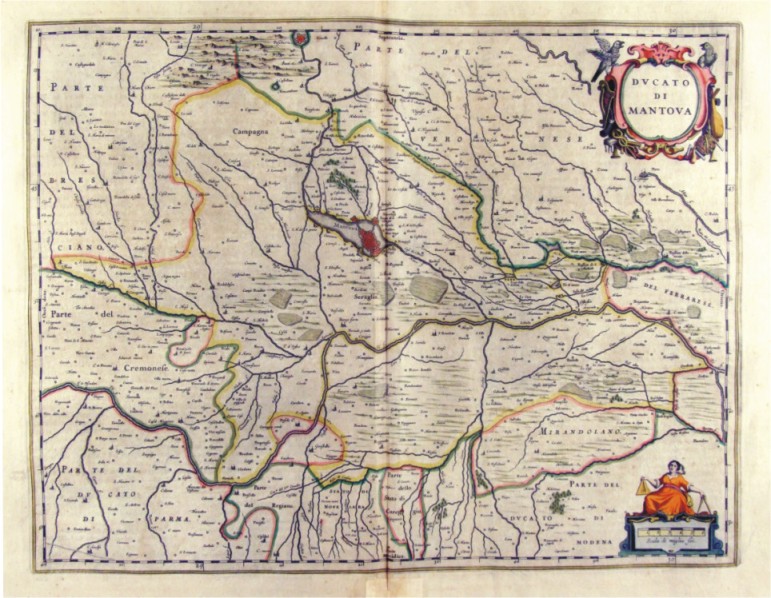
266-Ducato di Mantova - Lombardia - Italia .
The Charter, that measure cm 49 x 38 is located in the Atlas Theatrum Orbis Terrarum sive Atlas Novus-tertia pars of Guilelmus et Ioannis Blaeu, printed in Amsterdam in the workshop of Giovanni Blaeu in 1650. The card offers the Po Valley in the area of Mantova until Ferrarese. Author: Ioannis Blaeu
Amsterdam ,1650 |
|
267-Territorio di Cremona - Lombardia - Italia .
The Charter, to what extent in 38 x 23.4 cm drawing is contained in the Atlas Geographiae Blavianae volumen octavum Quo Italy quae est Europae Liber XVI of Blaeu printed in Amsterdam in 1662. Author: Ioannis Blaeu
Amsterdam,1662 |
|
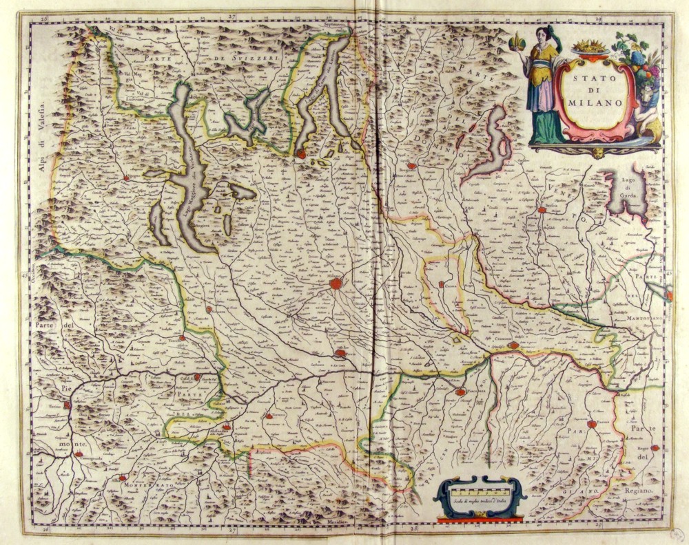
268-Stato di Milano - Lombardia - Italia .
The Charter, which measures in the drawing cm 52 x 41.5 is contained in the Atlas Geographiae Blavianae volumen octavum Quo Italy quae est Europae Liber XVI of Blaeu printed in Amsterdam in 1662. The Charter, whose title is contained in a lable place above right, decorated with figures rappresennati abundance of agricultural products, offers the Lombardy Alps, lakes and southern Switzerland. Author: Ioannis Blaeu
Amsterdam,1662 |
|
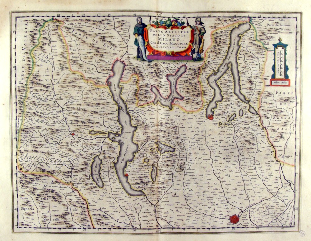
269-Parte Alpestre dello Stato di Milano - Lombardia - Italia .
The Charter, which measures in the drawing 50.5 x 38,5 cm is contained in the Atlas Geographiae Blavianae volumen octavum Quo Italy quae est Europae Liber XVI of Blaeu printed in Amsterdam in 1662. The Charter represents the Northern Milan Lombardy with the bass and the Alps and lakes in the Centre. The title is contained in a lable supported by two men and topped with a copious quantities of agricultural products Author: Ioannis Blaeu
Amsterdam,1662 |
|
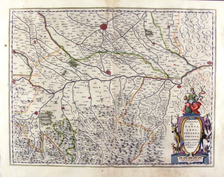
270-Territorio di Pavia, Lodi, Novarra, Tortona e Alessandria - Lombardia - Italia .
The Charter, which measures in the drawing 50.2 x 38,5 cm is contained in the Atlas Geographiae Blavianae volumen octavum Quo Italy quae est Europae Liber XVI of Blaeu printed in Amsterdam in 1662. The card offers the Po Valley from Casale in Cremona with Milan top and Alexandria in the lower right. The paper is crossed by the river Po and its tributaries and is decorated according to the right by a scroll bearing the title. Author: Ioannis Blaeu
Amsterdam,1662 |
|
271-Territorio di Cremona - Lombardia - Italia .
The Charter, which measures in the drawing 50.2 x 38,5 cm is contained in the Atlas Geographiae Blavianae volumen octavum Quo Italy quae est Europae Liber XVI of Blaeu printed in Amsterdam in 1662. The card offers the Po Valley in the area of Cremona that extends from the Lodigiano to Duchy of Mantova Author: Ioannis Blaeu
Amsterdam,1662 |
|
272-Ducato di Mantova - Lombardia - Italia .
The Charter, which measures in cm 50 x 38.5 drawing is contained in the Atlas Geographiae Blavianae volumen octavum Quo Italy quae est Europae Liber XVI of Blaeu printed in Amsterdam in 1662. Author: Ioannis Blaeu
Amsterdam,1662 |
|
273-Territorio di Bergamo - Lombardia - Italia .
The Charter, which measures in cm 50 x 38.5 drawing is contained in the Atlas Geographiae Blavianae volumen octavum Quo Italy quae est Europae Liber XVI of Blaeu printed in Amsterdam in 1662. Author: Ioannis Blaeu
Amsterdam,1662 |
|
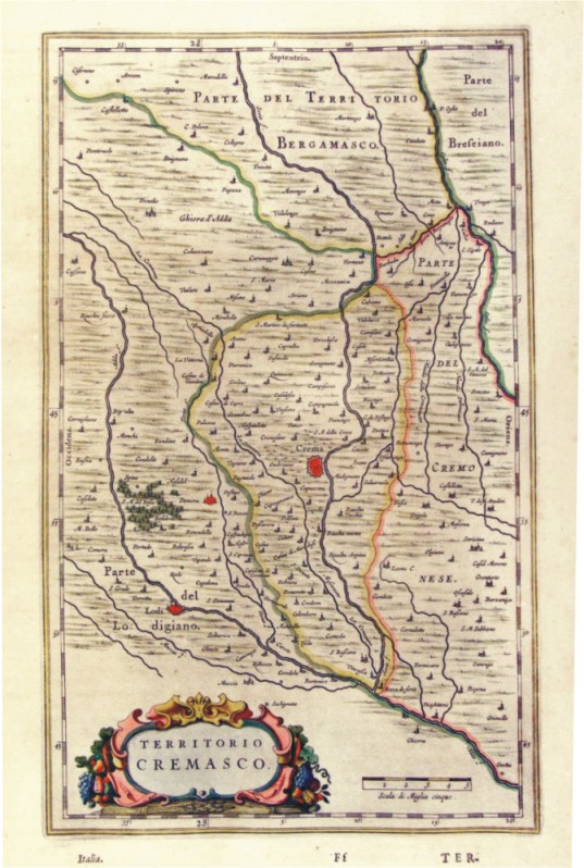
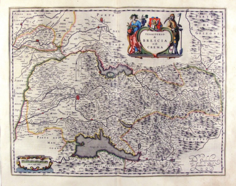
274-Territorio di Brescia et di Crema - Lombardia - Italia .
The Charter, which measures in cm 50 x 38.5 drawing is contained in the Atlas Geographiae Blavianae volumen octavum Quo Italy quae est Europae Liber XVI of Blaeu printed in Amsterdam in 1662. Author: Ioannis Blaeu
Amsterdam,1662 |
|
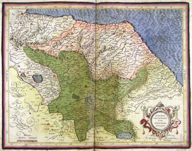
275-Marche, Umbria e Abruzzo - Italia .
The map belongs to the Atlas sive Cosmographicae Meditationes de Fabrica Mundi et Fabricati Figura, published in 1644 in Duisburg.
Author: Gerardo Mercatore
Duisburg ,1644 |
|
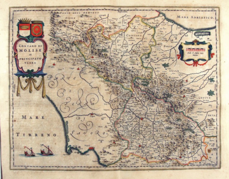
280-Contado di Molise et Principato ultra - Molise - Italia .
The Charter, which measures in the drawing ' 49.2 x 38, is contained in the Atlas Geographiae Blavianae volumen octavum Quo Italy quae est Europae Liber XVI of Blaeu printed in Amsterdam in 1662. Author: Ioannis Blaeu
Amsterdam,1662 |
|
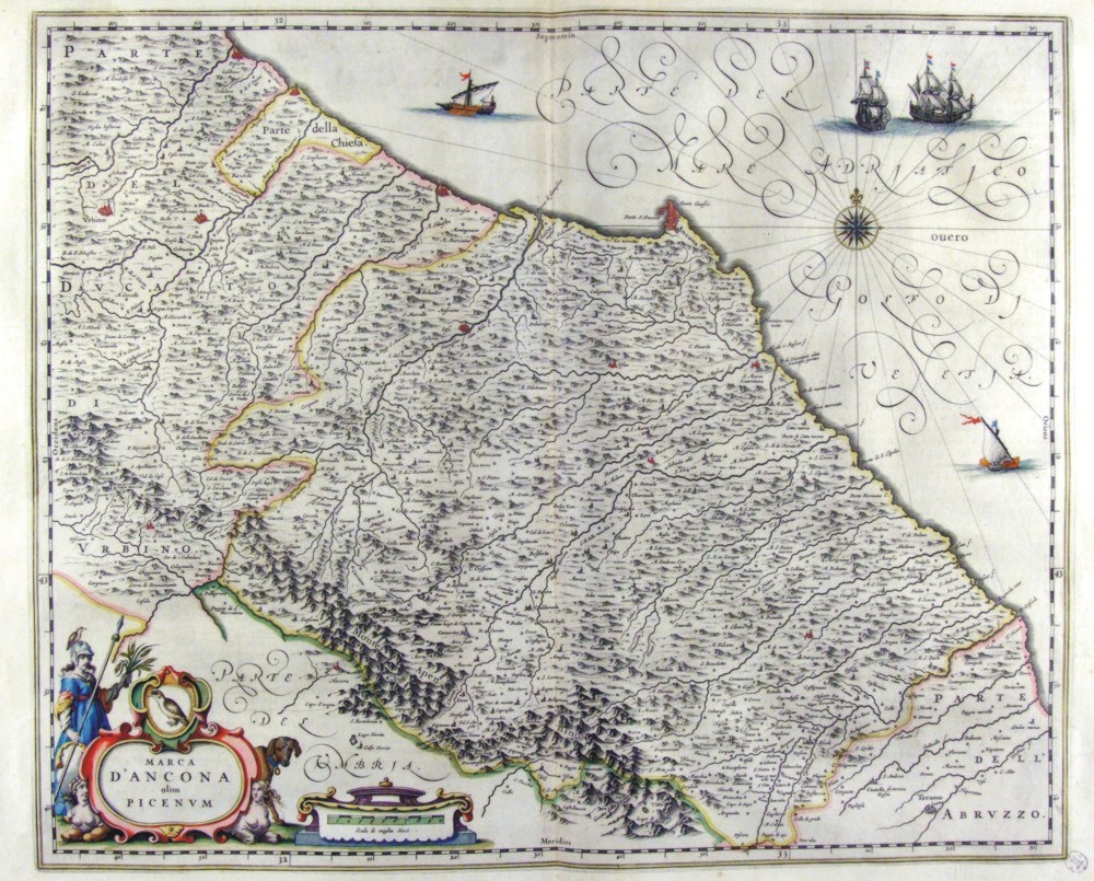
276-Marca d'Ancona olim Picenum - Marche - Italia .
The Charter, that measure cm 50 x 41 is located in the Atlas Theatrum Orbis Terrarum sive Atlas Novus-tertia pars of Guilelmus et Ioannis Blaeu, printed in Amsterdam in the workshop of Giovanni Blaeu in 1650. Author: Ioannis Blaeu
Amsterdam,1650 |
|
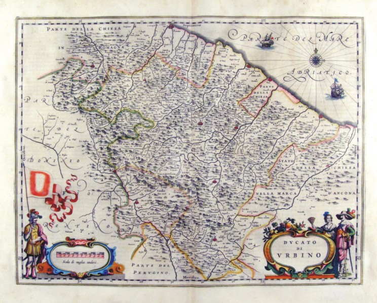
278-Ducato di Urbino - Marche - Italia .
The Charter, which measures in the drawing cm 49,5 x 38 is contained in the Atlas Geographiae Blavianae volumen octavum Quo Italy quae est Europae Liber XVI of Blaeu printed in Amsterdam in 1662. Author: Ioannis Blaeu
Amsterdam,1662 |
|
Piemonte - Italia .
The map belongs to the Atlas sive Cosmographicae Meditationes de Fabrica Mundi et Fabricati Figura, published in 1644 in Duisburg. Author: Gerardo Mercatore
Duisburg ,1644 |
|
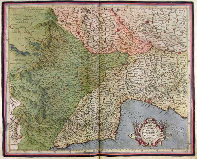
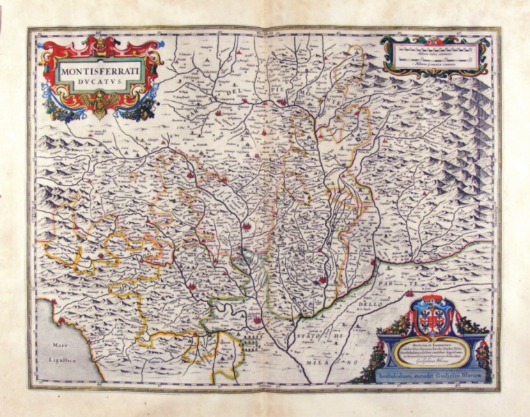
282-Montisferrati Ducatus - Piemonte - Italia .
The Charter, which measures 38 cm 49,5 x is located in the Atlas Theatrum Orbis Terrarum sive Atlas Novus-tertia pars of Guilelmus et Ioannis Blaeu, printed in Amsterdam in the workshop of Giovanni Blaeu in 1650. Offers the Monferrato region with the boundaries of areas of political influence of the time. Author: Ioannis Blaeu
Duisburg,1650 |
|
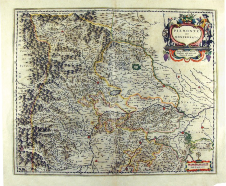
283-Piemonte et Monferrato - Italia .
The Charter, to what extent 52.4 x 42 cm, is contained in the Atlas Theatrum Orbis terrarum sive Atlas Novus is tertia pars of Guilelmus et Ioannis Blaeu, printed in Amsterdam in the workshop of Giovanni Blaeu in 1650. The document represents the States of mainland from Val d'Aosta and Piedmont to the borders to the South of Liguria and East State Milanese. Author: Ioannis Blaeu
Amsterdam,1650 |
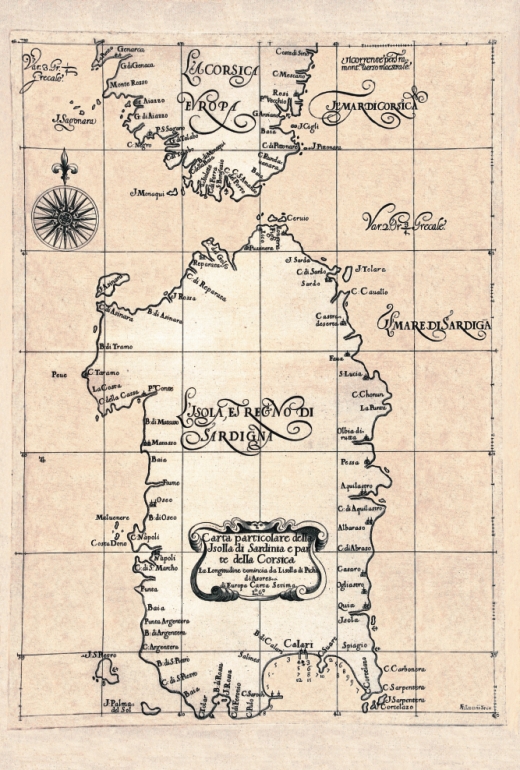
|
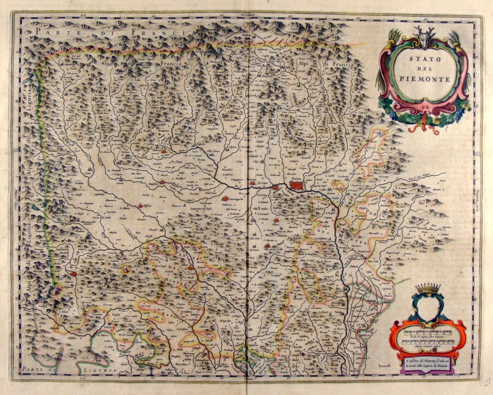
284-Stato del Piemonte - Italia .
The Charter, which measures ' 49.4 x 38.5 is located in the Atlas Theatrum Orbis terrarum sive Atlas Novus is tertia pars of Guilelmus et Ioannis Blaeu, printed in Amsterdam in the workshop of Giovanni Blaeu in 1650. Offers the western sector of Piedmont and is adorned by two l±d; the first top contains the title, the second bottom is surmounted by a Crown and contains two scales graphics. Author: Ioannis Blaeu
Amsterdam,1650 |
|
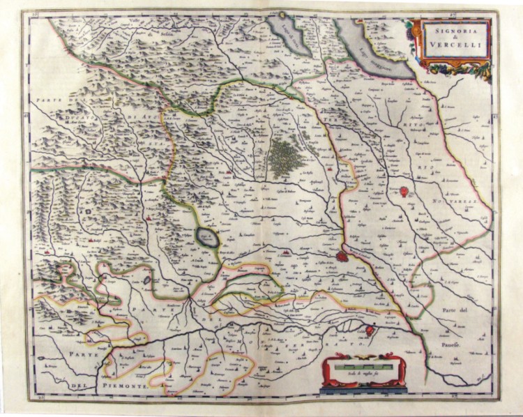
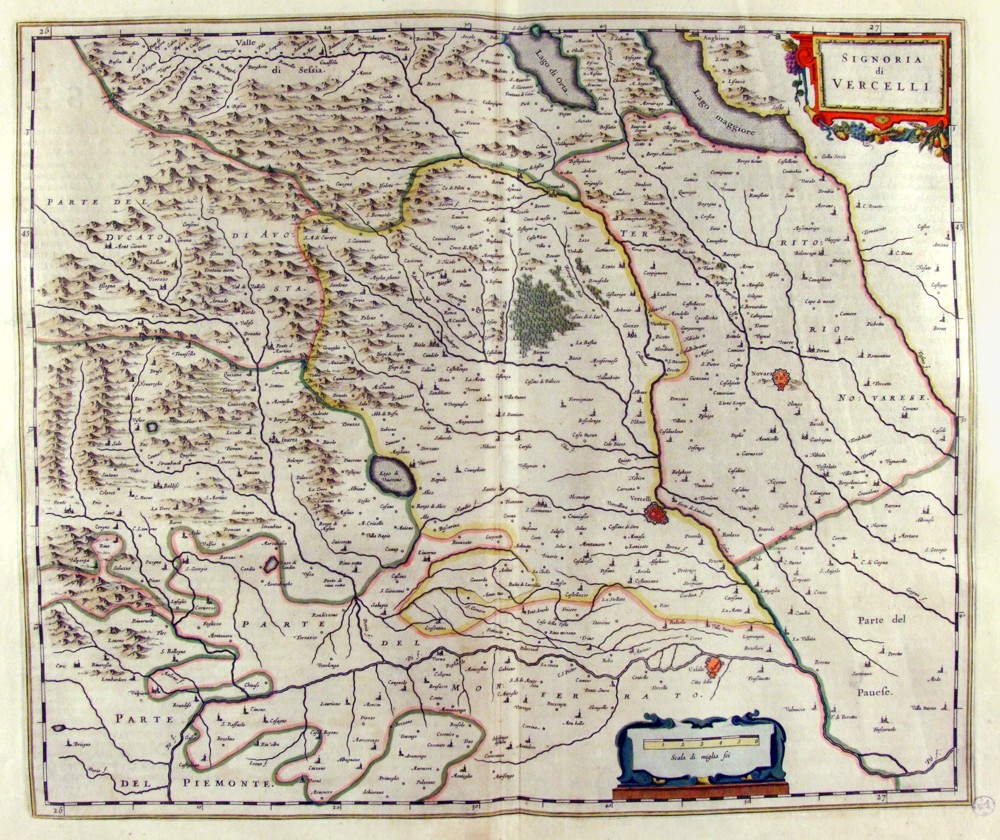
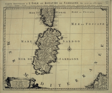
285-Signoria di Vercelli - Piemonte - Italia .
The Charter, which measures ' 50.5 x 41.5 is located in the Atlas Theatrum Orbis Terrarum sive Atlas Novus is tertia pars of Guilelmus et Ioannis Blaeu, printed in Amsterdam in the workshop of Giovanni Blaeu in 1650. Represents the area east of Piedmont with the towns of Vercelli and Novara. Author: Ioannis Blaeu
Amsterdam,1650 |
|
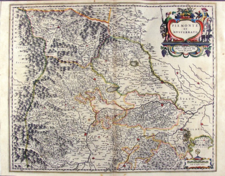
286-Piemonte et Monferrato - Italia .
The map is contained in the Atlas Geographiae Blavianae volumen octavum Quo Italy quae est Europae Liber XVI of Blaeu printed in Amsterdam in 1662. The document, which measures 52 x 42.5 cm, represents Piedmont Val d'Aosta and Monferrato. Author: Ioannis Blaeu
Amsterdam,1662 |
|
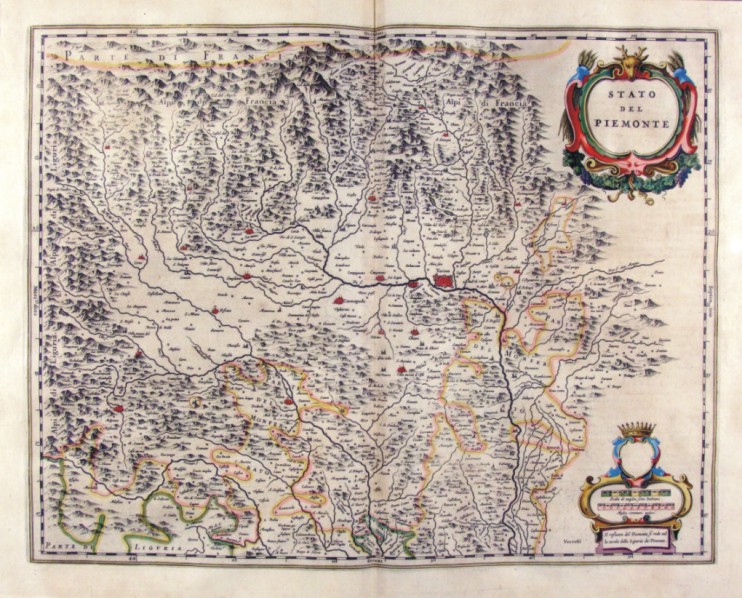
287-Stato del Piemonte - Italia .
The Charter, which measures in the drawing cm 49 x 38.5 is contained in the Atlas Geographiae Blavianae volumen octavum Quo Italy quae est Europae Liber XVI of Blaeu printed in Amsterdam in 1662. Represents the western sector of Reione and is adorned by two l±d; the top contains the title while the bottom contains two scales graphics in Italian and in miles miles. Author: Ioannis Blaeu
Amsterdam,1662 |
|
288-Signoria di Vercelli - Piemonte - Italia .
The Charter, which measures in the drawing cm 50 x 42 is contained in the Atlas Geogrphiae Blavianae volumen octavum Quo Italy quae est Europae Liber XVI of Blaeu printed in Amsterdam in 1662. The paper proposes the eastern area of Piedmont with the territories of Vercelli and Novara. Author: Ioannis Blaeu
Amsterdam,1662 |
|
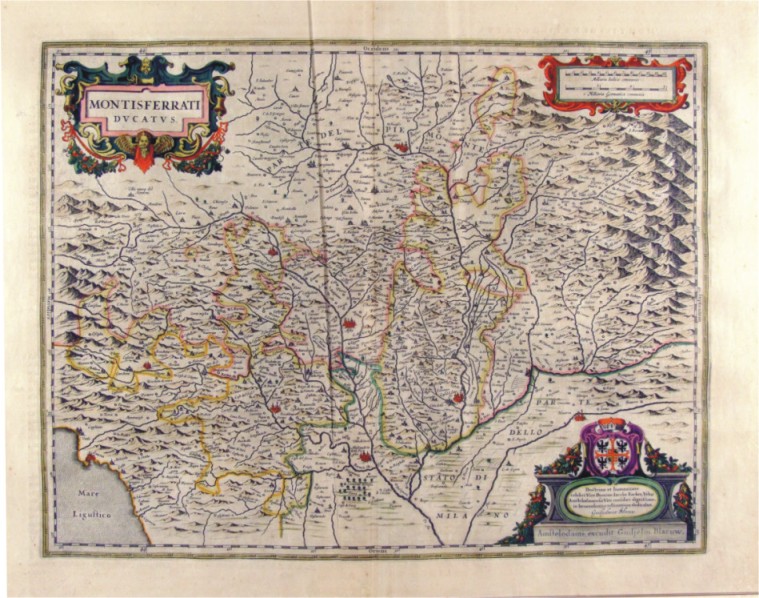
289-Montisferrati Ducatus - Piemonte - Italia .
The Charter, which measures in the drawing ' 48.1 x 37 is contained in the Atlas Geogrphiae Blavianae volumen octavum Quo Italy quae est Europae Liber XVI of Blaeu printed in Amsterdam in 1662. The Charter was realized by Guilelmus Blaeu, as indicated in the title block placed at the bottom right.
Author: Guilelmus Blaeu
Amsterdam,1662 |
|
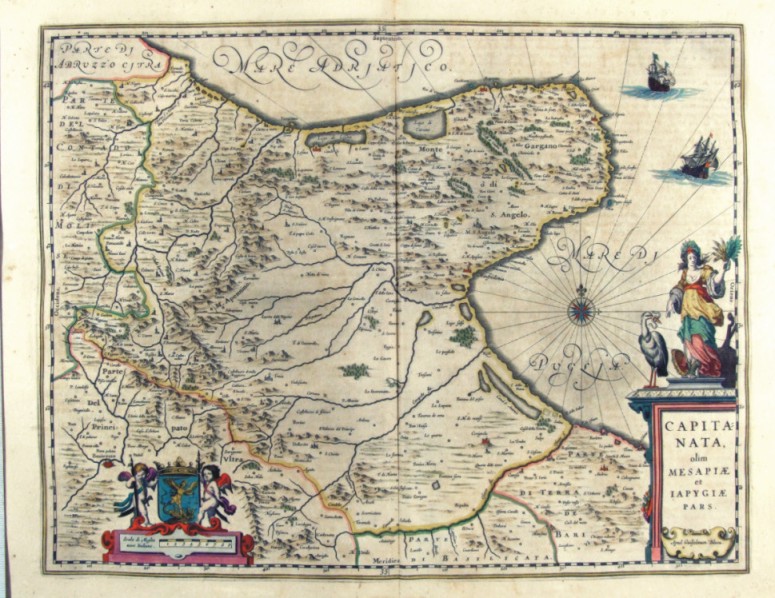
290-Capitanata olim mesapiae et iapygiae pars - Puglia - Italia .
The Charter, which measures in the drawing ' 49.2 x 38, is contained in the Atlas Geographiae Blavianae volumen octavum Quo Italy quae est Europae Liber XVI of Blaeu printed in Amsterdam in 1662.
Author: Ioannis Blaeu
Amsterdam,1662 |
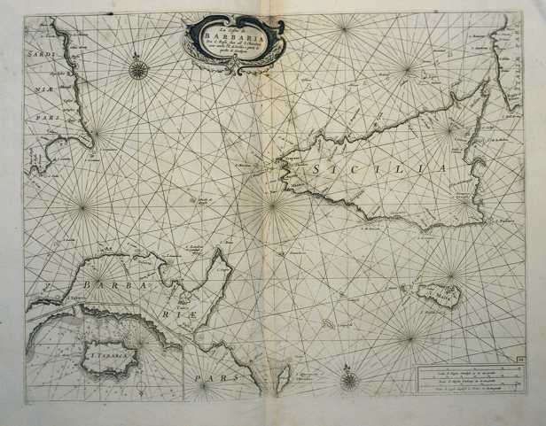
|
292-Capitanata olim mesapiae et iapygiae pars - Puglia - Italia .
The Charter, which measures in the drawing cm 49.2 x 38, is contained in the Atlas Geographiae Blavianae volumen octavum Quo Italy quae est Europae Liber XVI of Blaeu printed in Amsterdam in 1662.
Author: Jan Jansson
Amsterdam,1640 |
|
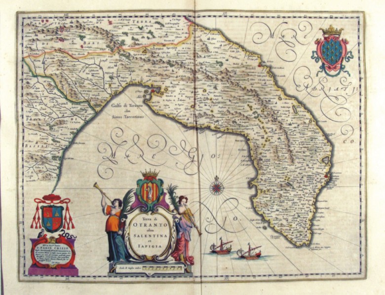
293-Terra di Otranto olim Salentina et Iapigia - Puglia - Italia .
The Charter, which measures in the drawing cm 50 x 38.5, is contained in the Atlas Geographiae Blavianae volumen octavum Quo Italy quae est Europae Liber XVI of Blaeu printed in Amsterdam in 1662.
Author: Ioannis Blaeu
Amsterdam,1662 |
|
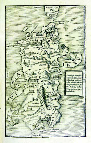
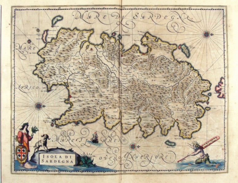
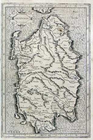
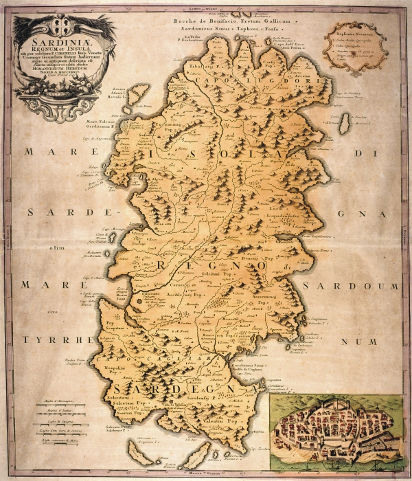
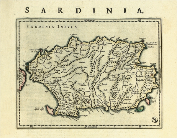
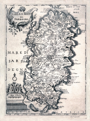
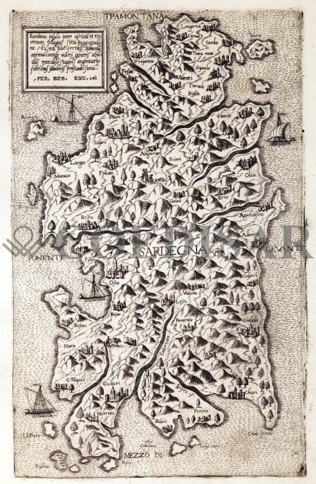
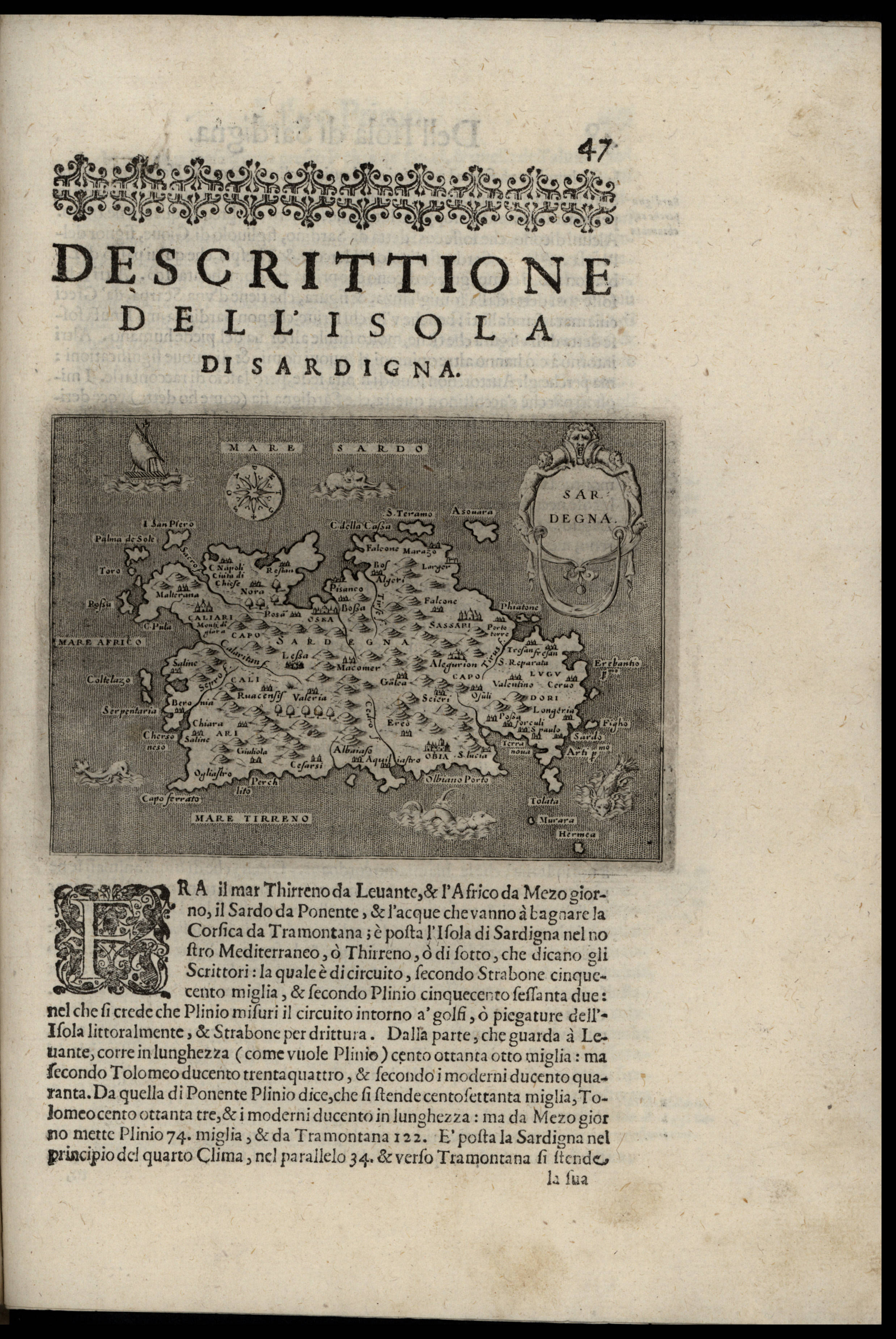
Sardinia Insula .
The map resides in Sebastiano Munster's atlas Cosmographiae universalis - Libri VI , edition released in 1554. It was taken from a woodcut and measures 25,5 x 15,5cm. In 1550 this atlas was published for the first time in latin. The document has no scale, parallels, meridians and it is not graduated in the margins. But we can see the cardinal points Occidens, Septentrio,Oriens, the South is missing. Author: Sigismondo Arquer
Basilea,1554 |
|
295-Island of Sardinia .
The map belongs to the atlas Italia di Gio Ant. Magini, published by the son of the author in 1620. It contains 61 maps. The 60th represents Sardinia and was realized before 1605. It's a colored map with graduated margins but no numerical references. The longitudes as well as the latitudes are subdivided in 1'. It measures 34,3 x 44,5 cm and it is on a scale of about 1:736 000. Author: Gio Antonio Magini
Bologna,1605 |
|
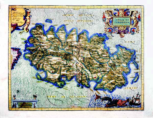
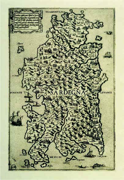
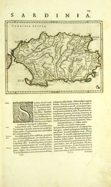
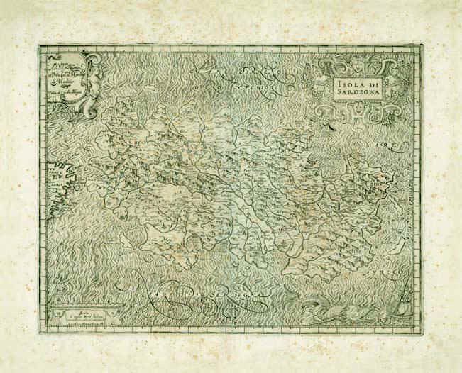
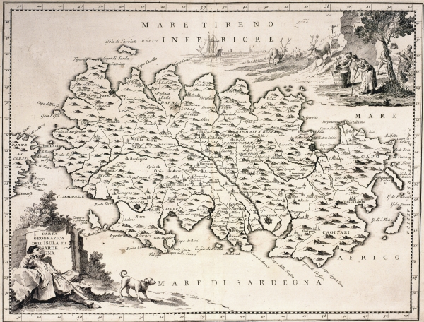
296-Isola di Sardegna .
The map of Sardinia, painted in water colours, has the West at the top, the North with a lily on the right and three wind roses over the sea. The more important towns like Cagliari, Oristagni, Bosa città , Algeri (Alghero), C. Aragonese (Castelsardo) and Terra Nuova (Olbia) are indicated with red perspective drawings, however the smaller places have just a little circle. The Gulf of Cagliari and the Gulf of Teulada are in the South, the Isola Rossa is indicated with a beautiful red colour. The islands of the Sulcis territory are correctly placed in the South West, Zamara o Asinara Isola, the Isola Piana and the Promontory of Monte Falco are in the North West, a non-existing group of islands (Isole Sanguinari), Serpentara and I Cavoli are in the South East.
A wonderful picture of an allegoric figure holding the blazon of the island (a shield with a red cross and four black Moors with a frontlet), includes the title. The figure is drawn with a large human foot refering to the Greek name of Sardinia Sandaliotis. On the bottom right a mythological figure over the sea holds a graduated scale of fifteen Italian miles on its shoulder.
Measuring 38 x 49,5 cm, this map comes from the atlas Geographiae Blavianae volumen octavum quo Italia quae est Europae liber sextus, continetur Amstelodami, Labore & Sumptibus Joannis Blaeu MDCLXII, printed in 1662 in Amsterdam.
Author: Ioannis Blaeu
Amsterdam,1662 |
|
297-Isola Regno di Sardegna .
The mapbelongs to the atlas Isolario descrittione Geografico è Historica, Author: P. Maestro Coronelli
Venezia,1690 |
|
299-Sardinia Insula .
The map is in a free format and measures 29,8 x 19 cm. It was probably printed in 1550 in Veneto from Fabio Licinio's cupper plate engraving. At tha time the map had a certain success because of its rich graphical contents. Therefore it was often copied and inserted with few variations in other cartographic works of the 16 th century.
Author: Fabio Licinio
Veneto,1550 |
|
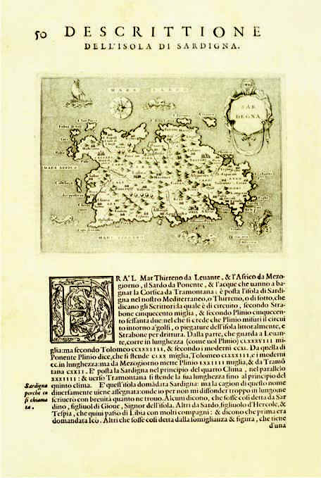
300-Descrittione dell'Isola di Sardegna .
The map measures 15,5 x19,2 cm, the drawing alone 10,3 x 14 cm. It resides in Porcacchi's and Arretino's atlas L'isole più famose del mondo, edition published in 1572 in Venice. The document was taken from Girolamo Porro's woodcut and proposes Gio. F. Camocio's map of 1571.
Author: Tommaso Porcacchi
Venezia,1571 |
|
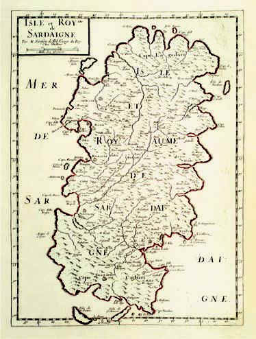
301-Isle et Royme de Sardaigne .
The map measures 39 x 28,7 cm and belongs to the atlas N. Sanson d'Abbeville Cartes generales de toutes le parties du monde, ou les empires, monarchies, republiques, etats, peuples et de l'Asie, de l'Afrique, de l'Amerique sont exactement remarques et distinguèes suivant leur estenduè, Paris, l'autheur, P. Mariette, 1658 . Considering the longitude of the major Island, the scale is about 1:760 000. The margins are graduated and subdivided in 2'30''. The numeral values are marked from 10' to 10'. Author: Nicola Sanson
Parigi,1658 |
|
302-Sardinia .
The map measures 19,2 x 14,6 cm and belongs to the latin edition of G. and I. Blaeu's atlas Theatrum Orbis Tertrarum sive Atlas Novus, part III, printed in 1640 in Amsterdam. Considering the long side of the island, Sardinia is on a scale of 1:1 525 000 and exposed in horizontally position, with the North on the left. The coast profil is well delineated, the most important promontories are marked and the gulf of Cagliari is correctly oriented.
Author: Gulielmus e Ioannis Blaeu
Amsterdam,1640 |
|
303-Island of Sardinia .
The map measures 34 x 44,5 cm and belongs to Magini's Atlas Italia, printed in 1620 in Bologna. Considering the long side of the island, the scale is about 1:736 000. The margins are graduated and subdivided in 1', but there are no numeral references.The edge beneath on the right is decorated with a seamonster tracking a sailing vessel. The other edges have three decorated pictures, the one above on the right contains the title Isola di Sardegna
Author: Giovanni Antonio Magini
Bologna,1620 |
|
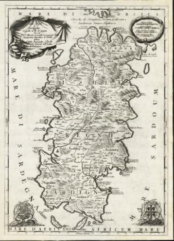
304-Nova et acurata Totius Sardiniae Tabula .
The rather big map, printed in 1720, measures 113,5 x 74 cm, has no gradueted margins but four decorated pictures. It's the first cartographic document realized by the House of Savoy after acquiring the Empire of Sardinia. Author: Domenico Colombino
,1720 |
|
306-Contour of the Sardinia's Empire Map .
The map was probably drawn in 1788 from Maina's original design of 1746. Painted with watercolours, it measures 48 x 31,1 cm and has three decorated pictures and seven wind roses.
Author: Craveri
Cagliari,1788 |
|
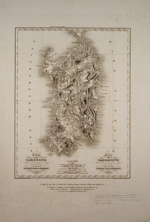
310-Carta della Sardegna .
The map measures 35 x 27 cm and holds an italian and french inscription indicating the same engraving plate of the 1838 edition. Author: Alberto Lamarmora
,1838 |
|
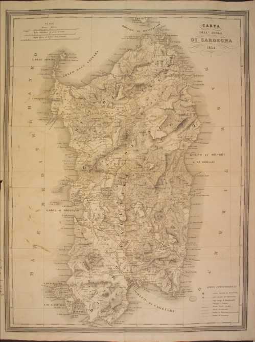
311-Carta dell' Isola di Sardegna .
The map measures 35 x 27 cm and holds an italian and french inscription indicating the same engraving plate of the 1838 edition. Author: Casalis
,1854 |
|
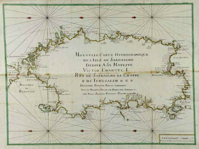
314-Sardaigne Hydrographique .
The colored map was printed in 1813 and measures 72 x 124 cm. There are neighter graduated margins nor geographic coordinates. Except from the title, the map inside is empty. But the coast contour is rich of names. It's the second edition of a map printed in 1785-88.
Author: Francois Giaume
,1813 |
|
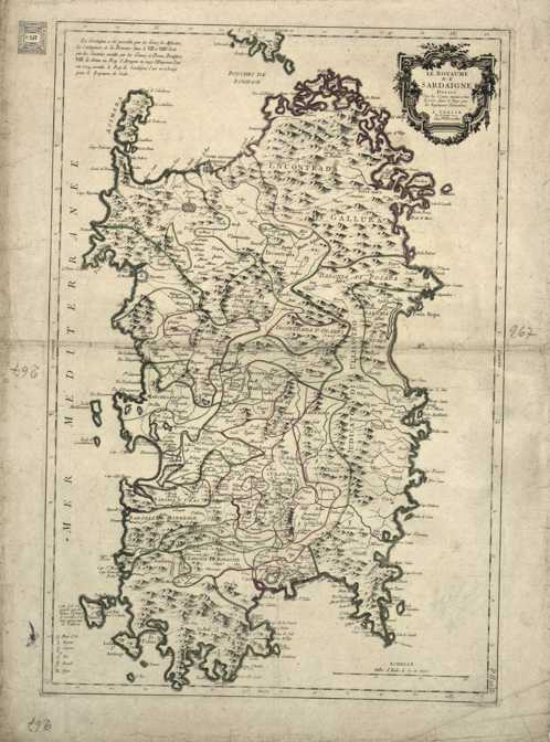
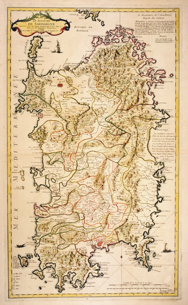
315-Le Royaume de Sardaigne .
The map was printed 1779 in Venice at Ramondini's workshop. It measures 42 x 66 cm, it is written in Italian and French and was taken from a cupper plate engraving,. It's a beautiful map with an orographic perspective representation. Author: P. Santini
Venezia,1779 |
|
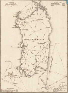
316-Carte demonstrative de la triangulation de 1er ordre executee en sardaigne de 1835 a .
The map is on a scale of 1:1 000 000, measures 35,2 x 26 cm and proposes the basis of the first topographic measurement of the Sardinia Island.
Author: Alberto Lamarmora
,0 |
|
321-Sardegna .
The design measures 22,5 x 38 cm, the map 27,5x 44cm. It resides on page 280, 4th edition of the Atlas sive Cosmographicae meditationes de fabrica mundi et fabricati figura" ,printed in 1611 in Amsterdam. Author: Gerardo Mercatore
Amsterdam,1611 |
|
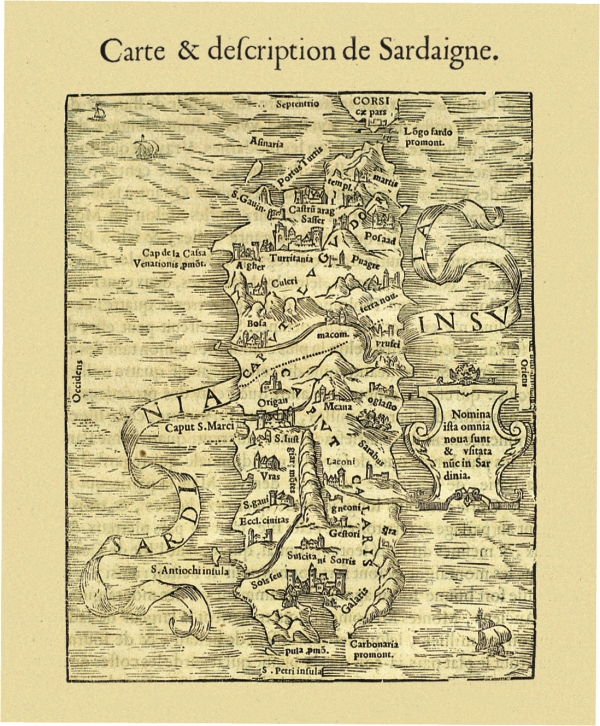
323-Carte & descripption de Sardaigne .
The paper measure cm 15,5 x 7.6, and is located at p. 213 Atlas Discours Historial de antique et illustre citè de Nismes En la Gaule Narbonoise, Avec les portraits des plus antiques et insignes bastimens du lieu dit, reduits to leur vraye mesure et proportion, ensemble de antique et moderne Ville is Par Jean Poldo Of Albenas, in Lyon, par Guillome Roville. Avec privilege pour dix ans 1560. On the last page however appears as date printed on 15th April 1564. This document map feature of Sardinia shows no significant new elements with respect to knowledge of the time and again, with a few insignificant variations, the paper made by Sigismondo Arquer and published by Munster in Latin language edition of his Atlas of 1550. Author: Antoine Du Pinet De Norot
,1560 |
|
Sardinia .
The map was taken from the atlas Theatri Geographiae Veteris Tomus Prior in quo Cl. Ptol. Alexandrini Geographiae libri VIII, printed in 1619 in Amsterdam.
The map measures 32,3 x 45,8cm and represents Sardinia, South Corsica and a small sector of the South West of Italy which corresponds to South Calabria looking onto the Thyrrenian Sea , Sicily and the Aegadian and Aeolian Islands. Author: Pietro Bertio
Amsterdam,1619 |
|
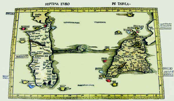
325-Septima Europe Tabula .
The map resides on table 9 of the atlas Ptolomeus Auctus restitutus et maculatus cum tabulis veteribus ac novis. Typus Joannis Scoti, printed in 1520 in Strassbourg. It also contains the map before.The colored document measures 54,5 x 32 cm, has an accurate and fine graphic art and represents a sector of the Earth with restriction in the North. The map is graduated with 1° intervals and shows the latitude from 35°,30' to 40°,30' and the longitude from 30° to 40°,30'.
Author: Claudio Tolomeo
Strasburgo,1520 |
|
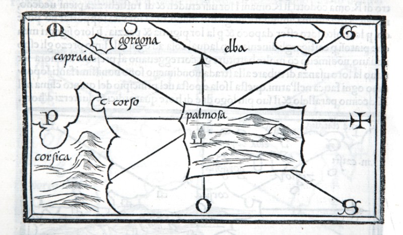
326-Le Coste della Barbaria da Capo Rosafino all'isola Chercheni con anche l'isola di Sic .
The map measures 40 x 50,6 cm and belongs to the atlas Prima parte dello Specchio del Mare, published in 1664 in Genoa by F.M.Levanto. It exposes the South of the Thyrrenian Sea with the channel of Sardinia and Sicily, a sector of Tunisia with Cap Bon, the islands of Sicily, Malta Lampedusa and East Sardinia with the gulf of Cagliari. Tabarca, at that time frequented by the Genoese navigators, is represented with its surrounding sea bed in a very detailed way on the sector below on the left. Author: Francesco Maria Levanto
Genova ,0 |
|
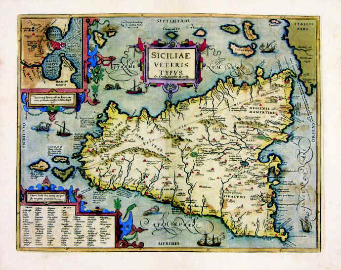
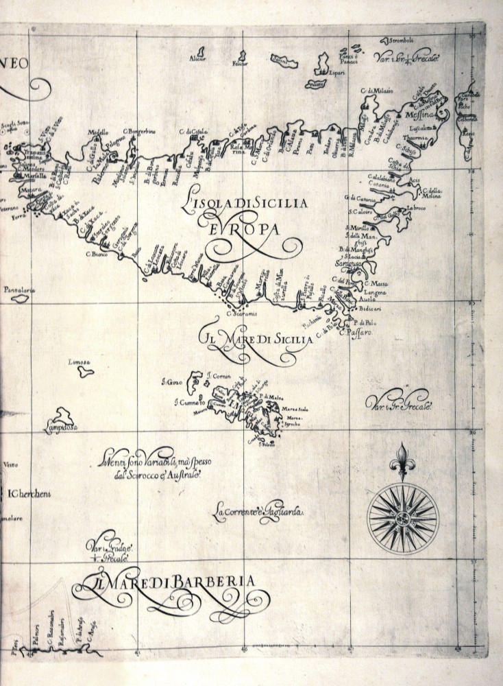
327-Siciliae Veteris .
The drawing of the map measures 36 x 47 cm and belongs to the atlas Theatrum Orbis Terrarum, edition of 1589. It's a very beaultiful and well colored map. Syracuse and its harbour are represented in a square above.
Author: Abramo Ortelio
Anversa,1584 |
|
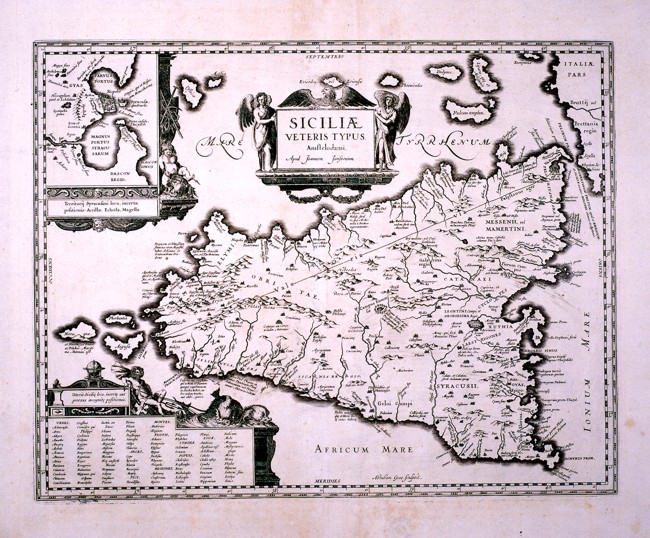
328-Siciliae e Veteris Tipus .
This map, drawn by Johannes Janssonius, comes from the same matrix as the map in the Ortelius atlas Theatrum Orbis Terrarum and shows only few differences. It measures 44 x 36 cm.
Author: Johannem Janssonium
,1589 |
|
332-Toscana - Italia .
The map belongs to the Atlas sive Cosmographicae Meditationes de Fabrica Mundi et Fabricati Figura, published in 1644 in Duisburg.
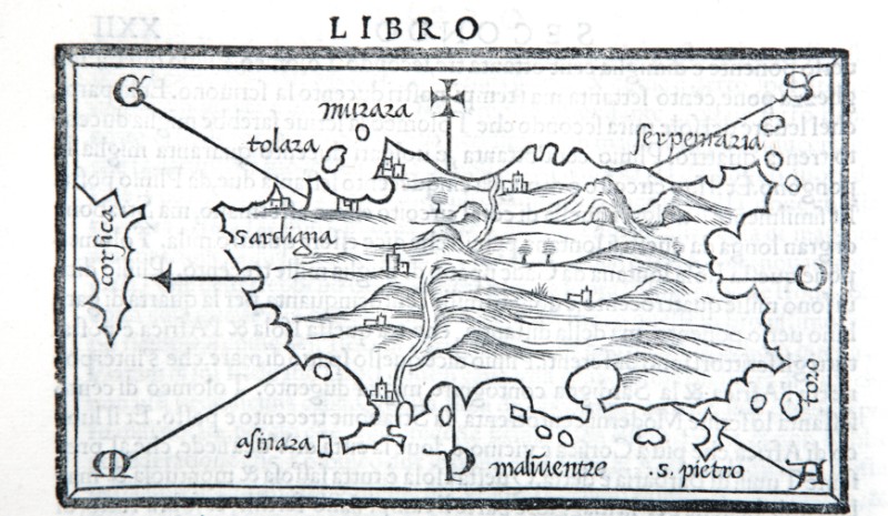
Dimensions: 46 x 32 cm Author: Gerardo Mercatore
Duisburg,1644 |
|
335-Dominio Fiorentino - Toscana - Italia .
The Charter, which measures in the drawing cm 50 x 38.5, is contained in the Atlas Geographiae Blavianae volumen octavum Quo Italy quae est Europae Liber XVI of Blaeu printed in Amsterdam in 1662.
Author: Ioannis Blaeu
Amsterdam,1662 |
|
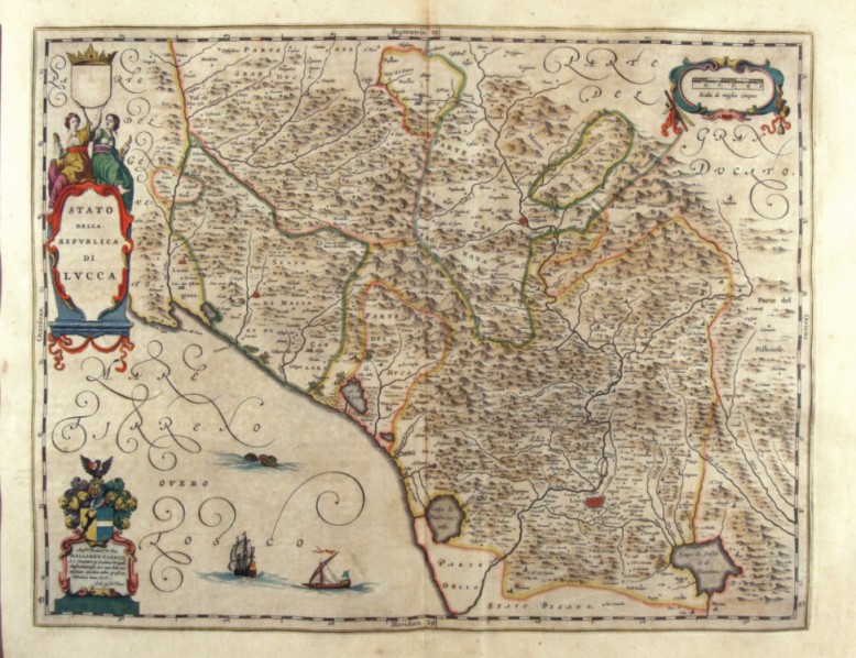
337-Stato della Repubblica di Lucca - Toscana - Italia .
The Charter, which measures in the drawing cm 49,5 x 38.5, is contained in the Atlas Geographiae Blavianae volumen octavum Quo Italy quae est Europae Liber XVI of Blaeu printed in Amsterdam in 1662.
Author: Ioannis Blaeu
Amsterdam,1662 |
|
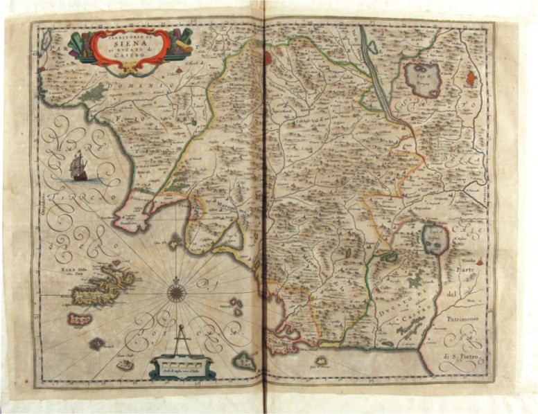
338-Territorio di Siena et Ducato di Castro - Toscana - Italia .
The Charter, which measures in the drawing cm 48 x 38, is contained in the Atlas Geographiae Blavianae volumen octavum Quo Italy quae est Europae Liber XVI of Blaeu printed in Amsterdam in 1662.
Author: Ioannis Blaeu
Amsterdam,1662 |
|
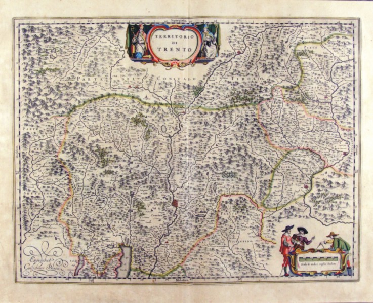
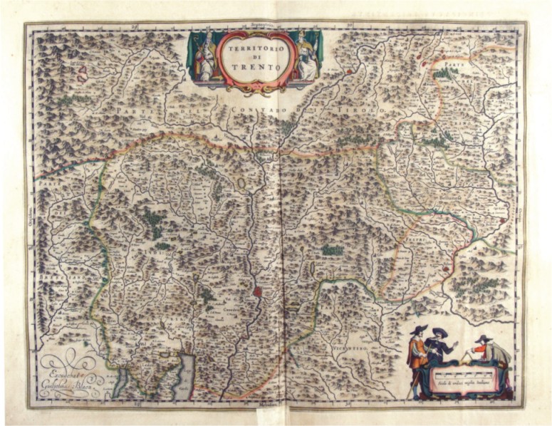
339-Territorio di Trento - Trentino Alto Adige - Italia .
The Charter, which measures cm 49,7 x 38 is located in the Atlas Theatrum Orbis Terrarum sive Atlas Novus-tertia pars of Guilelmus et Ioannis Blaeu, printed in Amsterdam in the workshop of Giovanni Blaeu in 1650. The card offers the mountain region of Trentino with a scroll at the top that contains the title and down the metric scale orbnata 3 figures of Surveyors.
Author: Ioannis Blaeu
Amsterdam,1650 |
|
340-Territorio di Trento - Trentino Alto Adige - Italia .
The Charter, which measures in cm 50 x 38.5 drawing is contained in the Atlas Geographiae Blavianae volumen octavum Quo Italy quae est Europae Liber XVI of Blaeu printed in Amsterdam in 1662. Author: Ioannis Blaeu
Amsterdam,1662 |

|
348-Verona Vicenza - Italia .
The map belongs to the Atlas sive Cosmographicae Meditationes de Fabrica Mundi et Fabricati Figura, published in 1644 in Duisburg. Author: Gerardo Mercatore
Duisburg,1644 |
|
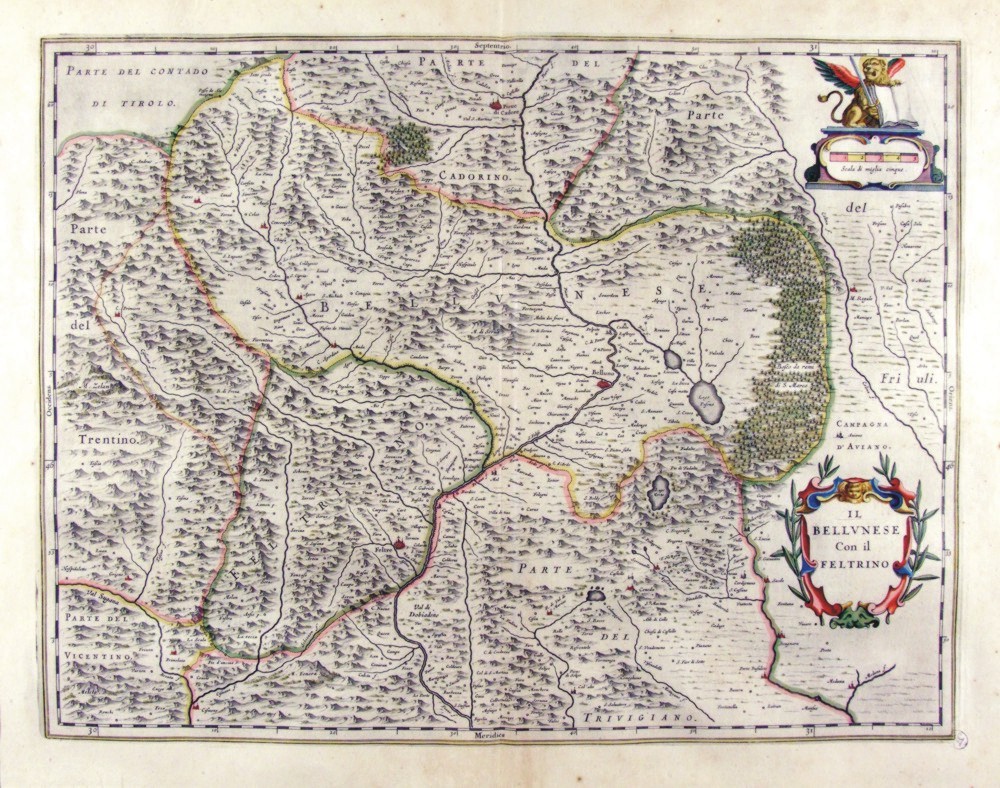
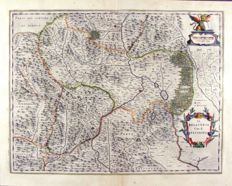
350-Il Bellunese con il Feltrino - Veneto - Italia .
The Charter, which measures 49,7 x 38 cm is located in the Atlas Theatrum Orbis Terrarum sive Atlas Novus-tertia pars of Guilelmus et Ioannis Blaeu, printed in Amsterdam in the workshop of Giovanni Blaeu in 1650. The Charter represents the area north of the domains of Earth Republica of Venice with the woods of the Bellunese reserved to cut to the oars of galleys.
Author: Ioannis Blaeu
Amsterdam,1650 |
|
351-Verona Vicenza - Italia .
The map belongs to the Atlas sive Cosmographicae Meditationes de Fabrica Mundi et Fabricati Figura, published in 1644 in Duisburg.
Author: Gerardo Mercatore
Duisburg,1644 |
|
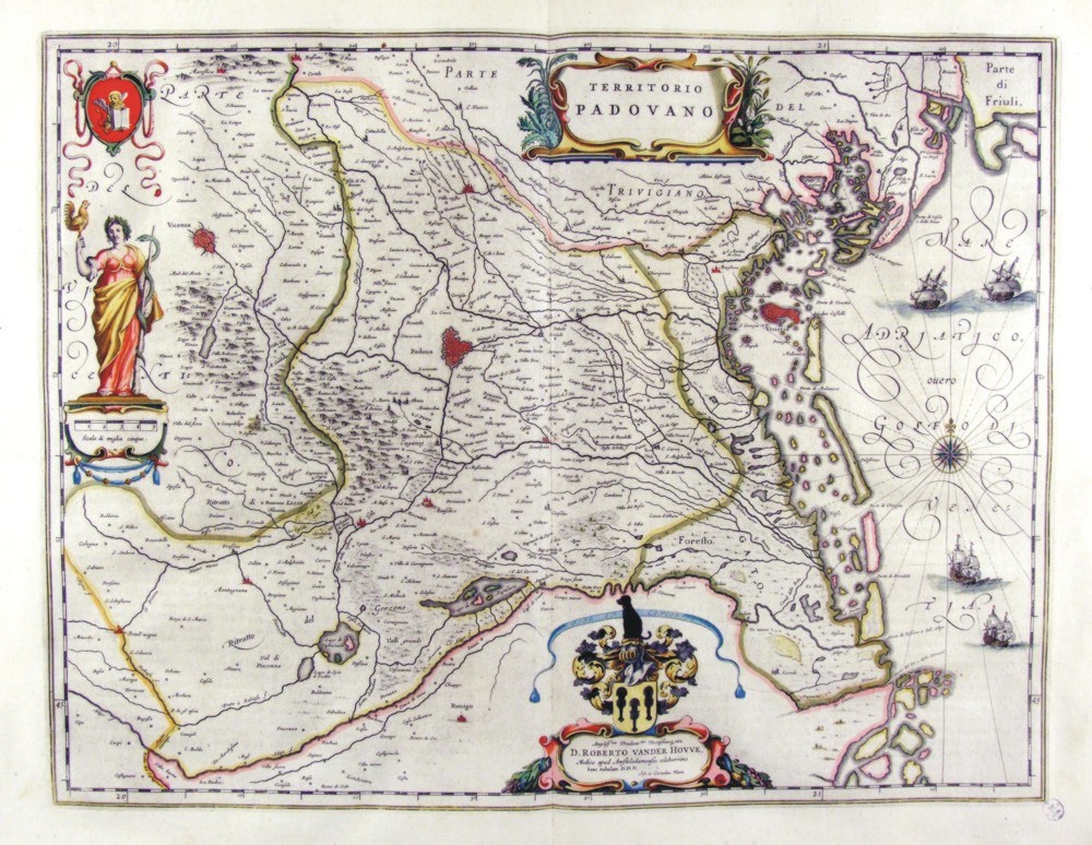
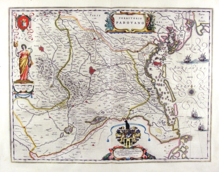
352-Territorio Padovano - Veneto - Italia .
The Charter, to what extent 49,7 x 38 cm is located in the Atlas Theatrum Orbis Terrarum sive Atlas Novus-tertia pars of Guilelmus et Ioannis Blaeu, printed in Amsterdam in the workshop of Giovanni Blaeu in 1650, but has been realized by Ihoannes and Cornelius Blaeu. Represents the eastern part of the Pianura Padana, sector of Verona and until March, and is enriched by various designs such as the lion of Venice, an allegorical figure with the serpent of Aesculapius a cartouche with dedication to the doctor d. Roberto Vander Hovve.
Author: Ioannis Blaeu
Amsterdam,1650 |
|
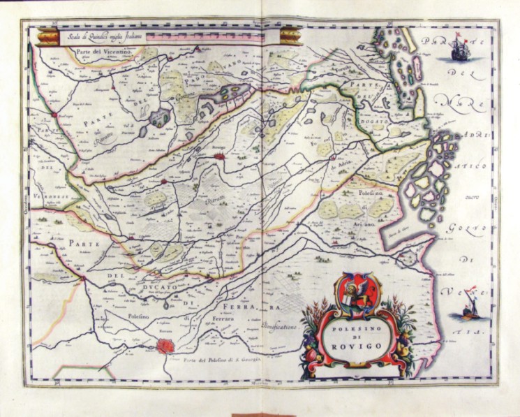
353-Polesino di Rovigo - Veneto Italia .
The map, which measures 49,7 x 38 cm is located in the Atlas Theatrum Orbis Terrarum sive Atlas Novus-tertia pars of Guilelmus et Ioannis Blaeu, printed in Amsterdam in the workshop of Giovanni Blaeu in 1650. The Charter represents the Polesine, which is the sector most depressed the Po with Rovigo to downtown and the Duchy of Ferrara at the bottom. On top is the proposal a metric scale and lower right a cartouche with the title. Author: Ioannis Blaeu
Amsterdam,1650 |
|
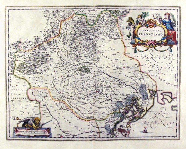
354-Territorio Trevigiano - Veneto - Italia .
The map, to what extent 49,7 x 38 cm is located in the Atlas Theatrum Orbis Terrarum sive Atlas Novus-tertia pars of Guilelmus et Ioannis Blaeu, printed in Amsterdam in the workshop of Giovanni Blaeu in 1650
Author: Ioannis Blaeu
Amsterdam,1650 |
|
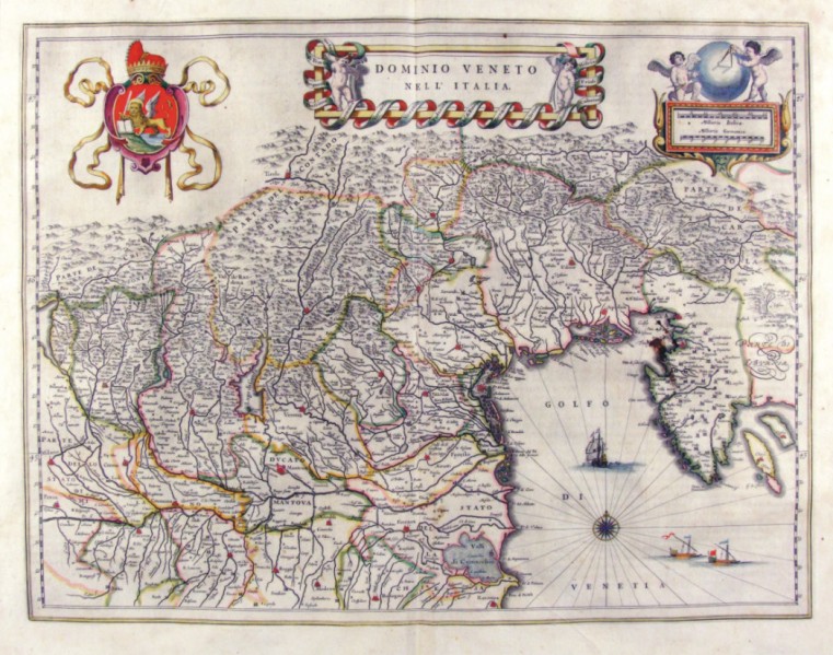
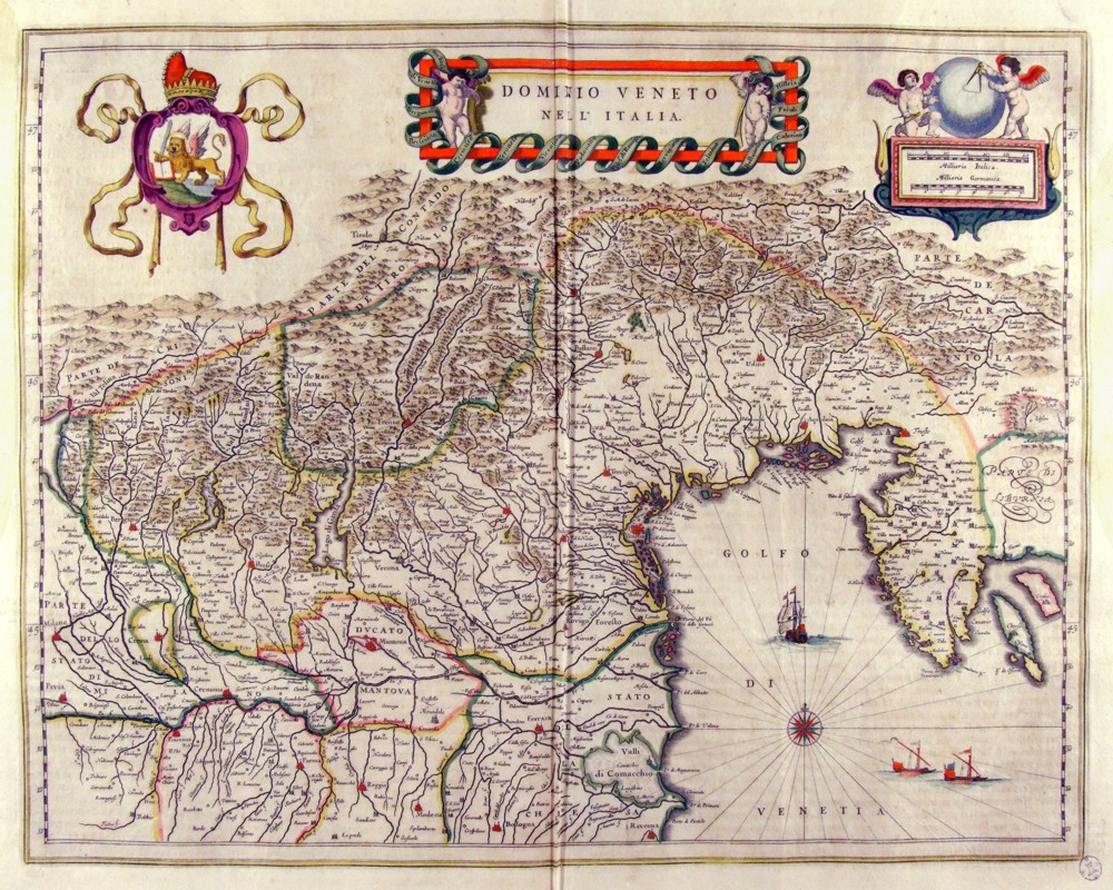
355-Dominio Veneto nell'Italia - Veneto - Italia .
The map measures 50 x 38 cm and belongs to the atlas Theatrum Orbis Terrarum sive Atlas Novus - pars tertia - Guilelmus et Ioannis Blaeu, printed in 1650 in the Blaeu's family workshop in Amsterdam. It's a historically interesting document exposing the dominions of the Republic of Venice in the North of Italy. A wonderful decorating picture shows the Lion of San Marco.
Author: Ioannis Blaeu
Amsterdam,1650 |
|
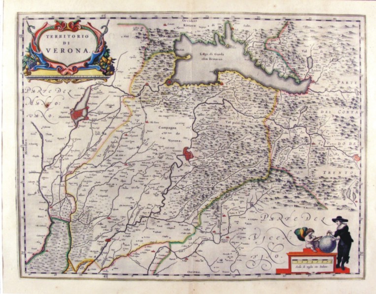
360-Territorio di Verona - Veneto - Italia .
The Charter, to what extent 49.7 x 38,5 cm is located in the Atlas Theatrum Orbis Terrarum sive Atlas Novus-tertia pars of Guilelmus et Ioannis Blaeu, printed in Amsterdam in the workshop of Giovanni Blaeu in 1650. The Charter, which proposes the lable with the title at the top and bottom right a cartographer with globe, represents the area of Verona, Mantua from Duchy to the countryside of Trento.
Author: Ioannis Blaeu
Amsterdam,1650 |
|
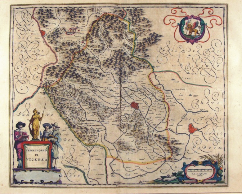
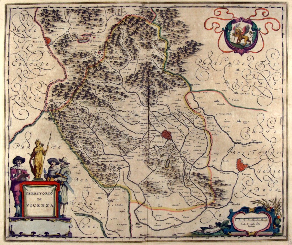
361-Territorio di Vicenza - Veneto - Italia .
The map, to what extent 49.7 x 41.5 cm is located in the Atlas Theatrum Orbis Terrarum sive Atlas Novus-tertia pars of Guilelmus et Ioannis Blaeu, printed in Amsterdam in the workshop of Giovanni Blaeu in 1650
Author: Ioannis Blaeu
Amsterdam,1650 |
|
362-Dominio Veneto nell'Italia - Veneto - Italia .
The map, which measures in the drawing cm 49 x 38.5 is contained in the Atlas Geographiae Blavianae volumen octavum Quo Italy quae est Europae Liber XVI of Blaeu printed in Amsterdam in 1662.
Author: Ioannis Blaeu
Amsterdam,1662 |
|
363-Territorio di Verona - Veneto - Italia .
The map, which measures in the drawing 50.2 x 38,5 cm is contained in the Atlas Geographiae Blavianae volumen octavum Quo Italy quae est Europae Liber XVI of Blaeu printed in Amsterdam in 1662.
Author: Ioannis Blaeu
Amsterdam,1662 |
|
364-Territorio di Vicenza - Veneto - Italia .
The map, which measures in the drawing 49.6 x 41.5 cm is contained in the Atlas Geographiae Blavianae volumen octavum Quo Italy quae est Europae Liber XVI of Blaeu printed in Amsterdam in 1662.
Author: Ioannis Blaeu
Amsterdam,1662 |
|
365-Territorio Padovano Veneto - Italia .
The map, which measures in the drawing 50.5 x 39 cm is contained in the Atlas Geographiae Blavianae volumen octavum Quo Italy quae est Europae Liber XVI of Blaeu printed in Amsterdam in 1662.
Author: Ioannis Blaeu
Amsterdam,1662 |
|
366-Polesino di Rovigo - Veneto - Italia .
The map, which measures in the drawing cm 49,5 x 38.5 is contained in the Atlas Geographiae Blavianae volumen octavum Quo Italy quae est Europae Liber XVI of Blaeu printed in Amsterdam in 1662.
Author: Ioannis Blaeu
Amsterdam,1662 |
|
367-Territorio Trevigiano Veneto - Italia .
The map, which measures in the drawing 49.7 x 38,5 cm is contained in the Atlas Geographiae Blavianae volumen octavum Quo Italy quae est Europae Liber XVI of Blaeu printed in Amsterdam in 1662.
Author: Ioannis Blaeu
Amsterdam,1662 |
|
368-l Bellunese con il Feltrino - Veneto - Italia .
The map, which measures in cm 50 x 38.5 drawing is contained in the Atlas Geographiae Blavianae volumen octavum Quo Italy quae est Europae Liber XVI of Blaeu printed in Amsterdam in 1662.
Author: Ioannis Blaeu
Amsterdam,1662 |
|
369-Il Cadorino Veneto - Italia .
The map, which measures in cm 50 x 38.5 drawing is contained in the Atlas Geographiae Blavianae volumen octavum Quo Italy quae est Europae Liber XVI of Blaeu printed in Amsterdam in 1662.
Author: Ioannis Blaeu
Amsterdam,1662 |
|
402-Sardegna Van Keulen .
This map comes from the Ioannes van Keulen atlas Zee-Atlas ofte Water Waereld, printed in 1706 in Amsterdam. Author: Van Keulen
Amsterdam,1706 |
|
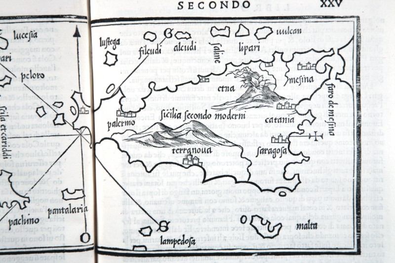
419-Sicilia .
Author: Robert Dudley
Firenze,1661 |
|
429-Arcipelago Toscano .
Author: Benedetto Bordone
,1528 |
|
434-ISOLE SICILIA .
The map measures 14.6 x 8.4 cm in the design and the work is published in Venice in 1528 Libro di Benedetto Bordone nel qual si ragiona di tutte l’isole del mondo con li loro nomi antichi et moderni, historie, favole, et modi di loro vivere, et in qual parte del mare stanno, et in qual parallelo et clima giacciono con il breve di Papa Leone et gratia et pri vilegio della Illustrissima Signoria com’in quelli appare. MDXXVIII. Author: Benedetto Bordone
Venezia,1528 |
|
435-Isole toscana .
Author: Bordone
,0 |
|
445-Sardegna Bordone Particolate .
Author: Bordone
Venezia,1534 |
|
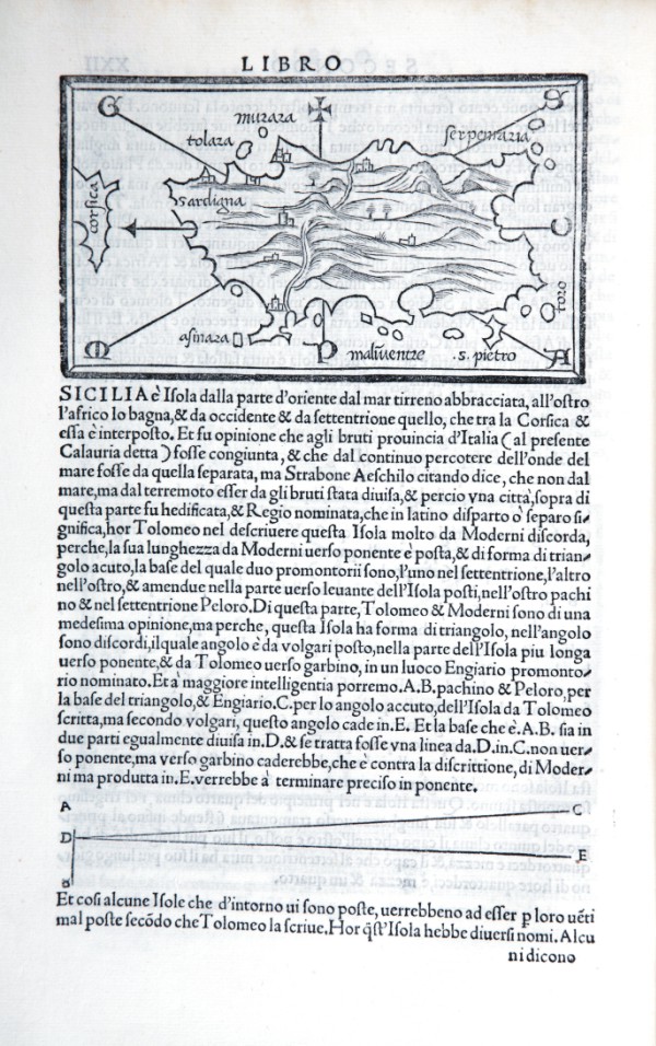
446-Sardegna di Bordone e descrizione di Sicilia .
The map measures 8.4 x 14.6 cm in the design and the work is published in Venice in 1528 Libro di Benedetto Bordone nel qual si ragiona di tutte l’isole del mondo con li loro nomi antichi et moderni, historie, favole, et modi di loro vivere, et in qual parte del mare stanno, et in qual parallelo et clima giacciono con il breve di Papa Leone et gratia et pri vilegio della Illustrissima Signoria com’in quelli appare. MDXXVIII.
the left, while overhead a cross indicates the East, presents the directions of the eight principal winds but does not accompany the graded edges, or to map grid, or of scale. The name of the island lies in the north-east and on the left is represented the extreme southern part of Corsica in the name of that island.
Author: Bordone
Venezia,1528 |
|
447-Sicilia 2 .
The map measures 8.4 x 14.6 cm in the design and the work is published in Venice in 1547 Libro di Benedetto Bordone nel qual si ragiona di tutte l’isole del mondo con li loro nomi antichi et moderni, historie, favole, et modi di loro vivere, et in qual parte del mare stanno, et in qual parallelo et clima giacciono con il breve di Papa Leone et gratia et pri vilegio della Illustrissima Signoria com’in quelli appare. Author: Benedetto Bordone
Venezia,1528 |
|
448-Sicilia particolare .
The map measures 14.6 x 8.4 cm in the design and the work is published in Venice in 1528 Libro di Benedetto Bordone nel qual si ragiona di tutte l’isole del mondo con li loro nomi antichi et moderni, historie, favole, et modi di loro vivere, et in qual parte del mare stanno, et in qual parallelo et clima giacciono con il breve di Papa Leone et gratia et pri vilegio della Illustrissima Signoria com’in quelli appare. MDXXVIII.
Author: Benedetto Bordone
Venezia,0 |
|
449-Sicilia di Bordone .
The map measures 14.6 x 8.4 cm in the design and the work is published in Venice in 1528 Libro di Benedetto Bordone nel qual si ragiona di tutte l’isole del mondo con li loro nomi antichi et moderni, historie, favole, et modi di loro vivere, et in qual parte del mare stanno, et in qual parallelo et clima giacciono con il breve di Papa Leone et gratia et pri vilegio della Illustrissima Signoria com’in quelli appare. MDXXVIII. Author: Benedetto Bordone
Venezia,1528 |
|
466-SARDEGNA .
The name is placed at the center of Sardinia, Cagliari Chief among the signs to the South and the North Cape LOGUDORO. Major cities are marked by their fortifications, with well-placed Cagliari in the south, west and Oristano Sassari in north-west. It is located on the map in scale 1: 2,600,000 designed in 1700 by French geographer Guillaume De L'Isle entitled : L’Italie. Dressee sur les observations de Mrs. de l’Academie Royale des Sciences sur celles du R.P. Riccioli de la Compagnie de Jesus, et autres astronomes du pays, et sur plusieurs autres memoires. Par G. De l’Isle, Geographe. A Paris, chez l’Auteur sur le Quai de l’Horloge, avec Privilege du Roy, pour 20 ans, M.D.CC. Grave par Berey.Top left is a scroll with a range of scales used in the territories represented: Milliaria Principatus Pedemonty, MilliriaAnconitana, Milliria Boniae et Ravennae, Milliria communia Italica, Milliria Florentina, Milliria Genuesia, Milliria Parmensia, Milliria Venetia, Milliria Mutinensia, Milliria Roma, Milliria Mantua, Milliria Ferrarensie, Milliria Gallica commu(nia).
Author: Seutter
Augusta,1730 |
|
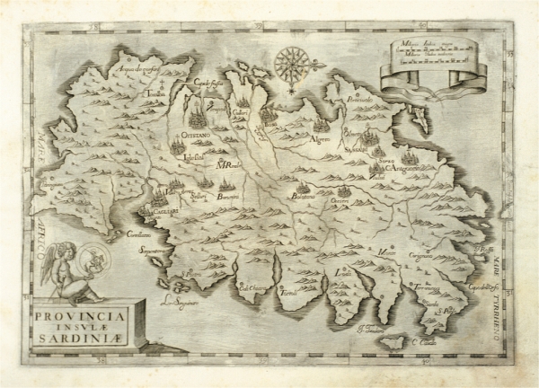
643-Provincia Insulae Sardinae .
Author: Bernard Bourdigalensis
Roma,1643 |
|
507-sardegna .
Map of the island or the kingdom of Sardinia with care reduced by the most accredited materials and proper behind recent news. Map black and white made in 1857 and printed by litho junker Turin Turin. Author: G. Biasioli
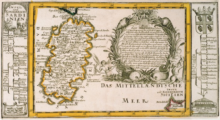
Torino,1857 |
|
609-Sardinien .
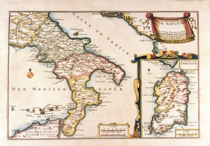
Author: Gabriel Bodenehr
Augusta,1704 |
|
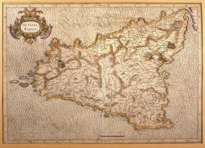
608-Siciliae Regnum .
This map, measuring 34 x 48 cm and drawn by Gerardus Mercator, was printed in 1589 in Duisburg. It is a beautiful document of Sicily, its inhabited centres drawn with little circles and the towns with fine perspective designs. The island appears in the centre of the sea, moved by light waves. The mountains are indicated by mole-hill reliefs and the water courses are exactly described. On the top left is a decorative title picture; the graphic scale in Miliaria Italica Communia is at the bottom. Author: Mercatore
Duisburg ,1589 |
|
612-Le Royame de Naples .
This map, measuring 22 x 32,7 cm and drawn by N. de Fer, Geographe de Monseigneur de Dauphin, is taken from the Atlas curieux ou le Monde représenté dans les cartes générales et particulières du ciel et de la terre (...),printed in 1705 in Paris.
It is a beautiful coloured document. A festoon on the top right contains the title. The graphic scales Echelle Soixante Milles d'Italie and Vingt Lieues d’un heure de chemin are in a square at the bottom. The Sardinia Island with its own graphic scale appears separately on the right. Author: Dauphin
Paris,1705 |
|
619-Isle et Royame de Sardaigne .
Color map, derived from an engraving in copper alloys by Jean baptiste Nolin (1657-1708). L Charter is taken from opera Le Theatre du Mond dedié au Roi pleased the cartes générales et particulieres roiames et des Etats qui le composent avec plusieurs provinces, published since 1700 ... the Charter was also used in other Atlas Nolin (Nouvelle edition du Theatre de la Guerre en Italie ..) The card that offers both Northern and southern areas in different colours, is graduated in low margins, there are 2 scales graphics. The coasts are dashed blue, hydrography represents the main watercourses, whereas I see is a bunch of mole.
Author: Jean Baptiste Nolin
Parigi,1717 |
|
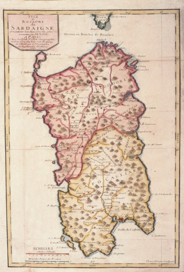
621-Novelle carte de l'Isle de Sardigne .
Map nautica and white representing the XIII table Atlas boat Michelot and Bremond. The title is placed at the Centre of Sardinia and is within a lable surmounted by the coat of arms of Louis XV. The map is enriched by 6 rose of the winds to 32-way. The card carries no indications on the island and offers only a few towns, towers coastal ponds and estuaries of major rivers
Author: Henri Michelot e Laurent Bremond
,1715 |
|
638-Baye de Cagliari .
Nautical Map of 1763that isura cm32x18 and it is found in the Petite Atlas Francois And' directed to South, the title is contained in a cartiglio and represents the gulf of Oristano and the damp zones of the southern Sinis.
Author: Joseph Roux
Marsiglia,1764 |
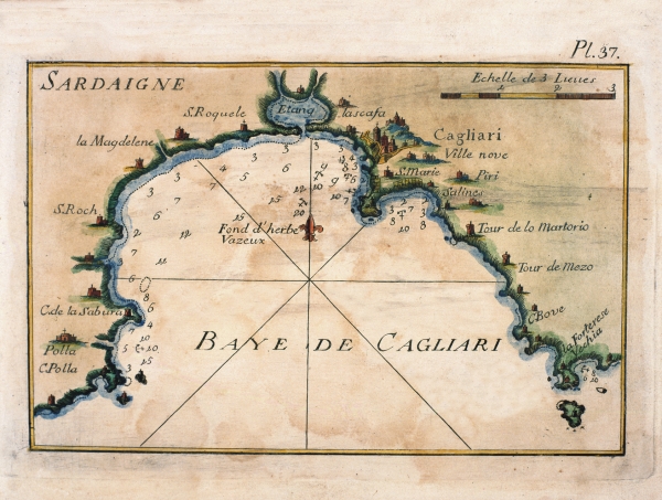
|
628-Sardiniae Regnum et Insula .
It is contained in the atlas "Isolario Geographical descrittione. Historica, Sacred-profane, Ancient-modern, Politics, Natural and Poetic. Seas, Gulfs, Breasts, Piagge, Brings, Boats, Peaches, Promontories, Mountains, Woods, Rivers, Lakes, Ponds, Baths, Volcani, Mines, Gems, Wealths and Coins; Iscrittioni, Languages, Governments, Armed Strengths, Wars, Alliances, Purchases, Losses, Truces, Treated of Peace, Claustral and Equestrian Religions, Concilj and Missions, Bishoprics, Archpriests and Patriarchies; Laws, Customs, Habiti, Coats of arms, Academies, Huomini Illustri and every most exact notitia of all the Islands Coll'osservationi of the rock-clifves, sirti, scagni, shoals of the globe terracqueo. Additional also the Drawn back de Dominators of them. Adorned of Three hundred-ten Geographical tables, Topographical, Corografiche, Iconografiche, Scenografiche, Idrografiche and Potamografiche. To great dilucidazione and use of the Navigatione. It is in supplement of the XIV Volumi of the Bleau. Tome II of the atlas Veneto. Work and study of the
Author: Vincenzo MariaCoronelli
Norimberga,1734 |
|
629-Carta Geografica della Isola di Sardegna .
The map is found In the work of Guillaume Delisle Atlas Novissimo that contains overall the parts of the momdo in which I/you/they am exactly descritti.stampato to Venice in the 1750. The crta derives from one of the Works of G. sanson
Author: Guillaume Sanson d'Abbeville
Venezia,1750 |
|
630-Le Royaume de Sardigne .
The map stamped in Paris in 1753 and the good cartographic document of the XVIII is considered secoloper how much it concerns the sardegna. And' note also as paper of the Piedmontese Engineers. Tall À a left is found unb cartiglio cn the tittolo and you/he/she is equipped by explanatory text.
Author: George Louis Le Rouge
Parigi,1753 |
|
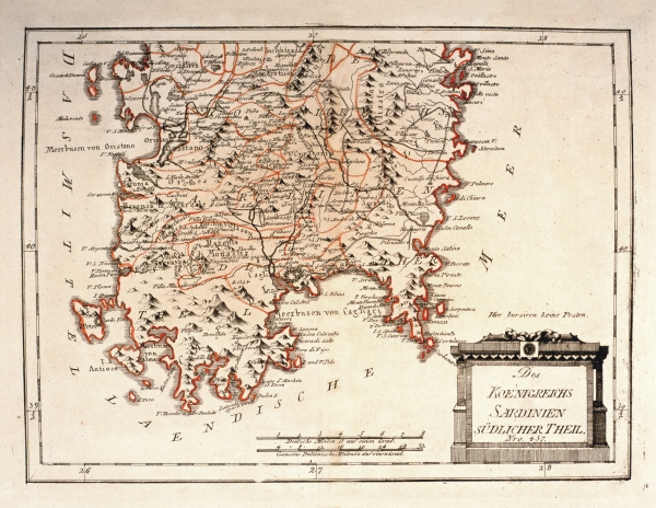
639- Des Koenigreichs Sardinien Sudlicher Theil .
Author: Franz Johann Joseph Von Reilly
Vienna,1789 |
|
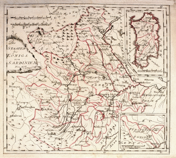
640-Die Staaten des Konigs von Sardinien .
This map, measuring 22,5 x 25,1 cm and printed in 1789 in Vienna, was drawn by Franz Johann Joseph von Reilly. It shows the Sardinian Kingdom's territory with the island in a square on the top right. At the bottom appears the Dukedom of Oneglia Genua. The title is on the left, the graphic scales are at the top. Author: Franz Johann Joseph Von Reilly
Vienna. PREZZO € 26.00,1789 |
|
644-Sardinia Insula .
The map is contained in the edition in Latin language of the atlas Guil. Et Ioannis Blaeu Theatrum Orbis terrarum sive Atlas Novus. Pars Tertia, Amsterdami Apud Ioh & Cornelium Blaeu 1640. L.atlante was given to the presses in 1640 to Amsterdam from Willem Janszoon Blaeu and you/he/she was republished in numerous editions, also after his/her death, edited by his/her children Joannis and Cornelium. The work is composed of 358 pages and you/he/she is equipped of 61 papers; that of Sardinia is found to page 109. The initial part is reserved to Italy, and he/she understands 220 pages, Greece and Great Britain follow, which 7 and 8 pages are respectively devoted
Author: Guilelmus e Ioannis Blaeu
Amsterdam,1640 |
|
645- L'Isola e Regno di Sardegna .
The map, that measures cm 54,7x39,1 and in the sketch cm 34,5x48,7, are found in the Arcane atlas of the Sea of D. Ruberto Dudleo, Duke of Nortumbria and count of Warvich - Tome according to, container the sixth book - In which deals with his/her Maps Geographical, and Particular second Impression, Correct, increased, according to the original one of the same Excellent Signor Duca, that preserves him in the bookstore of the convent in Florence of the Peace, de' Monks of St. Bernard of the order Fuliense. With the index of the Chapters, and of the Figures and Instructions to' Booksellers to tie her. To the serene Ferdinando Secondo Granduca of Tuscany In Fiorenza 1661 In the New Stamperia for Joseph Cocchini, to the Stella's insignia to appeal of Jacopo Bagnoni and Anton Francis Lucini With License de' Superior. The arcane one of the Sea was for the navigators of the epoch a fundamental text, because it brought entirely data new and new methodologies on the navigation, on the naval architecture, on the maritime discipline and mili
Author: Robert Dudley
,1646 |
|
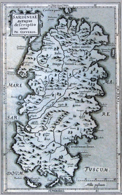
646- Sardinae Antiquae Descriptio .
The map is in the atlas Sicily Antiqua cum minoribus insulis ei adiacentibus item Sardinia et Corsica opus post omnium curas elaboratissimum, tabulis geographicis arc' expressis, illustratum. Ludguni Batavorum ex shop elseviriana. Year 1619.
Sardinia, represented to the table 3, you/he/she is accompanied by a description of the island equipped by many data and references of ancient authors that you/they have written some island. The map measures cm 20,5 xes 31,9 and in the sketch cm 28,4 xes 17,5, have been printed to Bologna in 1619 and it propose in the coastal profile of the island the formulation maginiana. The title, Sardiniae Antiquae descriptio, auctore Ph. Cluverio, is found to the left aloft in a situated quadrangular cartiglio, while in low to the right a graphic staircase of 40 millias is present passuum.
Author: Filippo Cluverio
Leyda,1619 |
|
647- Isola e Regno di Sardegna .
The map is in a composite volume that has as title Theater of the War and it is the n. 7 of a harvests of 11 colored presses. This document, that introduces aloft the North and it measures cm 64,6 xes 42,0 and in the sketch cm 61,5 xes 38,8, are part of a General Paper of Italy produced by unknown author at the end of the XVIII century; in the preserved volume in the library Casanatenses are present only some of the ten presses that compose this work, among which the first one represents western Sicily, and the second proposes a part of that oriental and of Calabria and contains a Table of the Longitude and Latitude of the places of the present paper fixed on the most recent astronomic observations and the indication that You latitude is taken by the first meridian of the island of the iron.
Among the other ones they are present the followings data that, he/she is specified, they have fixed above geographical combinations.
Author: Antonio Zatta
Livorno,1752 |
|
648-Sardegna centrale e meridionale .
The map, that center-southern Sardinia represents, as the preceding one is in the volume Theater of the War, it is the n. 10 of the harvest and it belongs to the edition of the General Paper of Italy it dates to the presses in the typography of Anthony Zatta in the 1798.
The document derives from an incision in copper, it is color acquerellato, introduces aloft the North, measure cm 64,3 xes 41,8 and in the sketch cm 61,4 xes 386.
Of this paper another edition is known, in black and white of which the author is not known, that has done reference to the paper called of the Ingenieurses Piemontois published by her Rouge in 1753 for the realization; from this last you/he/she has proposed the simbologia and line the divisions of the feudal districts. The writing Sardinia is set in the tall part of the sketch, the left border is graduated, and introduces a sweaters grid trapezoidal.
On the left side they are present well 18 graphic staircases that pointed out the unities of measure of the principals been Italian and European.
Author: Antonio Zatta
Livorno,1788 |
|
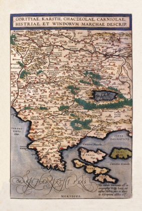
649-Goritiae, Karstii, Chacseolae, Carniolae, Historia et Windovum Marchae Descript. .
The map, that measures in the sketch cm 35,6 xes 23,5, is contained in the atlas Theatrum Orbis Terrarum of Abramo Ortelio, in the edition it dates to the presses in 1592 from the shop Plantiniana of Anversa. The document represents good part of western Slovenia and the Croazia Nord-occidentale with the Carso, l.Istria and the islands of the Quarnaro. The paper has been realized on the base of the jobs of Wolfgang Lazy and, as it regards the southern Istria with the data of another author not quoted. The islands are represented in schematic way and with an approximate sketch, with Vigil to West of Arbe instead that to North, North Cherso of Dislocates instead that to East; besides they have been neglected those smaller, despite is numerous a great deal. The island of Vigil (Vegia) is colored in pink, that of Arbe (Arbi) in brown dark color, Cherso (I will Dare) in brown clear and Dislocates (it Squeaks) in Rosa. The Map, graphically pleasant and very colored, introduces a rich orografia, with
Author: Abramo Ortelio
Anversa,0 |
|
650-Isola e Regno di Sardegna .
The Map, that measures cm 24,5 xes 17,5 and in the sketch cm 22 xes 26, are found in the volume 1° of the Italian Store that contains history (...) and other arts and sciences that can be of education and to like for every kind of people, The, Livorno 1752. of education and to like, a periodical printed edited by Anthony Santini and companions in great plaza to Livorno in July of the 1752.
The sketch of the island, inserted among graduated edges, it is of clear formulation maginiana, with the five great oriental inlets and the Gulf of Cagliari opened to East. The title is inserted in a cartiglio set to the right aloft and adorned by shoots of grapevine; in low to the left it is, it foresees the coat of arms of the Kingdom of Sardinia instead with the four, dark and, below, the graphic staircase in miles of Italy. The North is suitable from a lily set above a circle
Author: Antonio Santini
Livorno,1752 |
|
651-Carte nouvelle de l'Isale et royame de Sardagne .
It is contained in the atlas Nouveau Theatre of Italy Tom. III. contenant les Royaumes de Naples et de Sicile published to Amsterdam by Pierre Mortier in the 1704.
The atlas contains a harvest taken care of by the bookseller Pierre Mortier (1683 -1761), which used the papers stamped by Joannes Joan Blaeu (.1673), among which this paper of Nicola Sanson (.1667) was inclusive. The paper is graduated to the borders with a subdivision of 5' both for the latitude and for the longitude and it contains an inclusive space among 35°30' and 41°35' of latitude North and among 28°25' and 41°35' of East longitude from the meridian of the Green Head. In the paper the meridians and the parallels are brought and a rose of the winds is present with the North pointed out by a lily; every degree of latitude and longitude, is accompanied besides by the indication of a letter.
Author: Nicola Sanson
Amsterdam,1704 |
|
709-QUATTRO COFANETTI CARTE ANTICHE .
Author:
,0 |
|
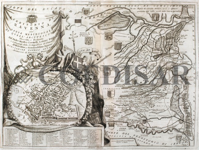
716 - TERRITORIO DI RAVENNA .
Author: Vincenzo Maria Coronelli
Venezia,1690 |
|
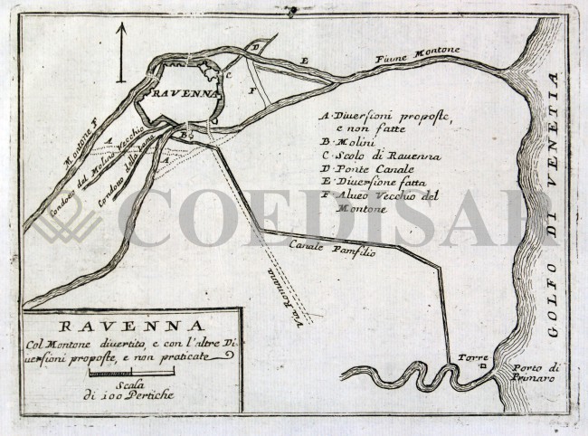
717 - Foce del Po e Ravenna .
Author: Vincenzo Maria Coronelli
Venezia,1596 |
|
755 - Sardegna .
Author: Ferdinando Bertelli
Venezia,1562 |
|
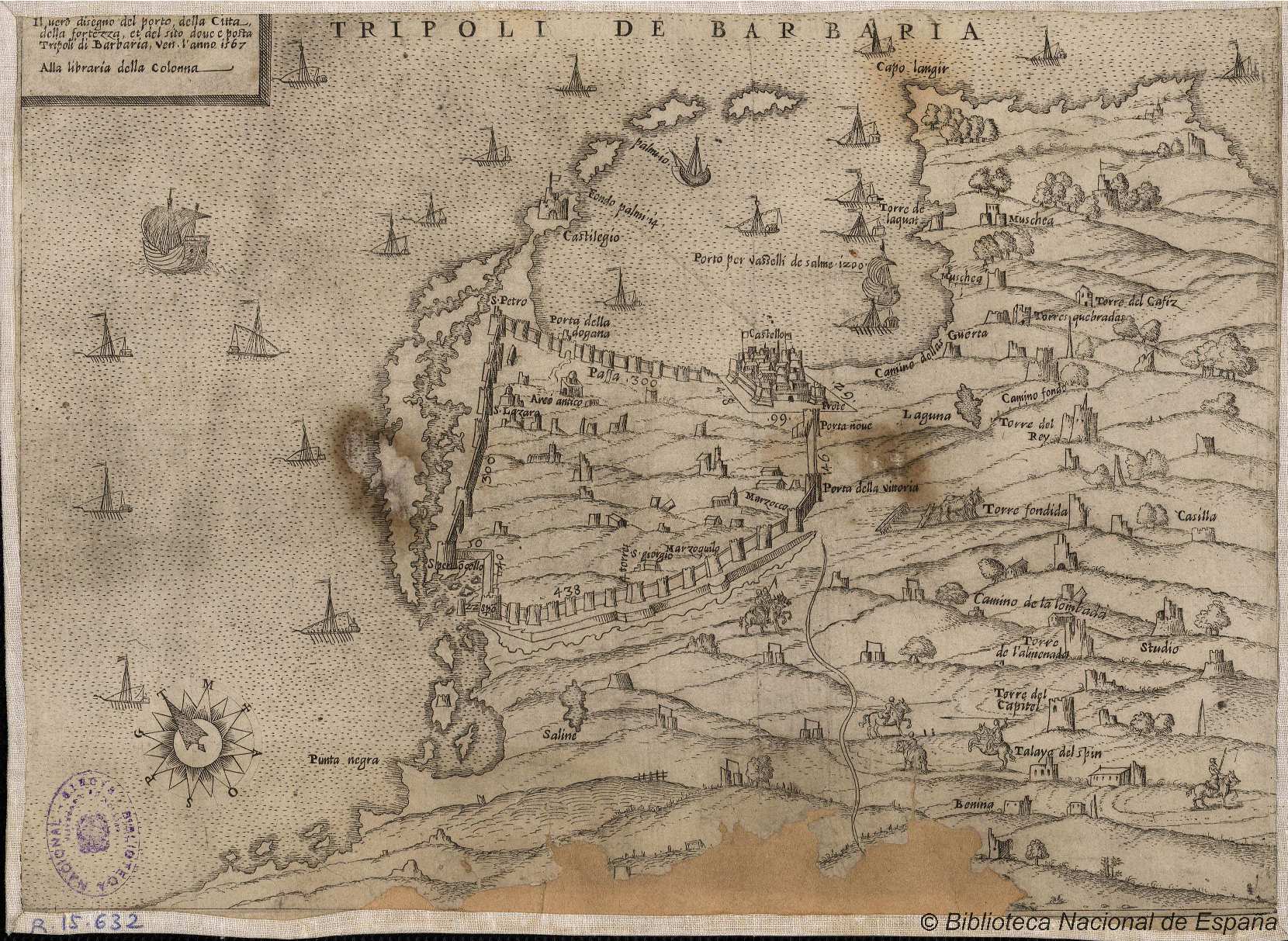
846- Tripoli de Barbaria .
Author:
,1567 |
|
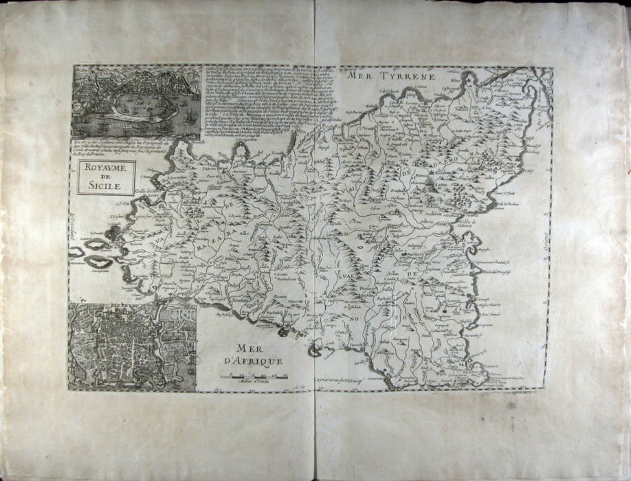
825-Royaume de Sicile .
Author:
Parigi,1674 |
|
817- Carta Isola e Regno di Sardegna .
Author: Alberto Lamarmora
Torino,1845 |
|
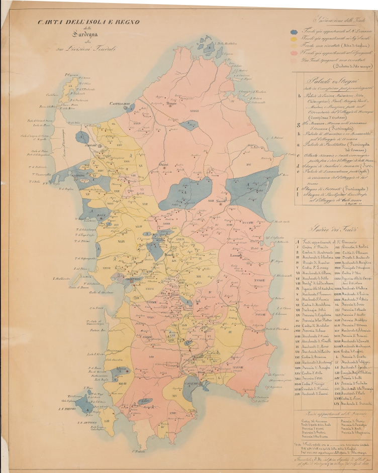
815- CARTA DELL’ISOLA E REGNO DELLA SARDEGNA COLLE SUE DIVISIONI FEU-DALI .
Author: Anonimo
Torino,0 |
|
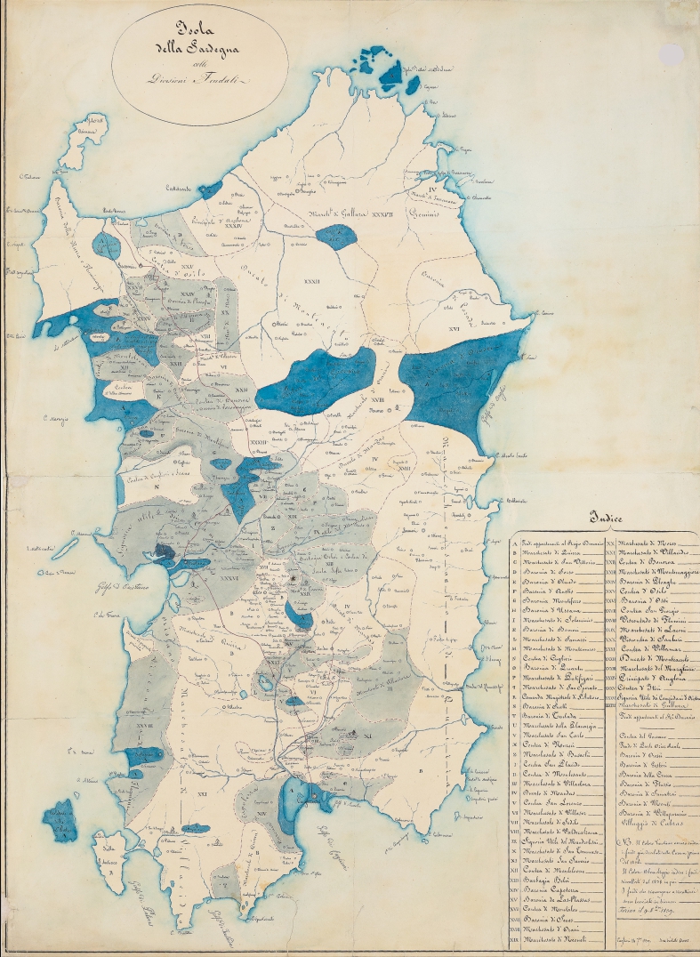
814- CARTA DELL’ISOLA E REGNO DELLA SARDEGNA COLLE DIVISIONI FEUDALI .
Author: Anonimo
Torino,0 |
|
809-Sardegna .
Author: Thomaso Porcacchi
Padova,1620 |
|
482-Sardegna .
Author: Matthäus Greuter
Venezia,1657 |
|
813- NUOVA CARTA DELL'ISOLA E REGNO DI SARDEGNA .
Author: Tommaso Napoli
Napoli,1811 |
|
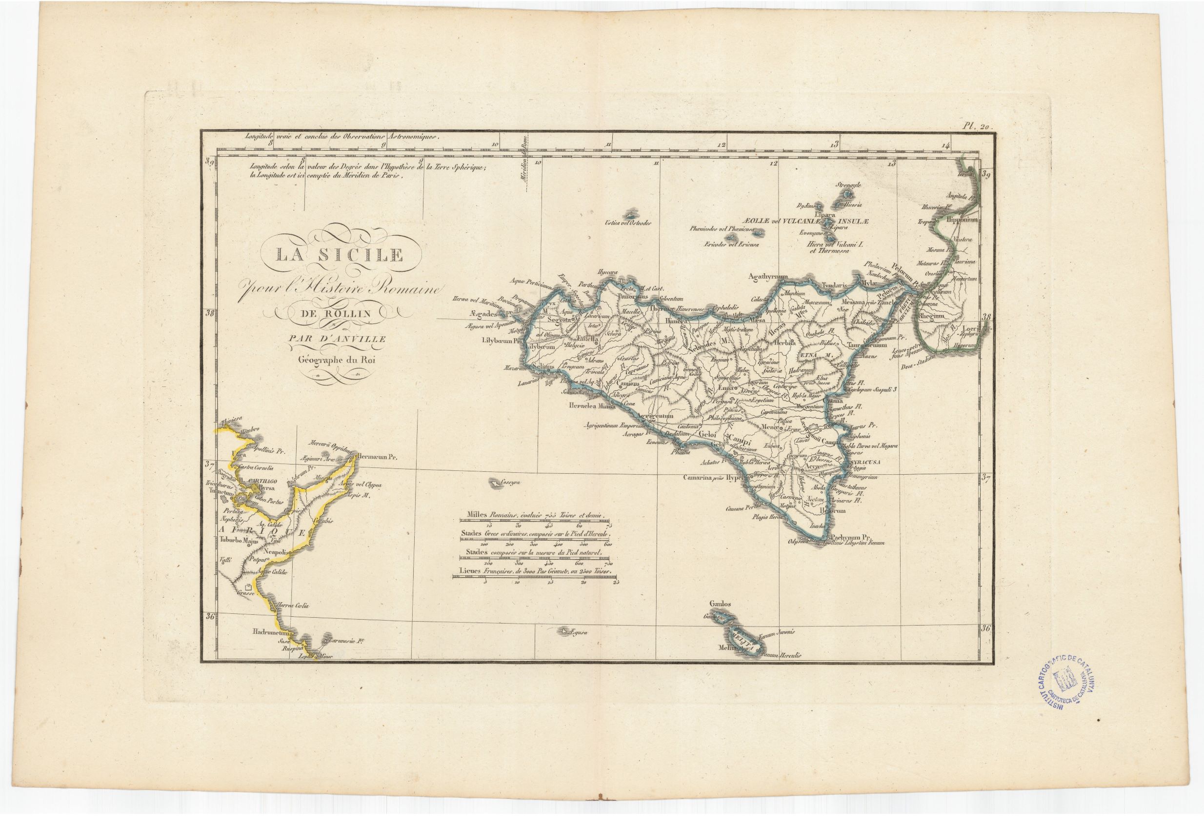
932- La Sicilie pour l'Histoire romaine de Rollin .
Author: Anville
,1760 |
|
931- Sardegna .
Author:
,1500 |

|
918-Die Insul oder das Kongsreich Sicilien .
Author: Stridbeck Junior
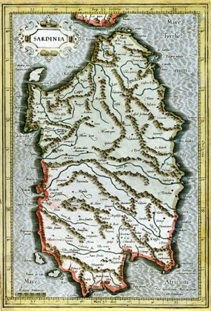
,1710 |
|
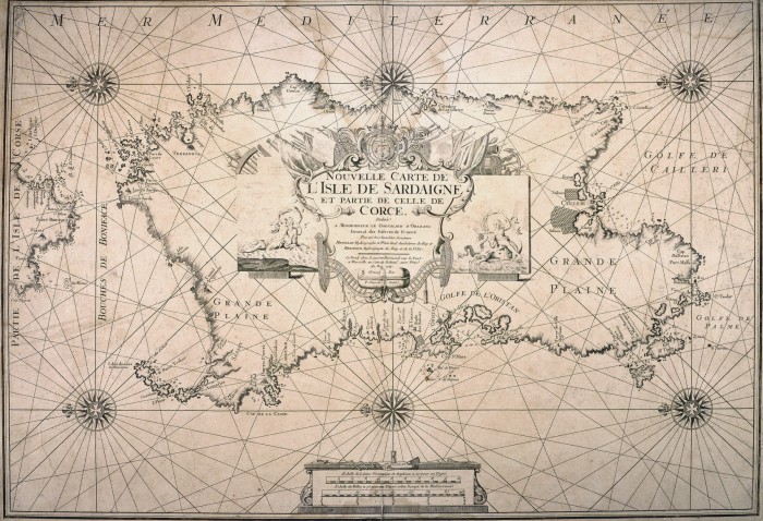
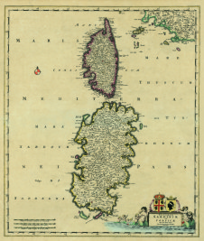
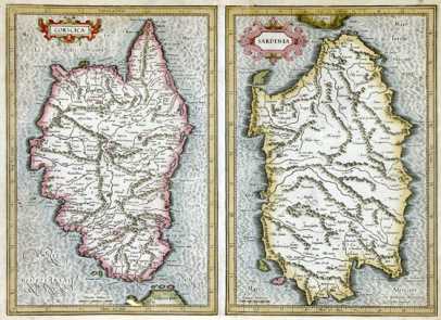
654 - Insularum Sardinia et Corsicae Descriptio .
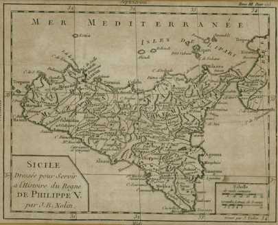
Author: Frederik De Witt
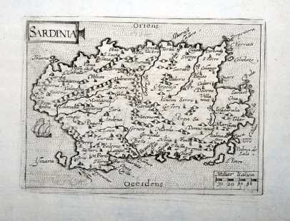
Amsterdam,0 |
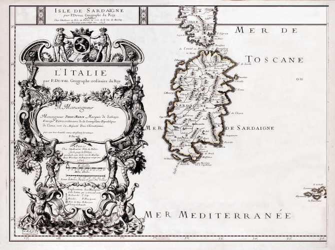
|
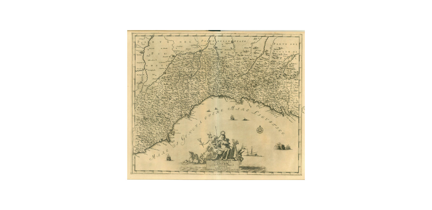
858-Carte de la Ligurie .
Author: Pieter Van Der Aa
,1729 |
|
857-Les environs de Rome .
Author: Pieter Van Der Aa
,1729 |

|
655- Isola di Sardegna .
Author: Giovanni Fileti
Palermo,1802 |
|
816-CARTA DELLA SARDEGNA RIDOTTA A 500 M .
Author: Arnoul
Parigi,1840 |
|
767-Sardinia .
Author: Gerardo Mercatore
Duisburg,1589 |
|
769 - Corsica et Sardinia .
Author: Gerardo Mercatore
Amsterdam,0 |
|
770 - Sicile .
Author: Jean Baptiste Nolin
Parigi,1702 |
|
771 -Sardinia .
Author: Cyprianus Eichovius
Colonia,1603 |
|
772 - Isle De Sardaigne .
Author: Pierre Du Val
Parigi,1675 |
|
773 - Karte von den Staaten des Königs von Sardinien .
Author: Daniel Friedrich Sotzmann
Berlino,1793 |
