![]()
![]()
![]()
![]()
![]()
![]()


MY MAPS
Regions:
![]()
Browse the website:
Latest Acquisitions
A Brief History of Cartography
The Cartographers
Events on ancient maps
Accimo editions
Brochure MB
Contacts
Glossary
Sitemap
|
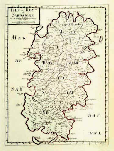
301-Isle et Royme de Sardaigne Description: The map measures 39 x 28,7 cm and belongs to the atlas N. Sanson d'Abbeville Cartes generales de toutes le parties du monde, ou les empires, monarchies, republiques, etats, peuples et de l'Asie, de l'Afrique, de l'Amerique sont exactement remarques et distinguèes suivant leur estenduè, Paris, l'autheur, P. Mariette, 1658 . Considering the longitude of the major Island, the scale is about 1:760 000. The margins are graduated and subdivided in 2'30''. The numeral values are marked from 10' to 10'. Autor: Nicola Sanson Place: Parigi Year: 1658 Quality document:
See online :
Go to verification |

See the printed version: Click here
