![]()
![]()
![]()
![]()
![]()
![]()


MY MAPS
Regions:
![]()
Browse the website:
Latest Acquisitions
A Brief History of Cartography
The Cartographers
Events on ancient maps
Accimo editions
Brochure MB
Contacts
Glossary
Sitemap
7 results
|
240-Friuli Venezia Giulia , Istria - Italia .
The map belongs to the Atlas sive Cosmographicae Meditationes de Fabrica Mundi et Fabricati Figura, published in 1644 in Duisburg.
Author: Gerardo Mercatore
Duisburg ,1644 |
|
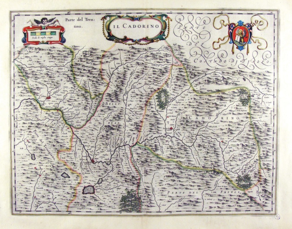
241-Il Cadorino - Friuli Venezia Giulia - Italia .
The Charter, which measures ' 49,7 x 38 is located in the Atlas Theatrum Orbis Terrarum sive Atlas Novus-tertia pars of Guilelmus et Ioannis Blaeu, printed in Amsterdam in the workshop of Giovanni Blaeu in 1650. The Charter represents the northern sector of Friuli, which borders the Tyrol.
Author: Ioannis Blaeu
Amsterdam ,1650 |
|
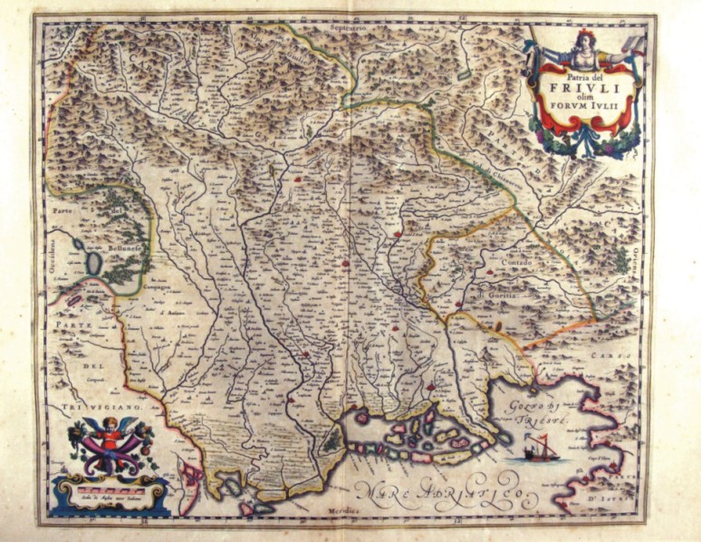
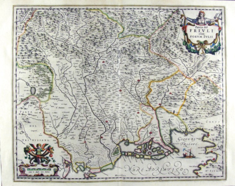
242-Patria del Friuli - Friuli Venezia Giulia - Italia .
The Charter, which measures ' 49,7 x 41 is located in the Atlas Theatrum Orbis Terrarum sive Atlas Novus-tertia pars of Guilelmus et Ioannis Blaeu, printed in Amsterdam in the workshop of Giovanni Blaeu in 1650. The card offers the North Eastern region of Italy between the Bellunese and karst with The countryside of Gorizia, part of Treviso, Trieste and its Gulf.
Author: Ioannis Blaeu
Amsterdam ,1650 |
|
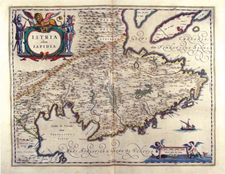
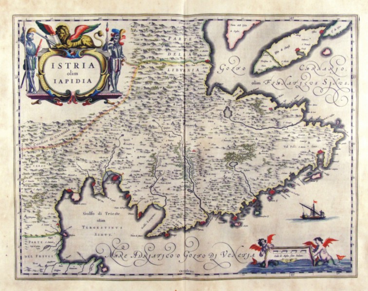
243-Istria olim Iapidia - Friuli Venezia Giulia - Italia .
The Charter, which measures ' 49,7 x 38 is located in the Atlas Theatrum Orbis Terrarum sive Atlas Novus-tertia pars of Guilelmus et Ioannis Blaeu, printed in Amsterdam in the workshop of Giovanni Blaeu in 1650. The Charter represents Istria with the Trieste Gulf to the West and the Gulf of Carnaro to East, with the town of Pula.
Author: Ioannis Blaeu
Amsterdam ,1650 |
|
244-Patria del Friuli - Friuli Venezia Giulia - Italia .
The Charter, which measures in the drawing ' 49.6 x 41 is contained in the Atlas Geographiae Blavianae volumen octavum Quo Italy quae est Europae Liber XVI of Blaeu printed in Amsterdam in 1662.
Author: Ioannis Blaeu
Amsterdam ,1662 |
|
245-Istria olim Iapidia - Friuli Venezia Giulia - Italia .
The Charter, which measures in the drawing cm 49,5 x 38.5, is contained in the Atlas Geographiae Blavianae volumen octavum Quo Italy quae est Europae Liber XVI of Blaeu printed in Amsterdam in 1662.
Author: Ioannis Blaeu
Amsterdam ,1662 |
|
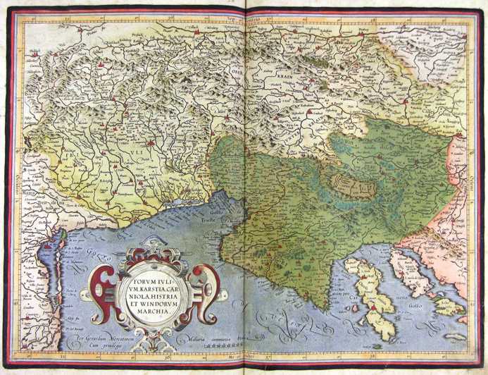
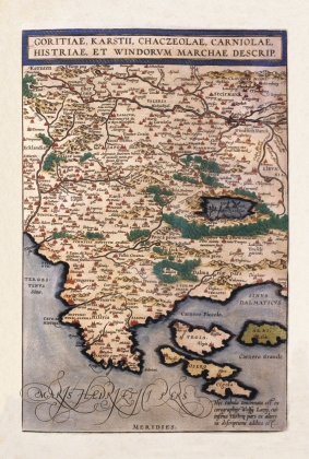
649-Goritiae, Karstii, Chacseolae, Carniolae, Historia et Windovum Marchae Descript. .
The map, that measures in the sketch cm 35,6 xes 23,5, is contained in the atlas Theatrum Orbis Terrarum of Abramo Ortelio, in the edition it dates to the presses in 1592 from the shop Plantiniana of Anversa. The document represents good part of western Slovenia and the Croazia Nord-occidentale with the Carso, l.Istria and the islands of the Quarnaro. The paper has been realized on the base of the jobs of Wolfgang Lazy and, as it regards the southern Istria with the data of another author not quoted. The islands are represented in schematic way and with an approximate sketch, with Vigil to West of Arbe instead that to North, North Cherso of Dislocates instead that to East; besides they have been neglected those smaller, despite is numerous a great deal. The island of Vigil (Vegia) is colored in pink, that of Arbe (Arbi) in brown dark color, Cherso (I will Dare) in brown clear and Dislocates (it Squeaks) in Rosa. The Map, graphically pleasant and very colored, introduces a rich orografia, with
Author: Abramo Ortelio
Anversa,0 |
