![]()
![]()
![]()
![]()
![]()
![]()


MY MAPS
Regions:
![]()
Browse the website:
Latest Acquisitions
A Brief History of Cartography
The Cartographers
Events on ancient maps
Accimo editions
Brochure MB
Contacts
Glossary
Sitemap
|
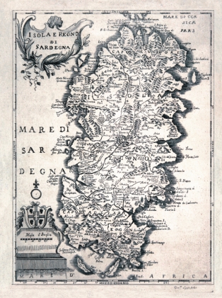
650-Isola e Regno di Sardegna Description: The Map, that measures cm 24,5 xes 17,5 and in the sketch cm 22 xes 26, are found in the volume 1° of the Italian Store that contains history (...) and other arts and sciences that can be of education and to like for every kind of people, The, Livorno 1752. of education and to like, a periodical printed edited by Anthony Santini and companions in great plaza to Livorno in July of the 1752. The sketch of the island, inserted among graduated edges, it is of clear formulation maginiana, with the five great oriental inlets and the Gulf of Cagliari opened to East. The title is inserted in a cartiglio set to the right aloft and adorned by shoots of grapevine; in low to the left it is, it foresees the coat of arms of the Kingdom of Sardinia instead with the four, dark and, below, the graphic staircase in miles of Italy. The North is suitable from a lily set above a circle Autor: Antonio Santini Place: Livorno Year: 1752 Quality document:
See online :
Go to verification |

See the printed version: Click here
