![]()
![]()
![]()
![]()
![]()
![]()


MY MAPS
Regions:
![]()
Browse the website:
Latest Acquisitions
A Brief History of Cartography
The Cartographers
Events on ancient maps
Accimo editions
Brochure MB
Contacts
Glossary
Sitemap
|
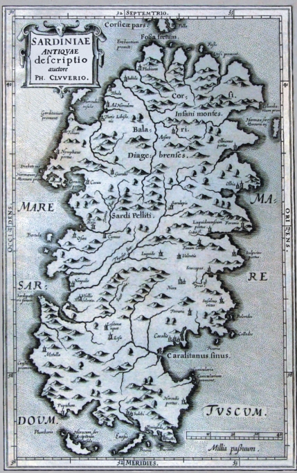
646- Sardinae Antiquae Descriptio Description: The map is in the atlas Sicily Antiqua cum minoribus insulis ei adiacentibus item Sardinia et Corsica opus post omnium curas elaboratissimum, tabulis geographicis arc' expressis, illustratum. Ludguni Batavorum ex shop elseviriana. Year 1619. Sardinia, represented to the table 3, you/he/she is accompanied by a description of the island equipped by many data and references of ancient authors that you/they have written some island. The map measures cm 20,5 xes 31,9 and in the sketch cm 28,4 xes 17,5, have been printed to Bologna in 1619 and it propose in the coastal profile of the island the formulation maginiana. The title, Sardiniae Antiquae descriptio, auctore Ph. Cluverio, is found to the left aloft in a situated quadrangular cartiglio, while in low to the right a graphic staircase of 40 millias is present passuum. Autor: Filippo Cluverio Place: Leyda Year: 1619 Quality document:
See online :
Go to verification |

See the printed version: Click here
