![]()
![]()
![]()
![]()
![]()
![]()


MY MAPS
Regions:
![]()
Browse the website:
Latest Acquisitions
A Brief History of Cartography
The Cartographers
Events on ancient maps
Accimo editions
Brochure MB
Contacts
Glossary
Sitemap

|
12-Aquitania .
The map is found in the Atlas sive Cosmographicae Meditationes de Fabrica Mundi et Fabricati Figura, published to Duisburg in the 1611. Dimensions: cm 47,5 x 36,3 Author: Gerardo Mercatore
Duisburg. ,1611 |
|
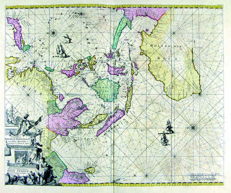
26-Oceania, Borneo e Australia .
The map is in the Atlas de la Navigation et du Commerce qui se fait dans touts the Parties du Monde, published in 1715 in Amsterdam. The map is decorated with a fine cartouche, from an exquisite engraving. Author: Louis Renard
Amsterdam. ,1715 |
|
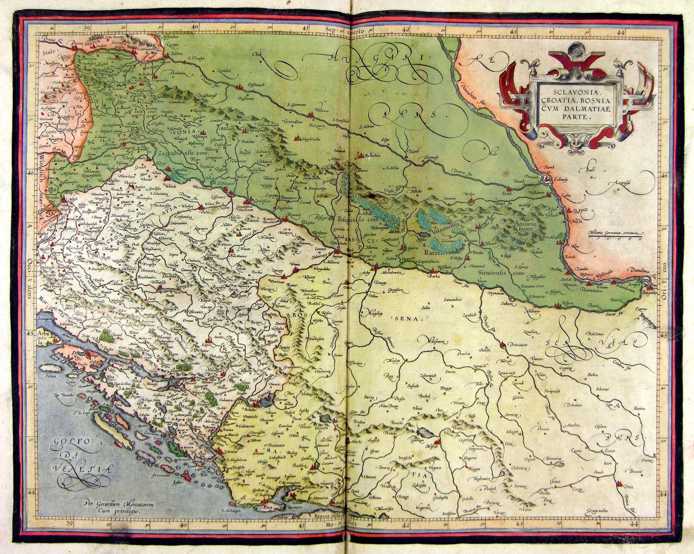
Slovenia, Croatia-Bosnia, cum Dalmatiae parte .
The document belongs to the Atlas sive Cosmographicae Meditationes de Fabrica Mundi et Fabricati Figura, published in 1644 in Duisburg. Dimensions: 47 x 37 cm. Author: Gerardo Mercatore
Duisburg. ,1644 |
|
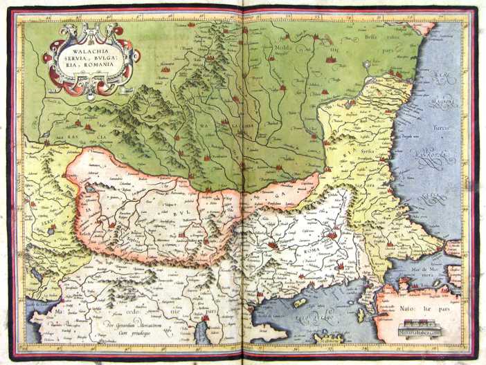
28-Walachia, Serbia, Bulgaria, Romania .
The document belongs to the Atlas sive Cosmographicae Meditationes de Fabrica Mundi et Fabricati Figura, published in 1644 in Duisburg. Dimensions : cm 47,5 x 35,8 Author: Gerardo Mercatore
Duisburg. ,1664 |
|
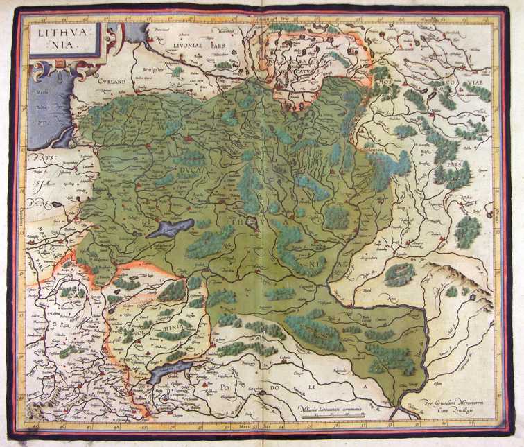
30-Lithuania - Lituania .
The map belongs to the Atlas sive Cosmographicae Meditationes de Fabrica Mundi et Fabricati Figura, published in 1644 in Duisburg. Dimensions: cm 45,3 x 38,5 Author: Gerardo Mercatore
Duisburg. ,1644 |
|
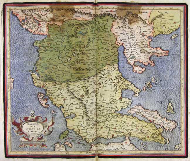
29-Macedonia, Epirus et Achaia .
The document belongs to the Atlas sive Cosmographicae Meditationes de Fabrica Mundi et Fabricati Figura, published in 1644 in Duisburg.
Dimensions : cm 43,5 x 36,8
Author: Gerardo Mercatore
Duisburg. ,1664 |
|
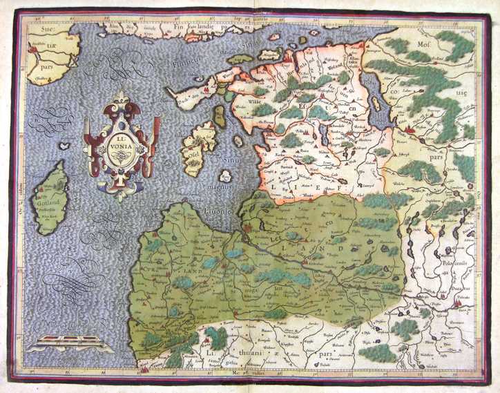
31-Livonia - Lettonia .
The map belongs to the Atlas sive Cosmographicae Meditationes de Fabrica Mundi et Fabricati Figura, published in 1644 in Duisburg. Dimensions : cm 48,5 x 36 Author: Gerardo Mercatore
Duisburg. ,1644 |
|
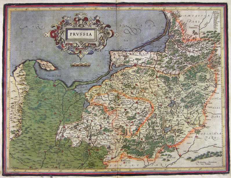
32-Prussia .
The map belongs to the Atlas sive Cosmographicae Meditationes de Fabrica Mundi et Fabricati Figura, published in 1644 in Duisburg. Dimensions : 50 x 37,5 cm Author: Gerardo Mercatore
Duisburg. ,1644 |
|
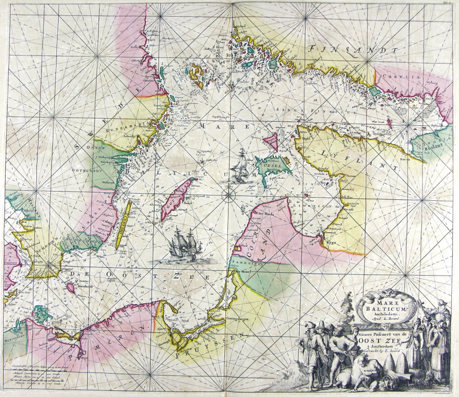
33-Mare Balticum - Mar Baltico .
The map belongs to the Atlas de la Navigation et du Commerce qui se fait dans toutes les Parties du Monde, published in 1715 in Amsterdam. The document has an elegant design taken from a precious engraving.
Dimensions : cm 57,5 x 49,5 Author: Louis Renard
Amsterdam. ,1715 |
|
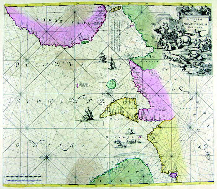
40-Russia e Nova Zemla .
The map belogs to the Atlas de la Navigation et du Commerce qui se fait dans toutes les Parties du Monde, published in 1715 in Amsterdam. It has an elegant design taken from a precious engraving. Dimensions : cm 56,5 x 50 Author: Louis Renard
Amsterdam. ,1715 |
|
41-Russia e Mar Nero .
The map belongs to the Atlas sive Cosmographicae Meditationes de Fabrica Mundi et Fabricati Figura, published in 1644 in Duisburg. Dimensions: 40,5 x 32 cm. Author: Gerardo Mercatore
Duisburg. ,1644 |
|
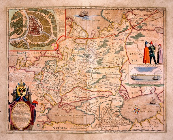
42-Russia .
The European Russia. A picture of Moscou by Fedori Borisowitsi appears at the top and a view of Archangelsckagoroda with a graphic scale in Germanic miles and three exotic figures are on the right. This map of 1614 is dedicated to Hesselo Gerardo and measures 54 x42,5cm. Author: Fedori Borisowitsi
,1614 |
|
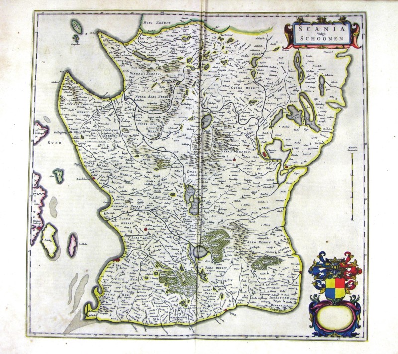
50-Scania - Svezia .
The map belongs to Geographia, quae est cosmographiae Blauianae pars prima, qua orbisterrae tabulis ante oculus ponitus et descriptionibus illustratur, published in 1665 in Amsterdam. Dimensions : cm 51 x 49,0 Author: Ioannis Blaeu
Amsterdam,1665 |
|
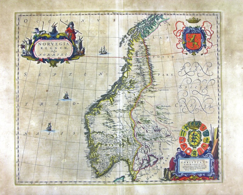
43-Norvegia Regnum - Norvegia .
The map belongs to Geographia, quae est cosmographiae Blauianae pars prima, qua orbisterrae tabulis ante oculus ponitus et descriptionibus illustratur, published in 1665 in Amsterdam. Dimensions: cm 49 x 40,6 Author: Ioannis Blaeu
Amsterdam,1665 |
|
44-Episcopatus Stavangriensis Pars Borealis - Norvegia .
The map belongs to Geographia, quae est cosmographiae Blauianae pars prima, qua orbisterrae tabulis ante oculus ponitus et descriptionibus illustratur, published in 1665 in Amsterdam. Dimensions : cm 50 x 36,4 Author: Ioannis Blaeu
Amsterdam,1665 |
|
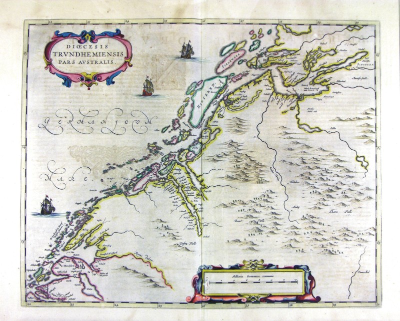
45-Diocesis Trundhemiensis - Norvegia .
The map belongs to Geographia, quae est cosmographiae Blauianae pars prima, qua orbisterrae tabulis ante oculus ponitus et descriptionibus illustratur, published in 1665 in Amsterdam. Dimensions : cm 52,5 x 41,9 Author: Ioannis Blaeu
Amsterdam,1665 |
|
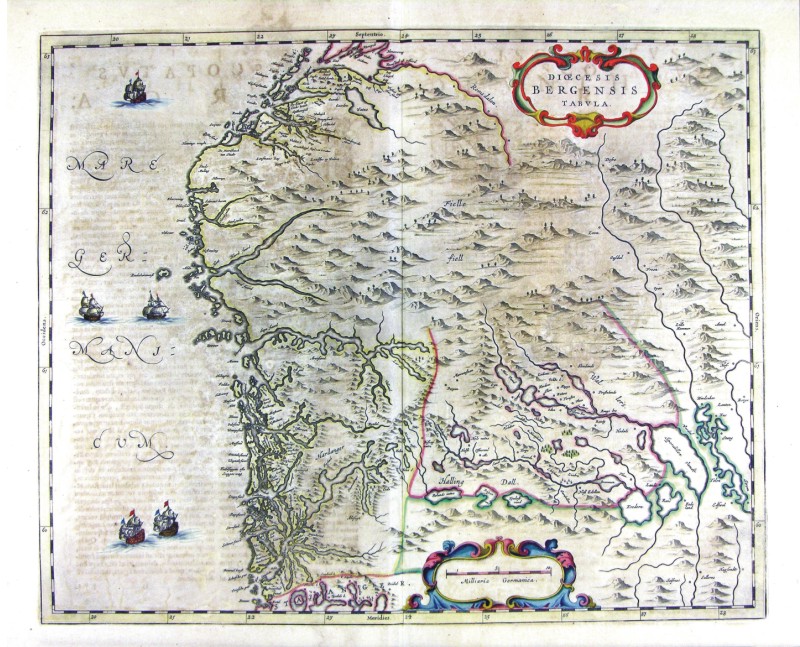
46-Diocesis Bergensis - Norvegia .
The map belongs to Geographia, quae est cosmographiae Blauianae pars prima, qua orbisterrae tabulis ante oculus ponitus et descriptionibus illustratur, published in 1665 in Amsterdam. Dimensions : cm 52,5 x 41 Author: Ioannis Blaeu
Amsterdam,1665 |
|
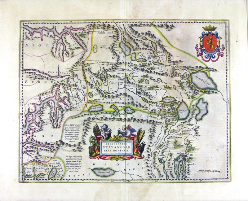
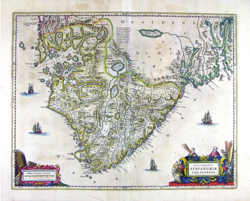
47-Episcopatus Stavangriae Pars Australis - Norvegia .
The map belongs to Geographia, quae est cosmographiae Blauianae pars prima, qua orbisterrae tabulis ante oculus ponitus et descriptionibus illustratur, published in 1665 in Amsterdam. Dimensions : cm 52,5 x 41 Author: Ioannis Blaeu
Amsterdam,1665 |
|
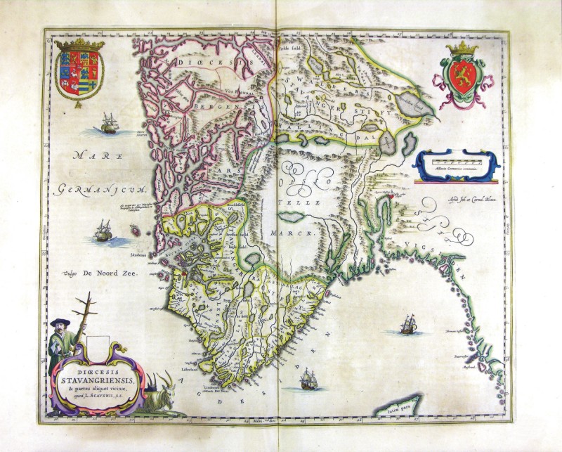
48-Diocesis Stavangriensis - Norvegia .
The map belongs to Geographia, quae est cosmographiae Blauianae pars prima, qua orbisterrae tabulis ante oculus ponitus et descriptionibus illustratur, published in 1665 in Amsterdam. Dimensions : cm 49,5 x 41,2 Author: Ioannis Blaeu
Amsterdam,1665 |
|
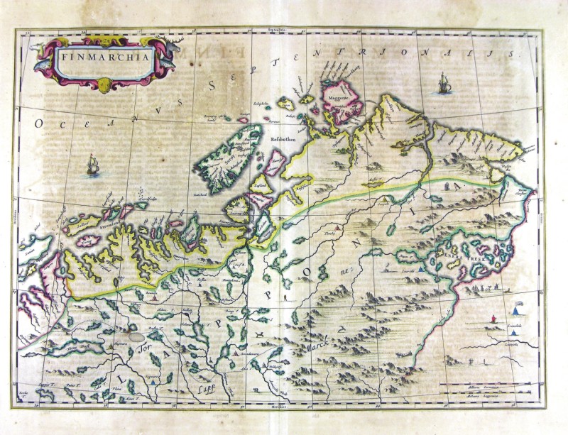
49-Finmarchia - Norvegia .
The map belongs to Geographia, quae est cosmographiae Blauianae pars prima, qua orbisterrae tabulis ante oculus ponitus et descriptionibus illustratur, published in 1665 in Amsterdam. Dimensions : cm 55 x 39,1 Author: Ioannis Blaeu
Amsterdam,1665 |
|
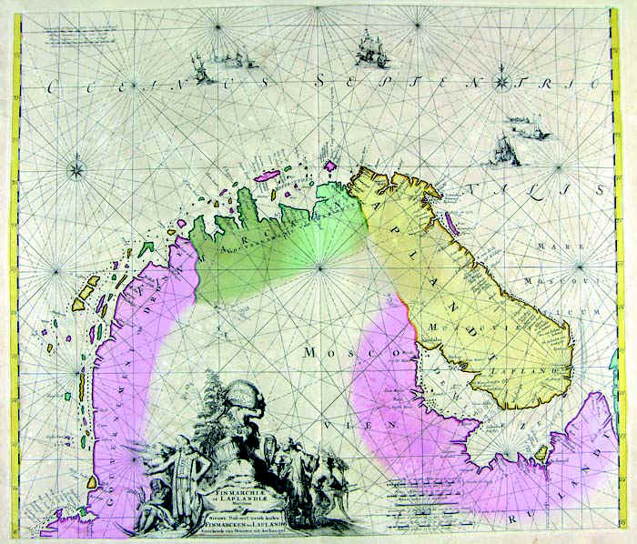
51-Finmarchia & Laplandia .
The document belongs to Atlas de la Navigation et du Commerce qui se fait dans toutes les Parties du Monde, published in 1715 in Amsterdam. Dimensions : cm 57,6 x 50 Author: Louis Renard
Amsterdam,1715 |
|
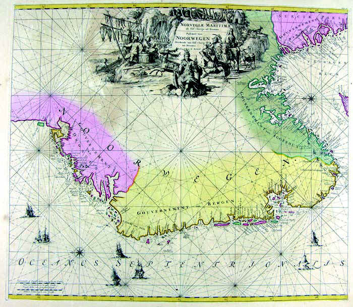
52-Norvegiae Maritima - Norvegia .
The document belongs to Atlas de la Navigation et du Commerce qui se fait dans toutes les Parties du Monde, published in 1715 in Amsterdam. Dimensions : cm 56,9 x 50 Author: Louis Renard
Amsterdam,1715 |
|
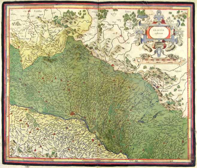
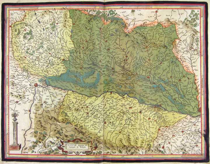
126-Alsazia inf. - Germania .
The map belongs to the Atlas sive Cosmographicae Meditationes de Fabrica Mundi et Fabricati Figura, published in 1611 in Duisburg. Author: Gerardo Mercatore
Duisburg,1611 |
|
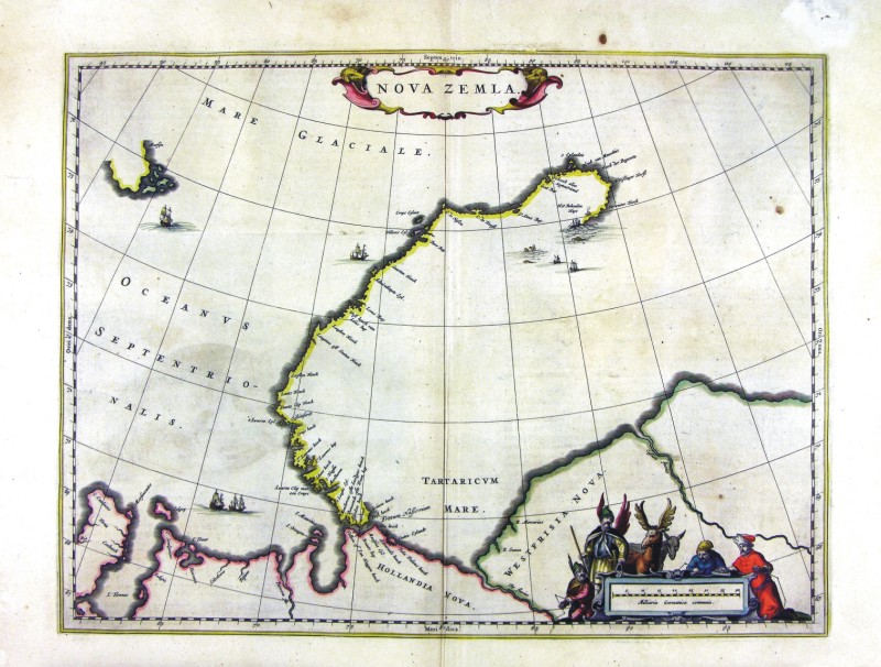
58-Nova Zemla .
The map belongs to the Geographia, quae est cosmographiae Blauianae pars prima, qua orbisterrae tabulis ante oculus ponitus et descriptionibus illustratur, published in 1665 in Amsterdam. Dimensions : cm 49,5 x 37,5 Author: Ioannis Blaeu
Amsterdam,1665 |
|
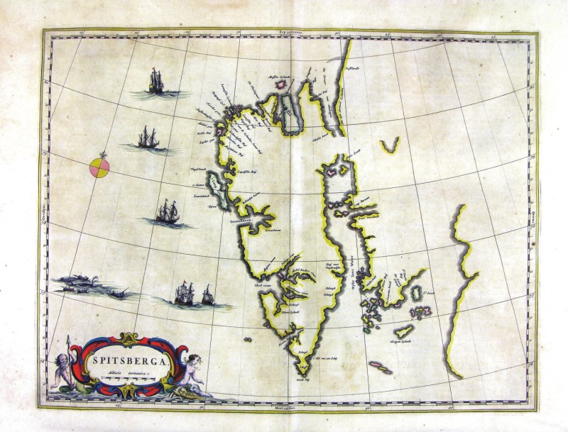
60-Spitsberga .
The map belongs to the Geographia, quae est cosmographiae Blauianae pars prima, qua orbisterrae tabulis ante oculus ponitus et descriptionibus illustratur, published in 1665 in Amsterdam. Dimensions : cm 48,5 x 36,8 Author: Ioannis Blaeu
Amsterdam,1665 |
|
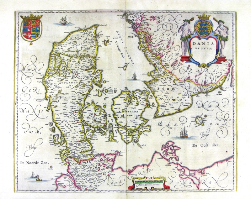
61-Dania Regnum - Danimarca .
The map belongs to the Geographia, quae est cosmographiae Blauianae pars prima, qua orbisterrae tabulis ante oculus ponitus et descriptionibus illustratur, published in 1665 in Amsterdam. Dimensions : cm 52 x 42 Author: Ioannis Blaeu
Amsterdam,1665 |
|
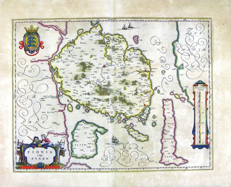
62-Fionia - Danimarca .
The map belongs to the Geographia, quae est cosmographiae Blauianae pars prima, qua orbisterrae tabulis ante oculus ponitus et descriptionibus illustratur, published in 1665 in Amsterdam. Dimensions : cm 49,5 x 37,5 Author: Ioannis Blaeu
Amsterdam,1665 |

|
63-Helgelandia - Danimarca .
The map belongs to the Geographia, quae est cosmographiae Blauianae pars prima, qua orbisterrae tabulis ante oculus ponitus et descriptionibus illustratur, published in 1665 in Amsterdam. Dimensions : cm 42,5 x 27,7 Author: Ioannis Blaeu
Amsterdam,1665 |
|
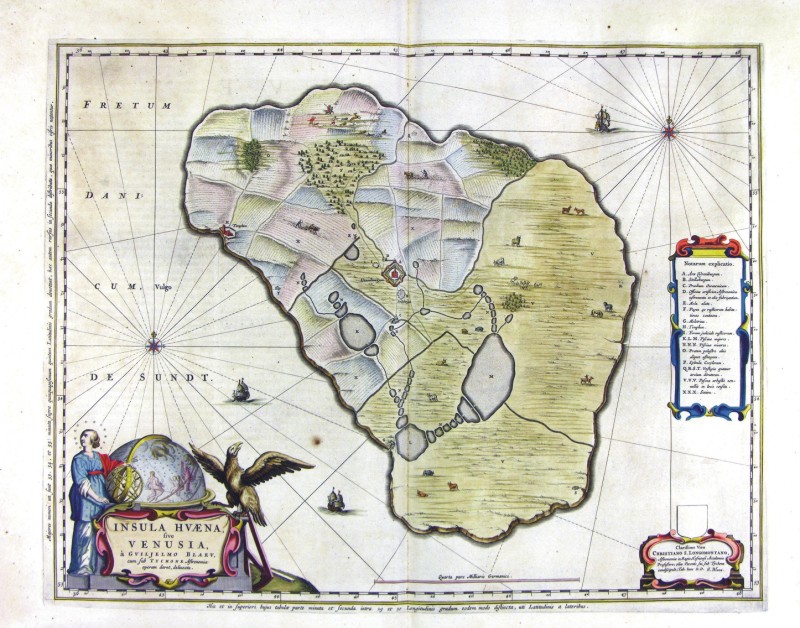
64-Insula Huaena five Venusia - Danimarca .
The map belongs to the Geographia, quae est cosmographiae Blauianae pars prima, qua orbisterrae tabulis ante oculus ponitus et descriptionibus illustratur, published in 1665 in Amsterdam. Dimensions : cm 52 x 40,8 Author: Ioannis Blaeu
Amsterdam,1665 |
|
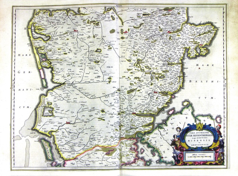
65-Pars Australior Iutiae Septentrionalis - Danimarca .
The map belongs to the Geographia, quae est cosmographiae Blauianae pars prima, qua orbisterrae tabulis ante oculus ponitus et descriptionibus illustratur, published in 1665 in Amsterdam. Dimensions : cm 57,5 x 47,8 Author: Ioannis Blaeu
Amsterdam,1665 |
|
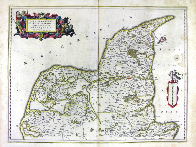
66-Pars Borealior Iutiae Septentrionalis - Danimarca .
The map belongs to the Geographia, quae est cosmographiae Blauianae pars prima, qua orbisterrae tabulis ante oculus ponitus et descriptionibus illustratur, published in 1665 in Amsterdam. Dimensions : cm 57 x 43,4 Author: Ioannis Blaeu
Amsterdam,1665 |
|
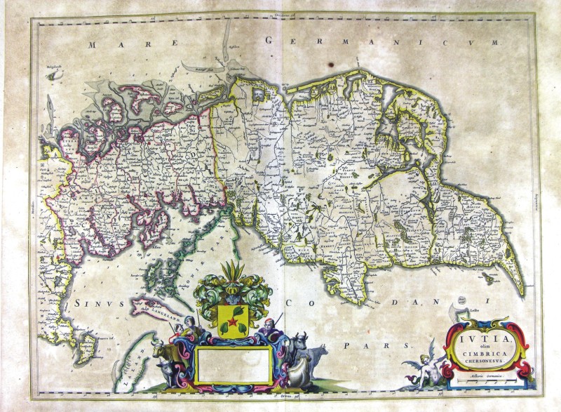
67-Iutia olim cimbrica chersonesus Danimarca .
The map belongs to the Geographia, quae est cosmographiae Blauianae pars prima, qua orbisterrae tabulis ante oculus ponitus et descriptionibus illustratur, published in 1665 in Amsterdam. Dimensions: cm 57,5 x 43 Author: Ioannis Blaeu
Amsterdam,1665 |
|
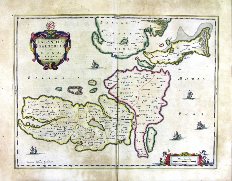
68-Lalandria, Falstria et Mona insule in Mare Baltico - Danimarca .
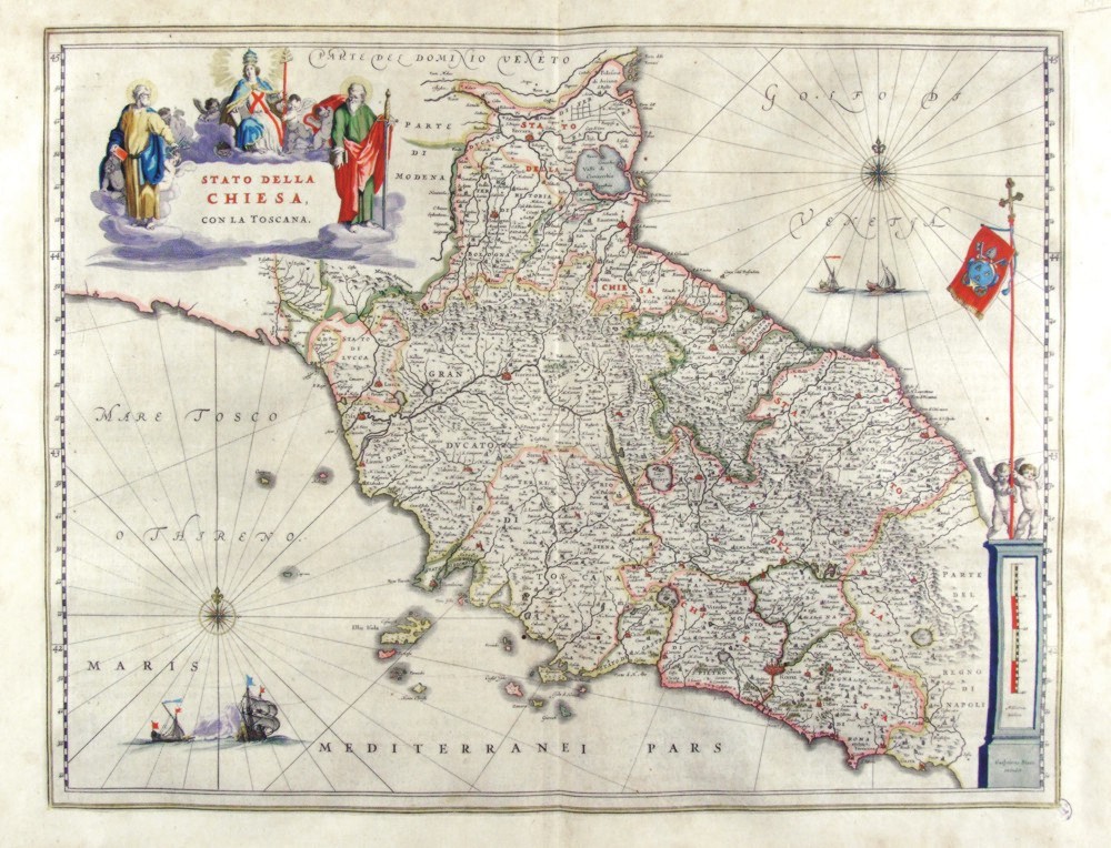
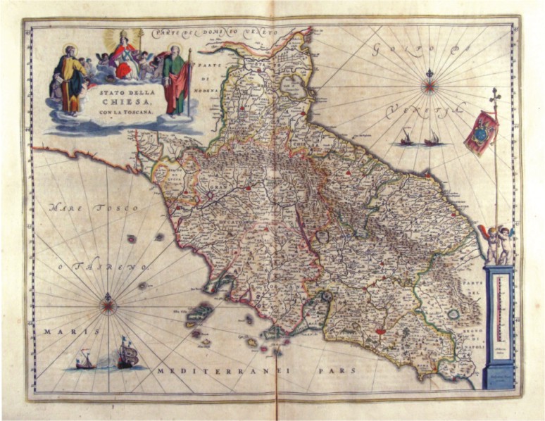
The map belongs to the Geographia, quae est cosmographiae Blauianae pars prima, qua orbisterrae tabulis ante oculus ponitus et descriptionibus illustratur, published in 1665 in Amsterdam. Dimensions : cm 51 x 38,5 Author: Ioannis Blaeu
Amsterdam,1665 |
|
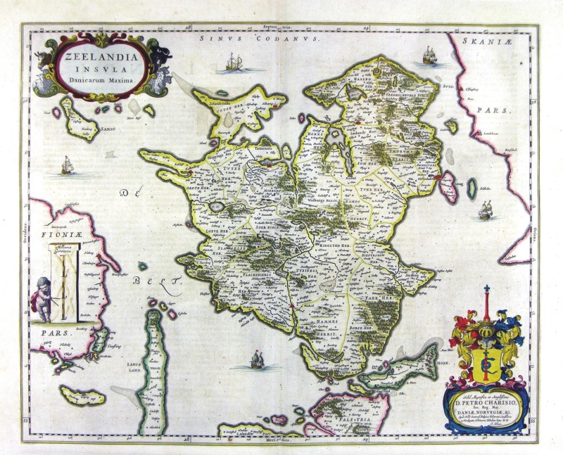
69-Zeelandia Insula - Danimarca .
The map belongs to the Geographia, quae est cosmographiae Blauianae pars prima, qua orbisterrae tabulis ante oculus ponitus et descriptionibus illustratur, published in 1665 in Amsterdam. Dimensions: cm 53,5 x 43,1 Author: Ioannis Blaeu
Amsterdam,1665 |
|
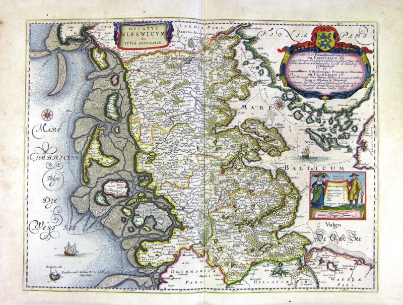
70-Ducatus Sleswici Iutia Australis - Danimarca .
The map belongs to the Geographia, quae est cosmographiae Blauianae pars prima, qua orbisterrae tabulis ante oculus ponitus et descriptionibus illustratur, published in 1665 in Amsterdam. Dimensions : cm 55 x 41,6 Author: Ioannis Blaeu
Amsterdam,1665 |
|
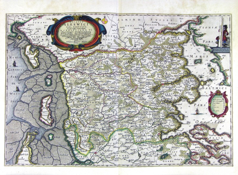
71-Ducatus Sleswici Pars Borealis - Danimarca .
The map belongs to the Geographia, quae est cosmographiae Blauianae pars prima, qua orbisterrae tabulis ante oculus ponitus et descriptionibus illustratur, published in 1665 in Amsterdam. Dimensions : cm 61 x 40,6 Author: Ioannis Blaeu
Amsterdam,1665 |
|
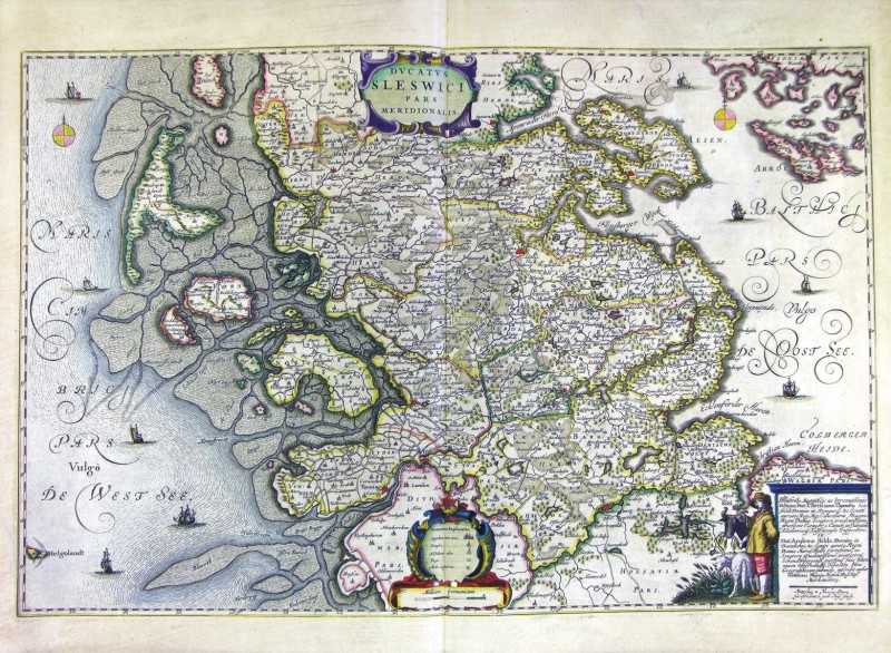
72-Ducatus Sleswici Pars Meridionalis - Danimarca .
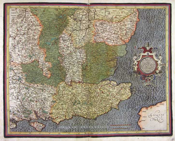
The map belongs to the Geographia, quae est cosmographiae Blauianae pars prima, qua orbisterrae tabulis ante oculus ponitus et descriptionibus illustratur, published in 1665 in Amsterdam. Dimensions : cm 61,5 x 40,2 Author: Ioannis Blaeu
Amsterdam,1665 |
|
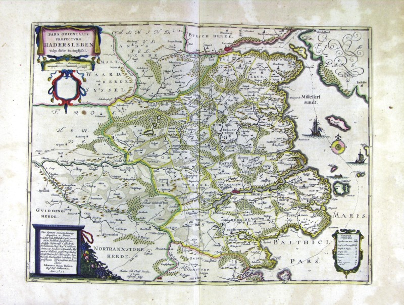
73-Pars Orientalis Praefecturae Hadersleben - Danimarca .
The map belongs to the Geographia, quae est cosmographiae Blauianae pars prima, qua orbisterrae tabulis ante oculus ponitus et descriptionibus illustratur, published in 1665 in Amsterdam. Dimensions: cm 53,5 x 39,7 Author: Ioannis Blaeu
Amsterdam,1665 |
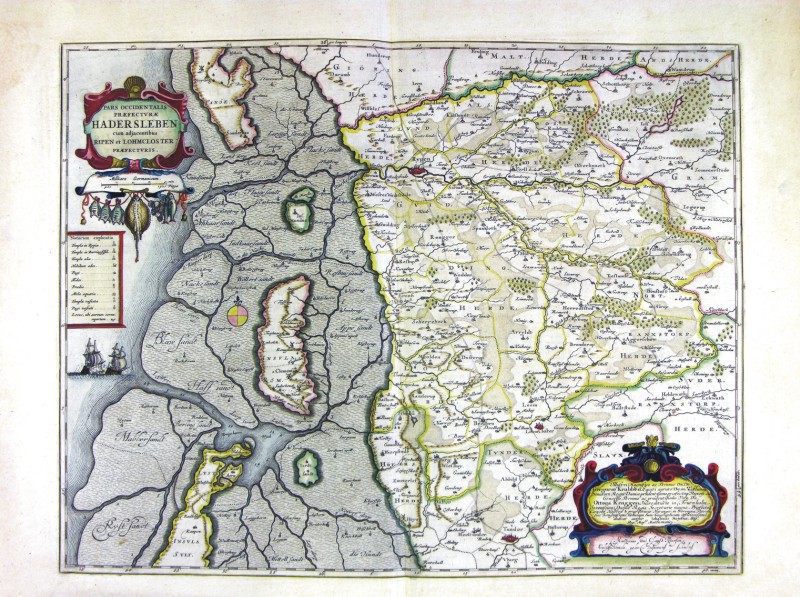
|
74-Pars Occidentalis Praefecturae Hadersleben - Danimarca .
The map belongs to the Geographia, quae est cosmographiae Blauianae pars prima, qua orbisterrae tabulis ante oculus ponitus et descriptionibus illustratur, published in 1665 in Amsterdam. Dimensions: cm 53 x 41,1 Author: Ioannis Blaeu
Amsterdam,1665 |
|
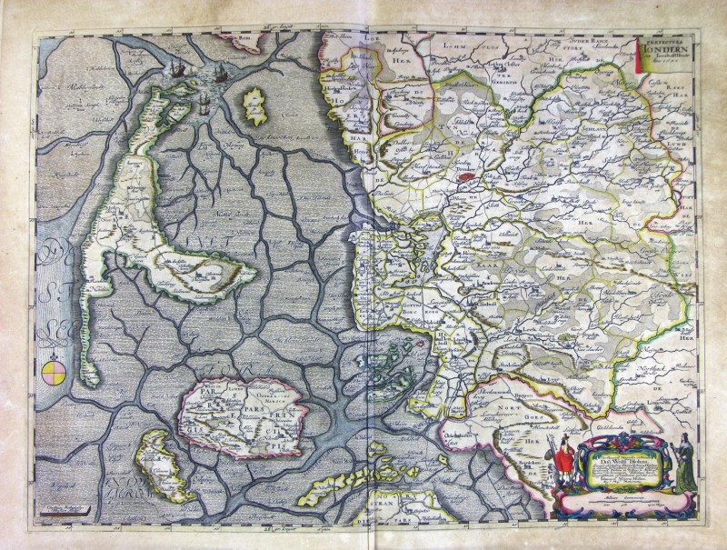
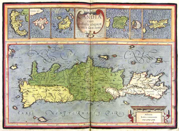
75-Prefetura Tondern - Danimarca .
The map belongs to the Geographia, quae est cosmographiae Blauianae pars prima, qua orbisterrae tabulis ante oculus ponitus et descriptionibus illustratur, published in 1665 in Amsterdam. Dimensions : cm 58 x 42,6 Author: Ioannis Blaeu
Amsterdam,1665 |
|
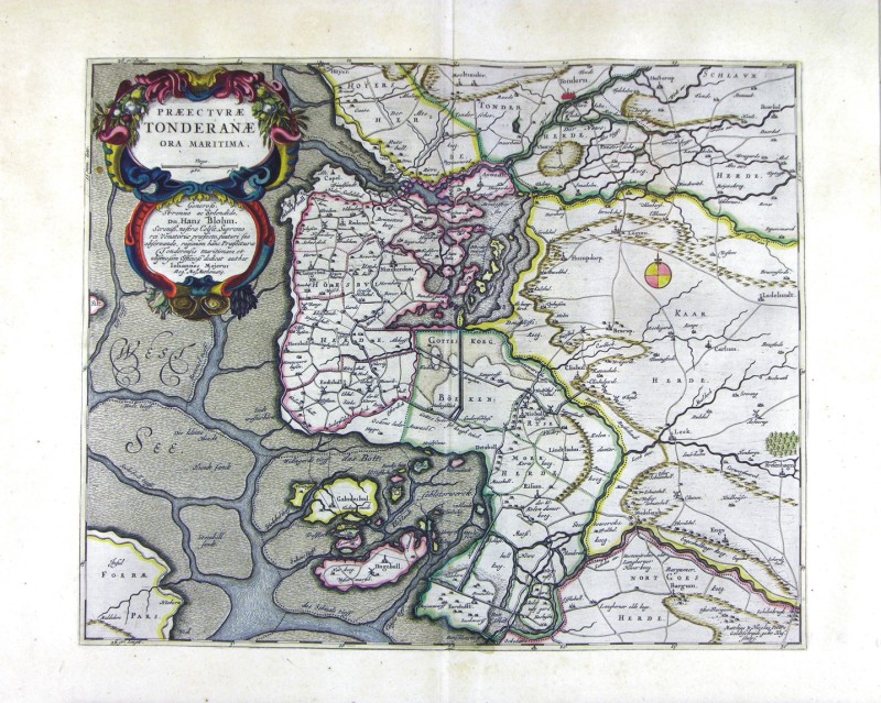
76-Prefetura Tonderane - Danimarca .
The map belongs to the Geographia, quae est cosmographiae Blauianae pars prima, qua orbisterrae tabulis ante oculus ponitus et descriptionibus illustratur, published in 1665 in Amsterdam. Dimensions : cm 48 x 38,7 Author: Ioannis Blaeu
Amsterdam,1665 |
|
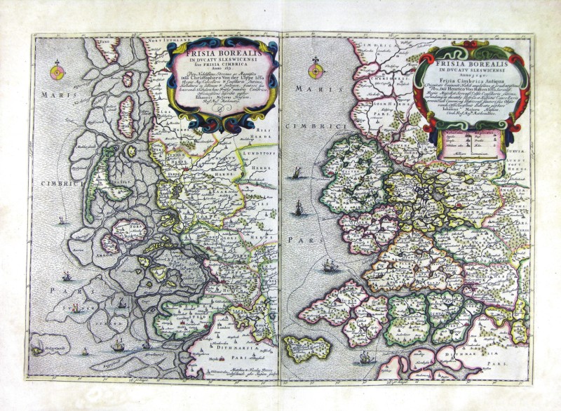
77-Frisia Borealis in Ducatus Sleswicensi - Danimarca .
The map belongs to the Geographia, quae est cosmographiae Blauianae pars prima, qua orbisterrae tabulis ante oculus ponitus et descriptionibus illustratur, published in 1665 in Amsterdam. Dimensions: cm 57 x 39,3 Author: Ioannis Blaeu
Amsterdam,1665 |
|
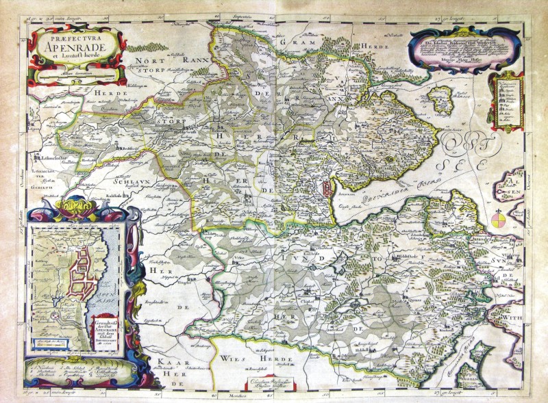
78-Praefetura Apenrade - Danimarca .
The map belongs to the Geographia, quae est cosmographiae Blauianae pars prima, qua orbisterrae tabulis ante oculus ponitus et descriptionibus illustratur, published in 1665 in Amsterdam. Dimensions: cm 60 x 44,7 Author: Ioannis Blaeu
Amsterdam,1665 |
|
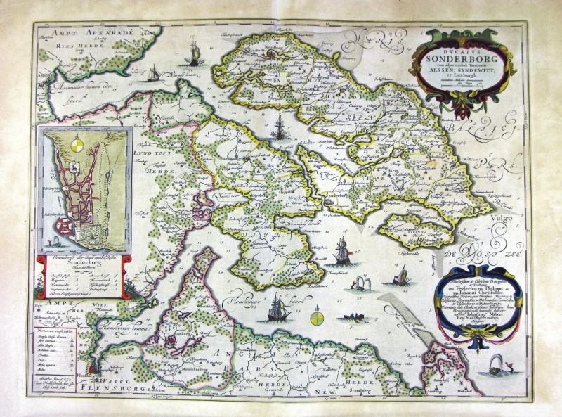
79-Ducatus Sonderborg - Danimarca .
The map belongs to the Geographia, quae est cosmographiae Blauianae pars prima, qua orbisterrae tabulis ante oculus ponitus et descriptionibus illustratur, published in 1665 in Amsterdam. Dimensions: cm 56,5 x 42,3 Author: Ioannis Blaeu
Amsterdam,1665 |
|
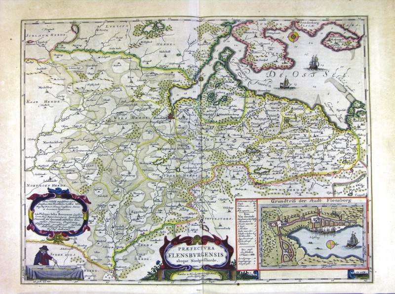
80-Praefetura Flensburgensis - Danimarca .
The map belongs to the Geographia, quae est cosmographiae Blauianae pars prima, qua orbisterrae tabulis ante oculus ponitus et descriptionibus illustratur, published in 1665 in Amsterdam. Dimensions: cm 56 x 42,6 Author: Ioannis Blaeu
Amsterdam,1665 |
|
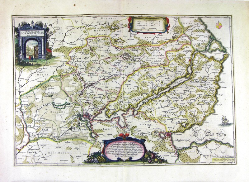
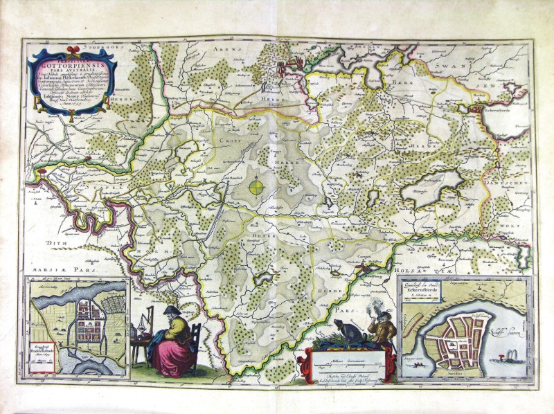
81-Praefetura Gottorpiensis - Danimarca .
The map belongs to the Geographia, quae est cosmographiae Blauianae pars prima, qua orbisterrae tabulis ante oculus ponitus et descriptionibus illustratur, published in 1665 in Amsterdam. Dimensions: cm 56,5 x 37,8 Author: Ioannis Blaeu
Amsterdam,1665 |
|
82-Praefetura Gottorpiensis pars Australis - Danimarca .
The map belongs to the Geographia, quae est cosmographiae Blauianae pars prima, qua orbisterrae tabulis ante oculus ponitus et descriptionibus illustratur, published in 1665 in Amsterdam. Dimensions: cm 59,5 x 40 Author: Ioannis Blaeu
Amsterdam,1665 |
|
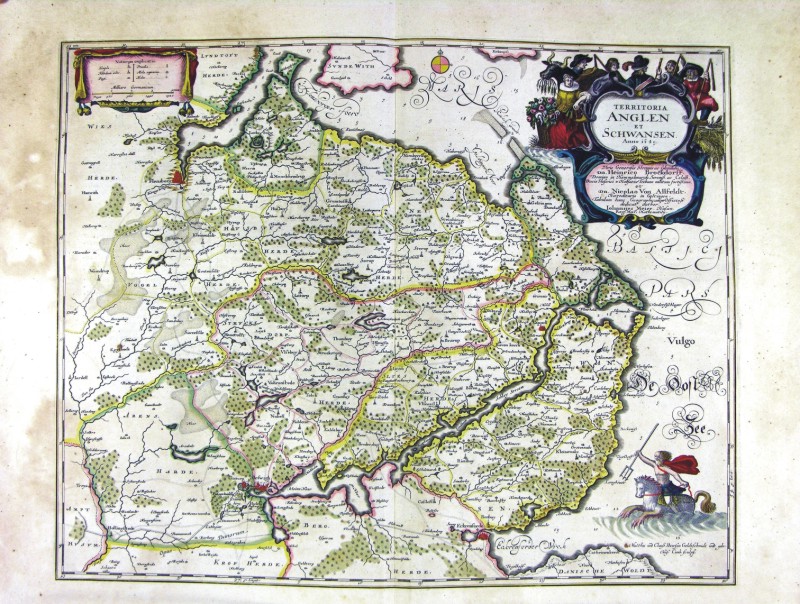
83-Territoriae Anglen et Schwansen - Danimarca .
The map belongs to the Geographia, quae est cosmographiae Blauianae pars prima, qua orbisterrae tabulis ante oculus ponitus et descriptionibus illustratur, published in 1665 in Amsterdam. Dimensions : cm 53 x 42 Author: Ioannis Blaeu
Amsterdam,1665 |
|
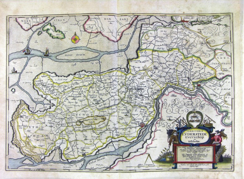
84-Territoriae Eyderstede, Everschop et Uthholm - Danimarca .
The map belongs to the Geographia, quae est cosmographiae Blauianae pars prima, qua orbisterrae tabulis ante oculus ponitus et descriptionibus illustratur, published in 1665 in Amsterdam. Dimensions : cm 61 x 42,3 Author: Ioannis Blaeu
Amsterdam,1665 |
|
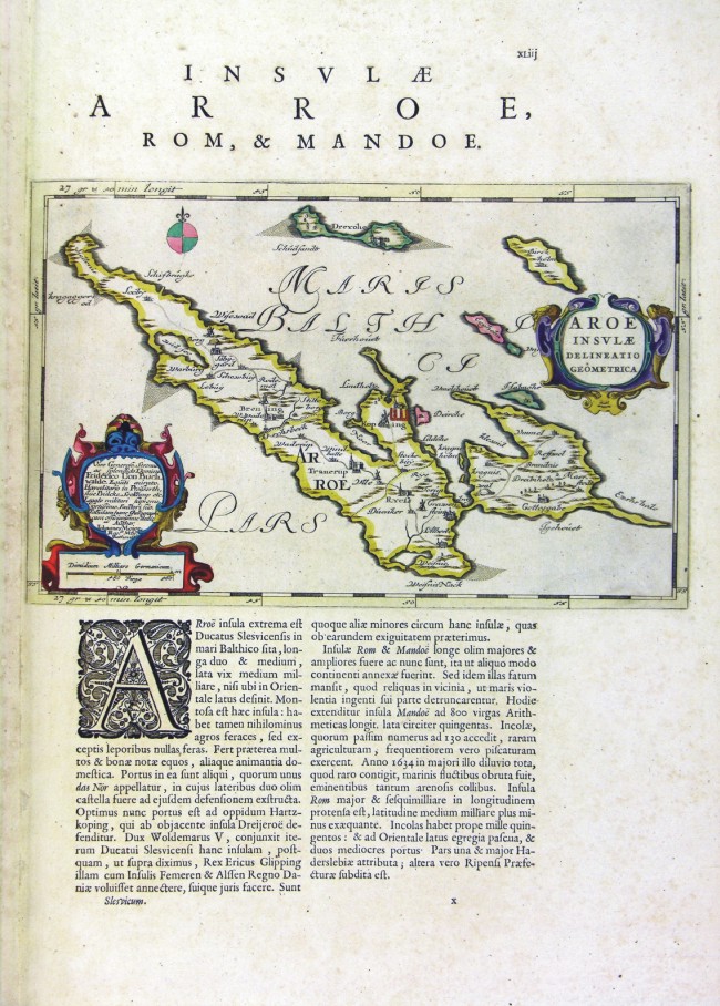
85-Aroae Insulae - Danimarca .
The map belongs to the Geographia, quae est cosmographiae Blauianae pars prima, qua orbisterrae tabulis ante oculus ponitus et descriptionibus illustratur, published in 1665 in Amsterdam. Dimensions : cm 30,2 x 19,5 Author: Ioannis Blaeu
Amsterdam,1665 |
|
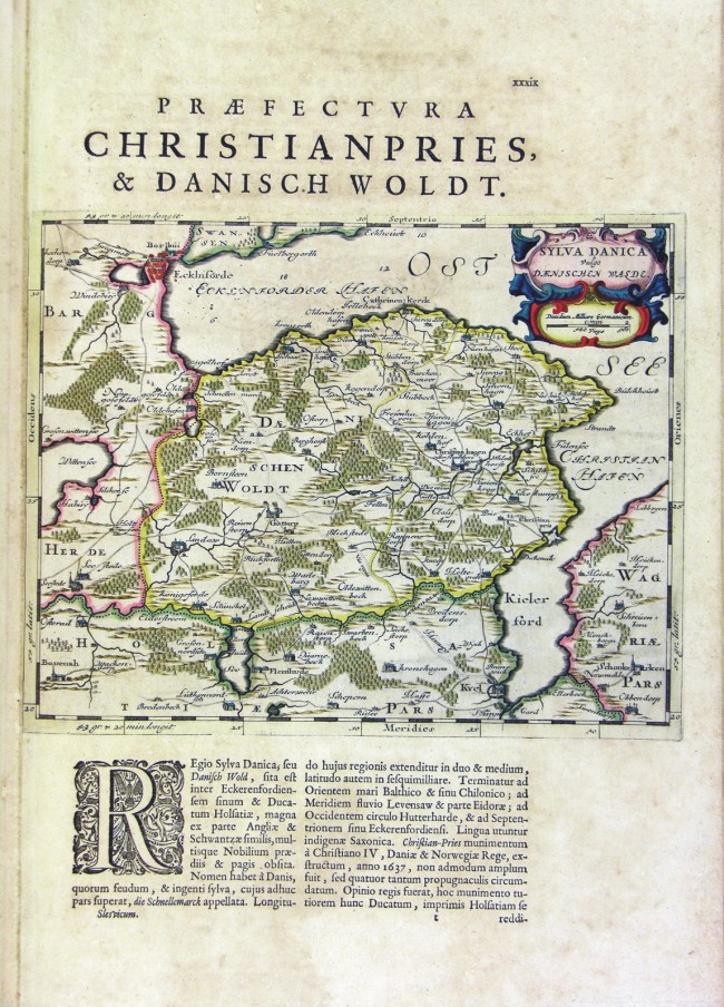
86-Sylva Danica - Danimarca .
The map belongs to the Geographia, quae est cosmographiae Blauianae pars prima, qua orbisterrae tabulis ante oculus ponitus et descriptionibus illustratur, published in 1665 in Amsterdam. Dimensions : cm 49,5 x 37,5 Author: Ioannis Blaeu
Amsterdam,1665 |
|
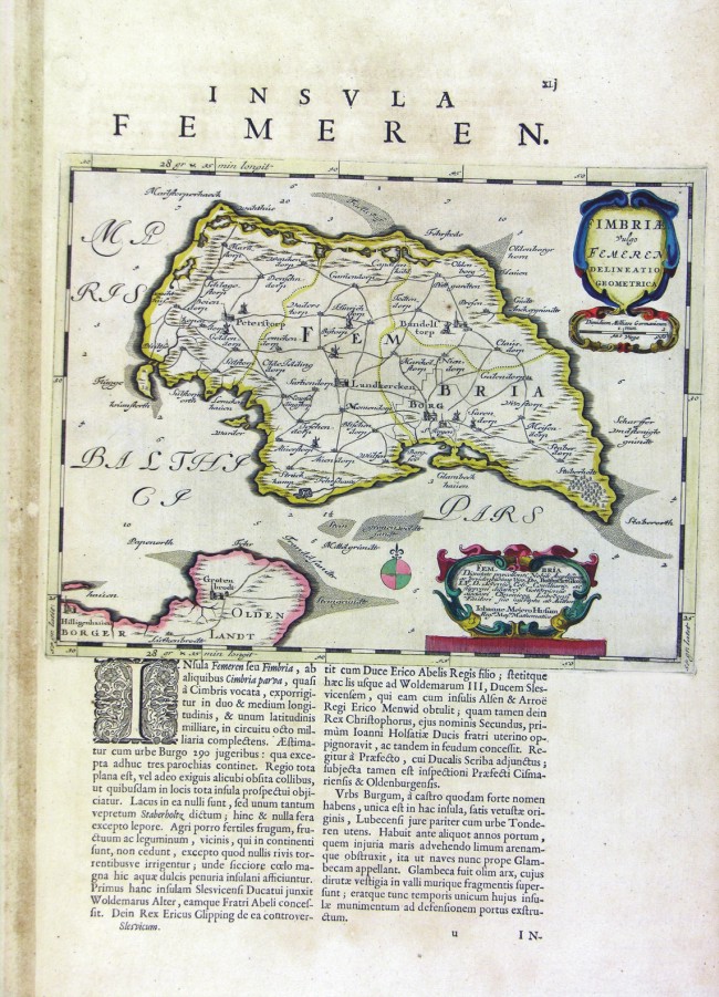
87-Fimbria - Danimarca .
The map belongs to the Geographia, quae est cosmographiae Blauianae pars prima, qua orbisterrae tabulis ante oculus ponitus et descriptionibus illustratur, published in 1665 in Amsterdam. Dimensions: cm 29,4 x 23 Author: Ioannis Blaeu
Amsterdam,1665 |
|
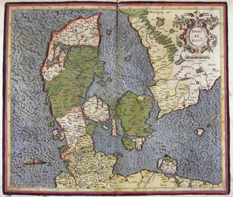
88-Dania Regnum - Danimarca .
The map belongs to the Atlas sive Cosmographicae Meditationes de Fabrica Mundi et Fabricati Figura, published in 1664 in Duisburg. Dimensions: 45,5 x 38,5 cm. Author: Gerardo Mercatore
Duisburg,1664 |
|
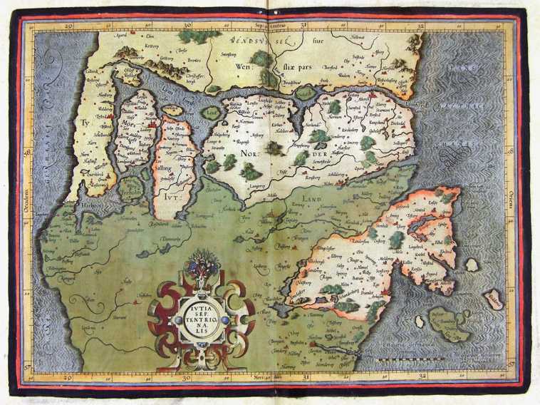
89-Yutia Septentrionalis - Danimarca .
The map belongs to the Atlas sive Cosmographicae Meditationes de Fabrica Mundi et Fabricati Figura, published in 1664 in Duisburg. Dimensions: cm 40,5 x 28,9 Author: Gerardo Mercatore
Duisburg,1664 |
|
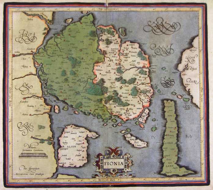
90-Fionia - Danimarca .
The map belongs to the Atlas sive Cosmographicae Meditationes de Fabrica Mundi et Fabricati Figura, published in 1664 in Duisburg. Dimensions : cm 41,8 x 37 Author: Gerardo Mercatore
Duisburg,1664 |
|
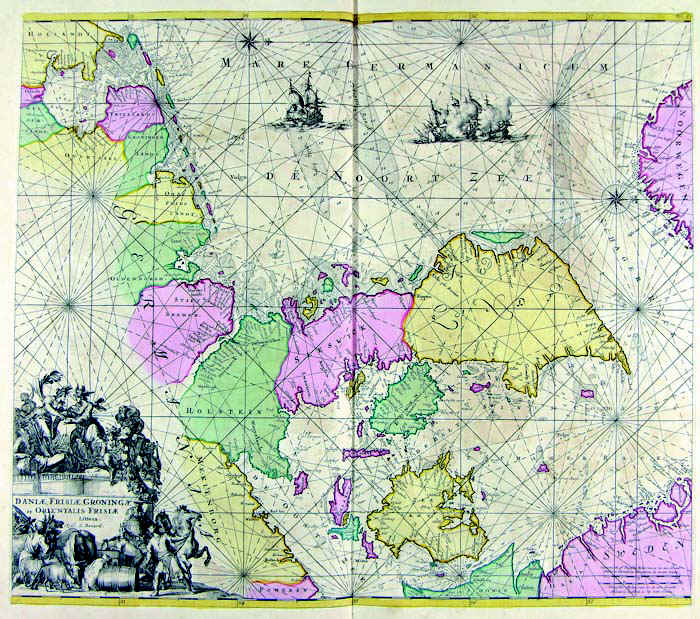
91-Dania, Frisia, Groningae et Orientalis Frisiae .
The map belongs to the Atlas de la Navigation et du Commerce qui se fait dans toutes les Parties du Monde, published in 1715 in Amsterdam. Dimensions: 56,8 x 50 cm. Author: Louis Renard
Amsterdam,1715 |
|
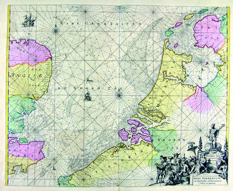
92-Mare Germanicum .
The map belongs to the Atlas de la Navigation et du Commerce qui se fait dans toutes les Parties du Monde, published in 1715 in Amsterdam. The document was taken from a precious engraving. Dimensions : cm 58,2 x 47 Author: Louis Renard
Amsterdam,1715 |
|
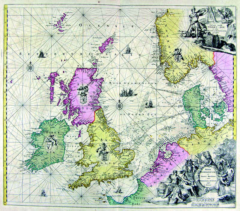
93-Inghilterra, Olanda, Danimarca .
The document belongs to the Atlas de la Navigation et du Commerce qui se fait dans toutes les Parties du Monde, published in 1715 in Amsterdam. The fine drawed map is decorated with two elegant pictures. Dimensions: 56,8 x 49,5 cm.
Author: Louis Renard
Amsterdam,1715 |
|
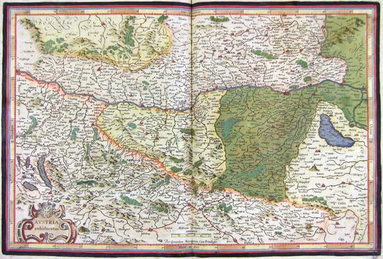
94-Austria .
The map belongs to the Atlas sive Cosmographicae Meditationes de Fabrica Mundi et Fabricati Figura, published in 1644 in Duisburg. Dimensions: 49,5 x 33,2 cm. Author: Gerardo Mercatore
Duisburg,1644 |

|
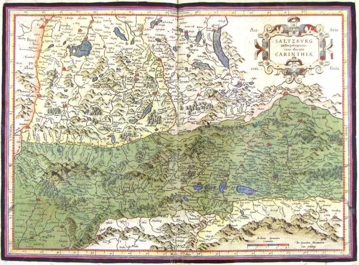
95-Salisburgo - Austria .
The map belongs to the Atlas sive Cosmographicae Meditationes de Fabrica Mundi et Fabricati Figura, published in 1644 in Duisburg. Author: Gerardo Mercatore
Duisburg,1644 |

|
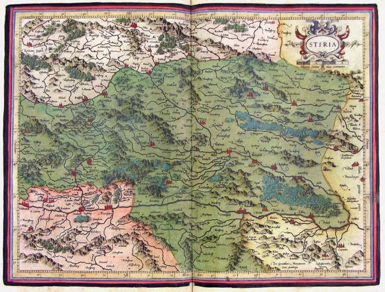
96-Stiria - Austria .
The map belongs to the Atlas sive Cosmographicae Meditationes de Fabrica Mundi et Fabricati Figura, published in 1644 in Duisburg.
Author: Gerardo Mercatore
Duisburg,1644 |
|
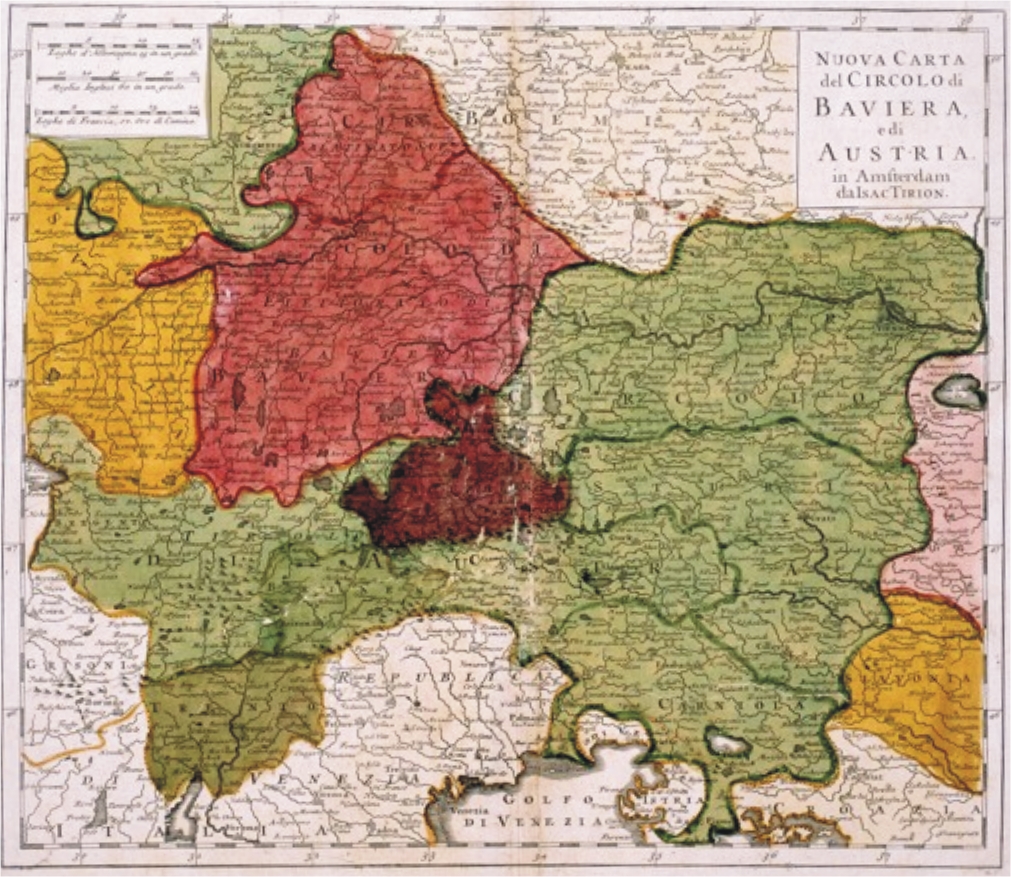
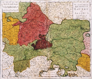
97-Nuova Carta del Circolo di Baviera e di Austria .
This map, drawn in Amsterdam by Isac Tirion, is written in Italian, measures 32,5 x 28 cm and shows with different colours the European regions Svavia Aviera, Austria with Tyrol, Trentino, Carnia and Slavonia in the East. Author: Isac Tirion
Amsterdam,1740 |
|
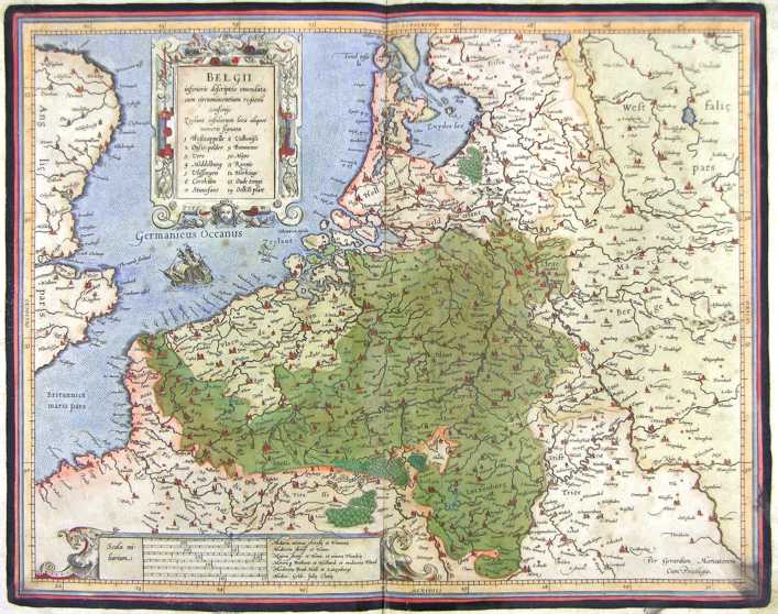
98-Belgii - Belgio .
The map belongs to the Atlas sive Cosmographicae Meditationes de Fabrica Mundi et Fabricati Figura, published in 1644 in Duisburg.
Author: Gerardo Mercatore
Duisburg,1644 |
|
99-Belgio .
The map belongs to the Atlas sive Cosmographicae Meditationes de Fabrica Mundi et Fabricati Figura, published in 1644 in Duisburg. Author: Gerardo Mercatore
Duisburg,1644 |
|
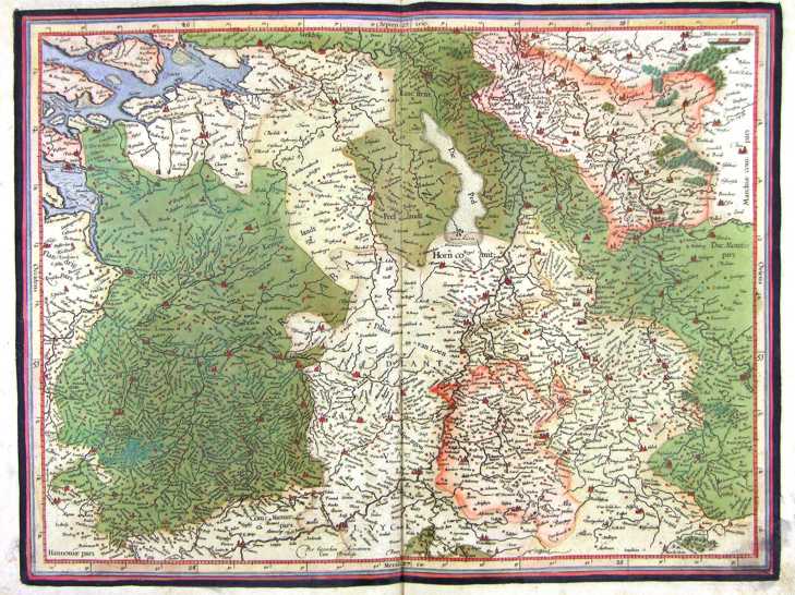
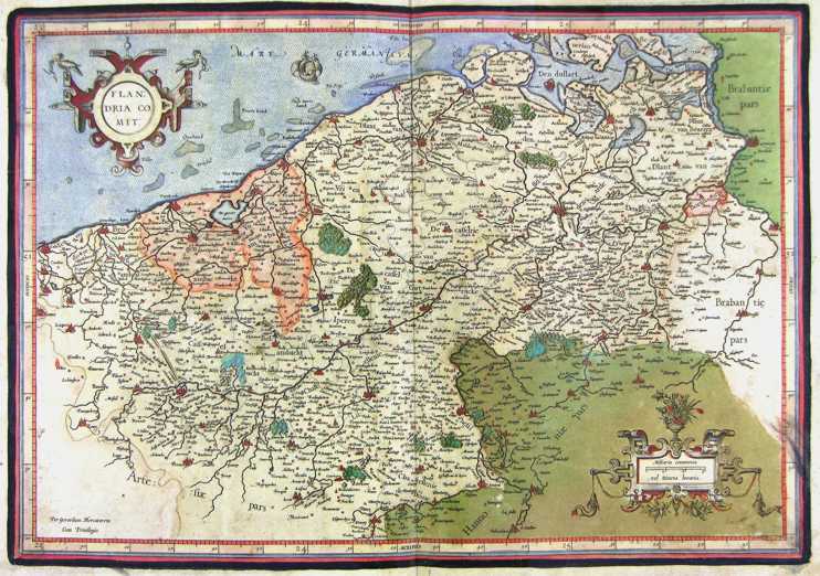
100-Flandria comit - Belgio .
The map belongs to the Atlas sive Cosmographicae Meditationes de Fabrica Mundi et Fabricati Figura, published in 1644 in Duisburg.
Author: Gerardo Mercatore
Duisburg,1644 |

|
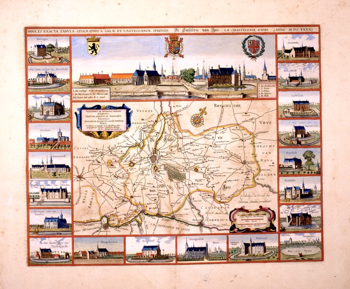
101-Nova et Exacta Tabula Salae et Castellanae Iprensis .
The map created by Antonius Saderus in 1641, measuring 48.4 x 39 cm. At the top you can see the city and 3
coat of arms.
To the inside 2 cartouche and a rose of the winds are found. Map of notable graphic effect. Author: Antonius Saderus
,1641 |
|
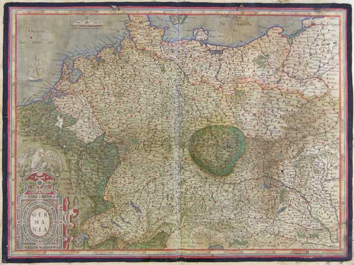
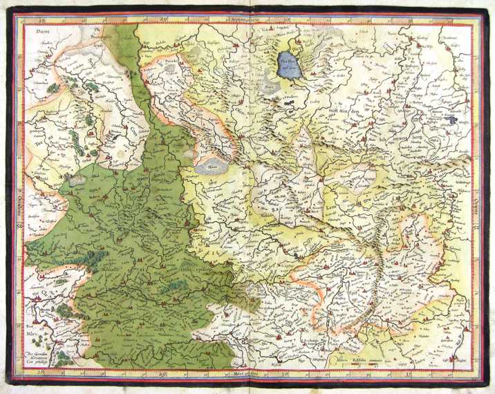
125-Germania .
The map belongs to the Atlas sive Cosmographicae Meditationes de Fabrica Mundi et Fabricati Figura, published in 1611 in Duisburg.
Dimensions 51 x 38 cm. Author: Gerardo Mercatore
Duisburg,1611 |
|
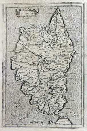
108-Corsica .
The map-drawing measures 22,5 x 38 cm and the whole 27,5 x 44 cm. It can be found on page 280 in the 4th edition of the Atlas sive Cosmographicae Meditationes de Fabrica Mundi et Fabricati Figura, published in 1611 in Duisburg. Author: Gerardo Mercatore
Amsterdam,1611 |
|
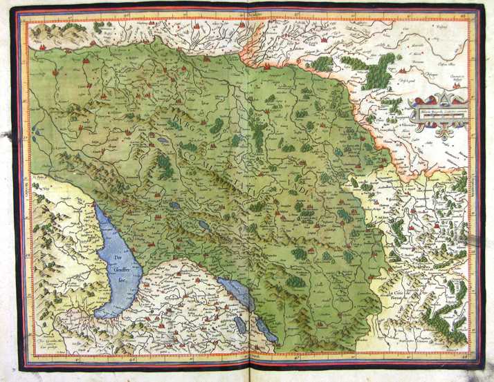
109-Burgundia - Francia .
The map belongs to the Atlas sive Cosmographicae Meditationes de Fabrica Mundi et Fabricati Figura, published in 1611 in Duisburg.
Dimensions: 46,4 x 36,5 cm.
Author: Gerardo Mercatore
Duisburg,1611 |
|
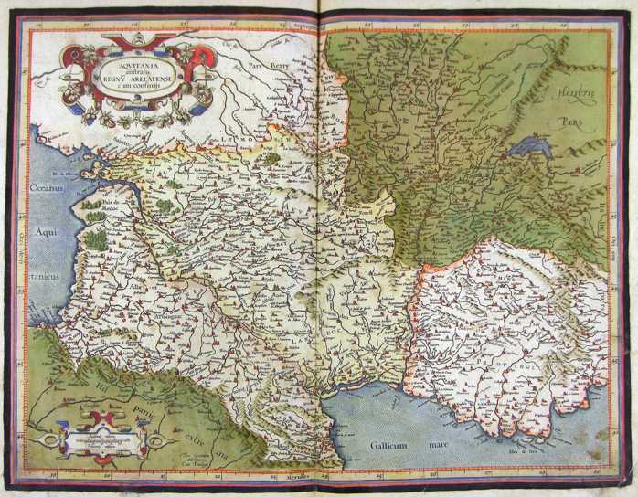
110-Aquitania - Francia .
The map belongs to the Atlas sive Cosmographicae Meditationes de Fabrica Mundi et Fabricati Figura, published in 1611 in Duisburg.
Dimensions: 47,5 x 36,3 cm. Author: Gerardo Mercatore
Duisburg,1611 |
|
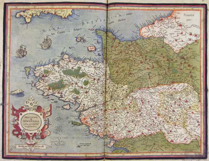
111-Britannia e Normandia - Francia .
The map belongs to the Atlas sive Cosmographicae Meditationes de Fabrica Mundi et Fabricati Figura, published in 1611 in Duisburg.
Dimensions: 47,5 x 36 cm. Author: Gerardo Mercatore
Duisburg,1611 |
|
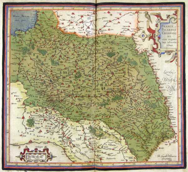
112-Picardie Champagne - Francia .
The map belongs to the Atlas sive Cosmographicae Meditationes de Fabrica Mundi et Fabricati Figura,published in 1611 in Duisburg.
Dimensions: 41 x 37 cm. Author: Gerardo Mercatore
Duisburg,1611 |
|
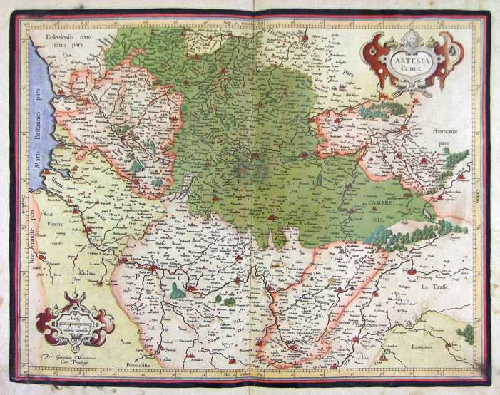
113-Artesia - Francia .
The map belongs to the Atlas sive Cosmographicae Meditationes de Fabrica Mundi et Fabricati Figura, published in 1611 in Duisburg.
Dimensions: 46 x 36 cm.
Author: Gerardo Mercatore
Duisburg,1611 |
|
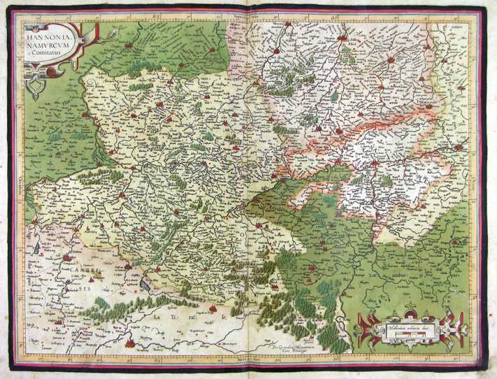
114-Hannonia - Francia .
The map belongs to the Atlas sive Cosmographicae Meditationes de Fabrica Mundi et Fabricati Figura, published in 1611 in Duisburg.
Dimensions: 47,5 x 36,4 cm.
Author: Gerardo Mercatore
Duisburg,1611 |
|
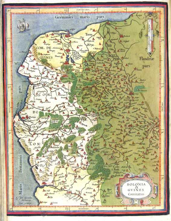
115-Bolonia e Guines - Francia .
The map belongs to the Atlas sive Cosmographicae Meditationes de Fabrica Mundi et Fabricati Figura, published in 1611 in Duisburg.
Dimensions: 33 x 26 cm. Author: Gerardo Mercatore
Duisburg,1611 |
|
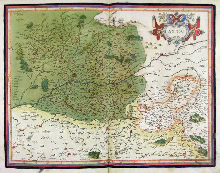
116-Aniou - Francia .
The map belongs to the Atlas sive Cosmographicae Meditationes de Fabrica Mundi et Fabricati Figura, published in 1611 in Duisburg.
Dimensions: 47 x 36,5 cm. Author: Gerardo Mercatore
Duisburg,1611 |
|
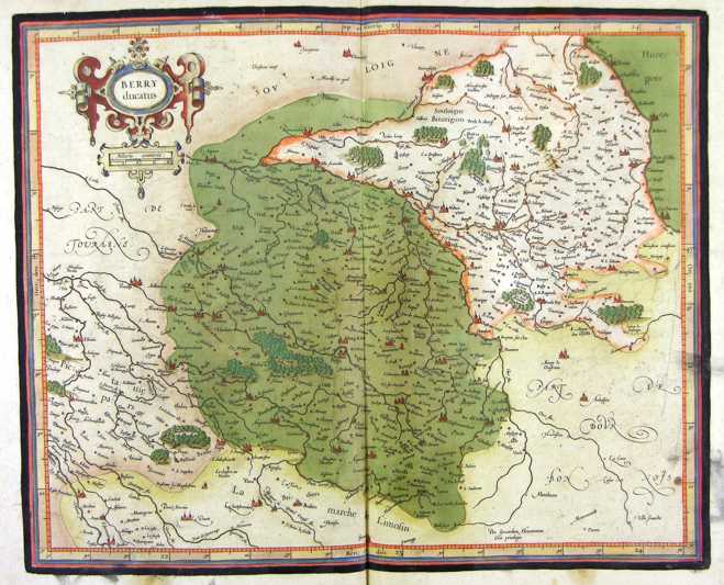
117-Berry - Francia .
The map belongs to the Atlas sive Cosmographicae Meditationes de Fabrica Mundi et Fabricati Figura, published in 1611 in Duisburg.
Dimensions: 42,6 x 36 cm. Author: Gerardo Mercatore
Duisburg ,1611 |
|
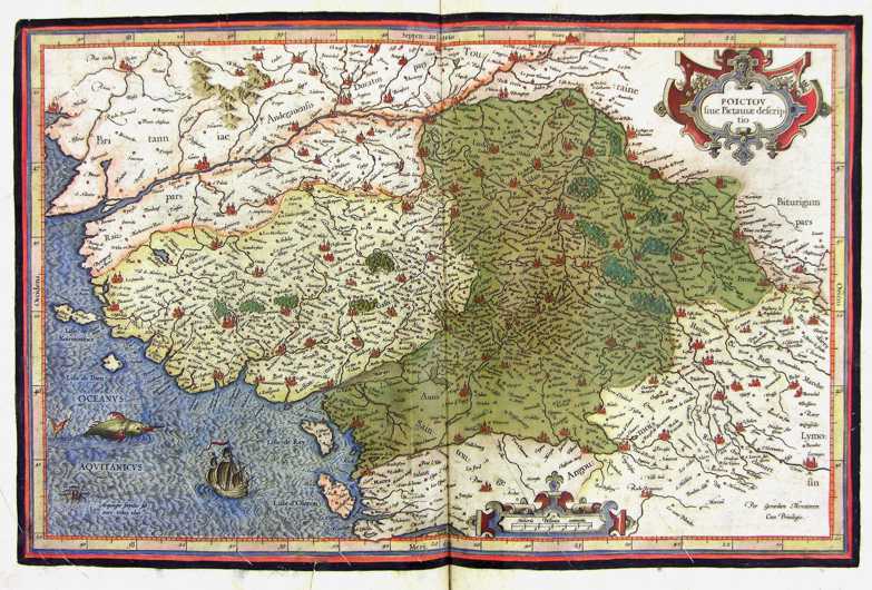
118-Poictou - Francia .
The map belongs to the Atlas sive Cosmographicae Meditationes de Fabrica Mundi et Fabricati Figura, published in 1611 in Duisburg.
Dimensions: 46 x 30 cm. Author: Gerardo Mercatore
Duisburg,1611 |
|
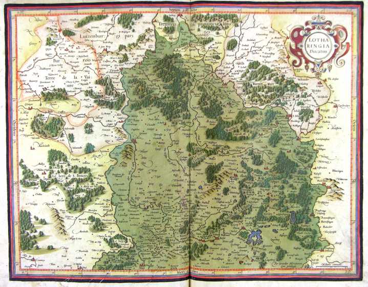
119-Lotharingia - Francia .
The map belongs to the Atlas sive Cosmographicae Meditationes de Fabrica Mundi et Fabricati Figura, published in 1611 in Duisburg.
Dimensions: 47 x 37 cm. Author: Gerardo Mercatore
Duisburg,1611 |
|
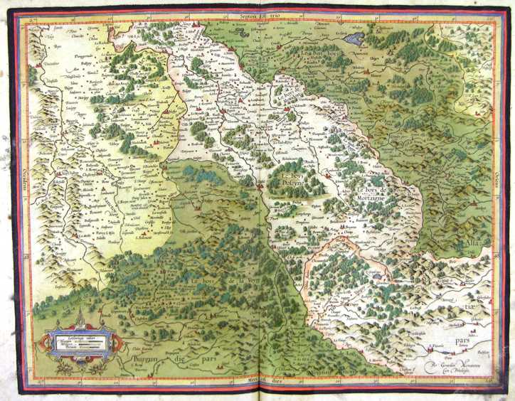
120-Lotharingia - Francia .
The map belongs to the Atlas sive Cosmographicae Meditationes de Fabrica Mundi et Fabricati Figura, published in 1611 in Duisburg.
Dimensions: 46,8 x 37 cm. Author: Gerardo Mercatore
Duisburg,1611 |
|
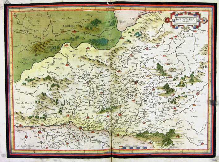
121-Burgundia - Francia .
The map belongs to the Atlas sive Cosmographicae Meditationes de Fabrica Mundi et Fabricati Figura, published in 1611 in Duisburg. Author: Gerardo Mercatore
Duisburg,1611 |
|
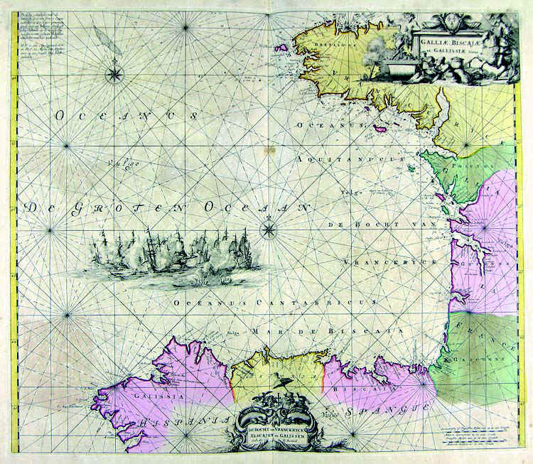
122-Golfo di Biscaglia .
The map belongs to the Atlas de la Navigationet du Commerce qui se fait dans touts le Parties du Monde, published in 1715 in Amsterdam.
Dimensions: 56,6 x 48,5 cm. Author: Louis Renard
Amsterdam,1715 |
|
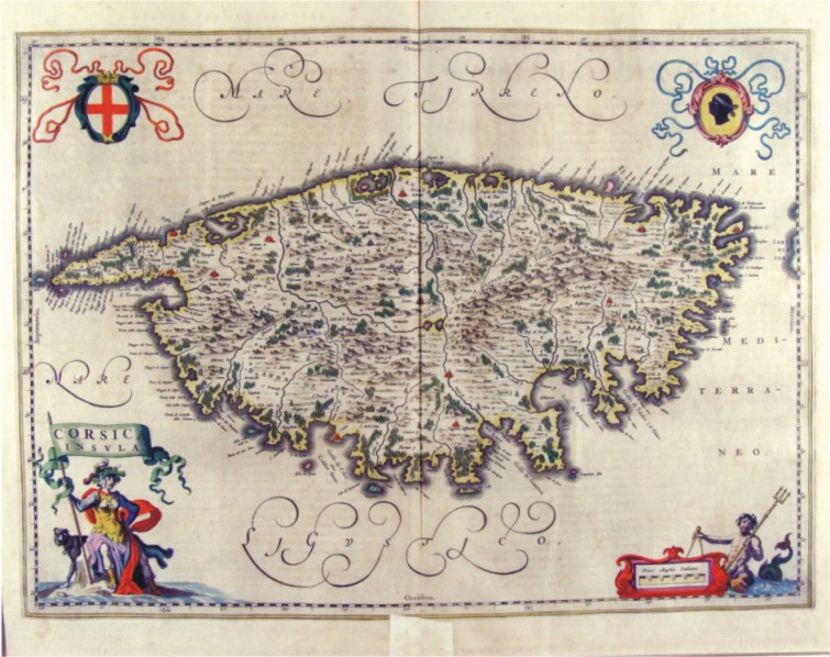
123-Corsica Insula - Francia .
The map belongs to the Atlas Geographiae Blavianae volumen octavum Quo Italia quae est Europae Liber XVI di Blaeu. Published in 1662 in Amsterdam. The map, which is decorated with four cartouches with the Moor at the top right of the flag at the bottom of the scale, the cross at the top right of the republic of Genoa and bottom of a figure with a banner which is contained in the title. The menu offers an island of Corsica full of place names, with the cities represented with red design perspective, many forests and with a good representation of orography and hydrography.
Author: Ioannis Blaeu
Amsterdam,1662 |
|
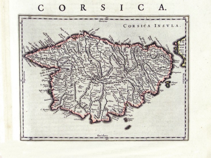
124-Corsica - Francia .
The map measures 24 x 17,8 cm and belongs to the atlas Theatrum Orbis Terrarum sive Atlas Novus - pars tertia - Guilelmus et Ioannis Blaeu, printed in 1650 in the Blaeu's family workshop in Amsterdam. Corsica is exposed in a small scale, but with plenty of citynames. The island also has a schematic representation of the hydrography and the orography. Author: Ioannis Blaeu
Amsterdam,1650 |
|
127-Alsazia sup. - Germania .
The map belongs to the Atlas sive Cosmographicae Meditationes de Fabrica Mundi et Fabricati Figura, published in 1611 in Duisburg.
Author: Gerardo Mercatore
Duisburg,1611 |
|
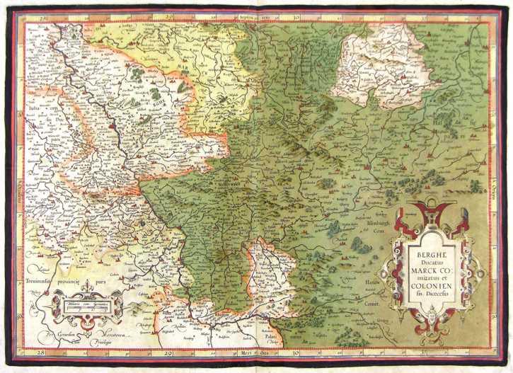
128-Berghe, Colonien - Germania .
The map belongs to the Atlas sive Cosmographicae Meditationes de Fabrica Mundi et Fabricati Figura, published in 1611 in Duisburg.
Author: Gerardo Mercatore
Duisburg,1611 |
|
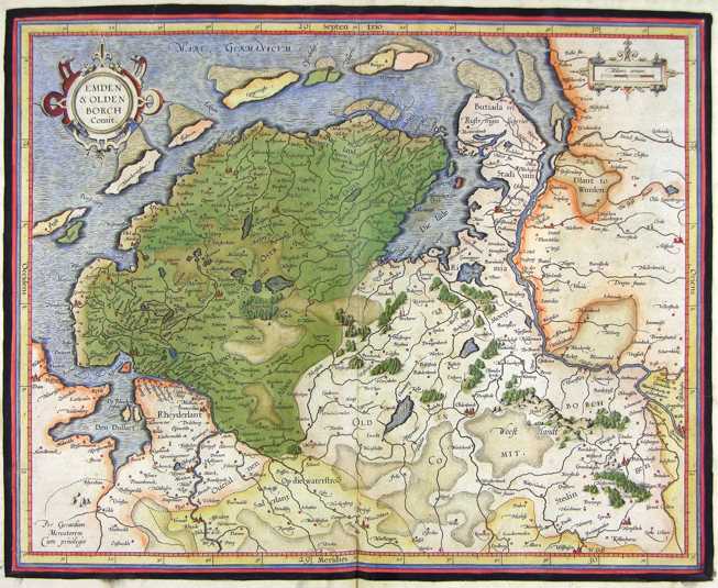
129-Emden e Olden - Germania .
The map belongs to the Atlas sive Cosmographicae Meditationes de Fabrica Mundi et Fabricati Figura, published in 1611 in Duisburg.
Author: Gerardo Mercatore
Duisburg,1611 |
|
130-Bavaria - Germania .
The map belongs to the Atlas sive Cosmographicae Meditationes de Fabrica Mundi et Fabricati Figura, published in 1611 in Duisburg. Author: Mercatore
Duisburg,1611 |
|
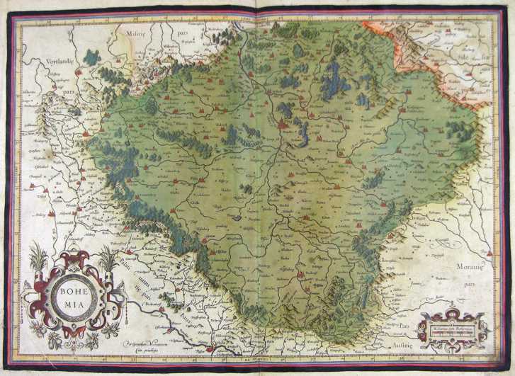
131-Boemia - Germania .
The map belongs to the Atlas sive Cosmographicae Meditationes de Fabrica Mundi et Fabricati Figura, published in 1611 in Duisburg.
Author: Gerardo Mercatore
Duisburg,1611 |
|
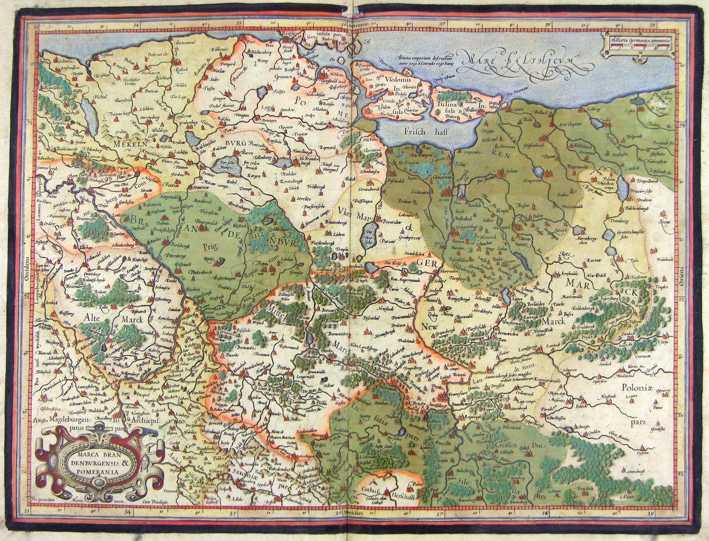
132-Marca Brandeburghensis e Pomerania - Germania .
The map belongs to the Atlas sive Cosmographicae Meditationes de Fabrica Mundi et Fabricati Figura,published in 1611 in Duisburg.
Author: Gerardo Mercatore
Duisburg,1611 |
|
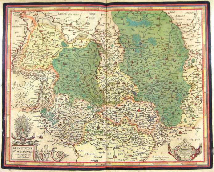
133-Braunswych e Mexdburg - Germania .
The map belongs to the Atlas sive Cosmographicae Meditationes de Fabrica Mundi et Fabricati Figura, published in 1611 in Duisburg.
Author: Gerardo Mercatore
Duisburg,1611 |
|
134-Frisia - Germania .
The map belongs to the Atlas sive Cosmographicae Meditationes de Fabrica Mundi et Fabricati Figura, published in 1611 in Duisburg.
Author: Gerardo Mercatore
Duisburg,1611 |
|
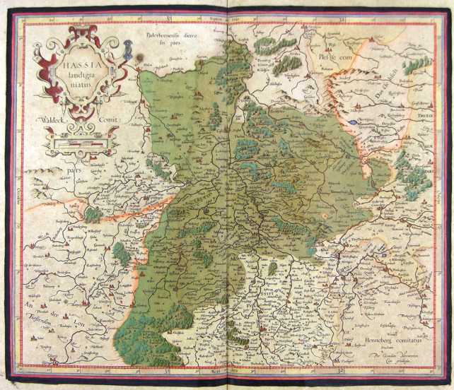
135-Hassia - Germania .
The map belongs to the Atlas sive Cosmographicae Meditationes de Fabrica Mundi et Fabricati Figura, published in 1611 in Duisburg.
Author: Gerardo Mercatore
Duisburg,1611 |
|
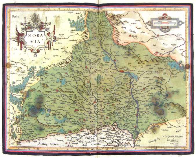
136-Moravia - Germania .
The map belongs to the Atlas sive Cosmographicae Meditationes de Fabrica Mundi et Fabricati Figura, published in 1611 in Duisburg.
Author: Gerardo Mercatore
Duisburg,1611 |
|
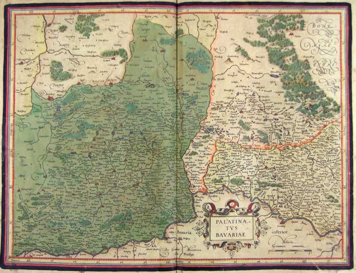
137-Palatinatus Bavaria - Germania .
The map belongs to the Atlas sive Cosmographicae Meditationes de Fabrica Mundi et Fabricati Figura, published in 1611 in Duisburg.
Author: Gerardo Mercatore
Duisburg,1611 |
|
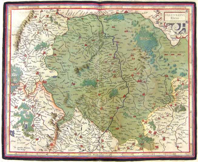
138-Palatinatus Reno - Germania .
The map belongs to the Atlas sive Cosmographicae Meditationes de Fabrica Mundi et Fabricati Figura, published in 1611 in Duisburg.
Author: Gerdardo Mercatore
Duisburg,1611 |
|
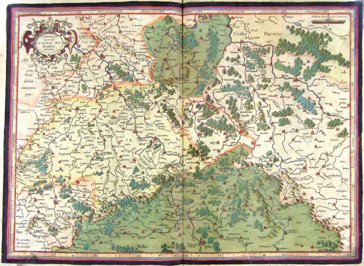
139-Sassonia e Lusatiae - Germania .
The map belongs to the Atlas sive Cosmographicae Meditationes de Fabrica Mundi et Fabricati Figura, published in 1611 in Duisburg.
Author: Gerardo Mercatore
Duisburg,1611 |
|
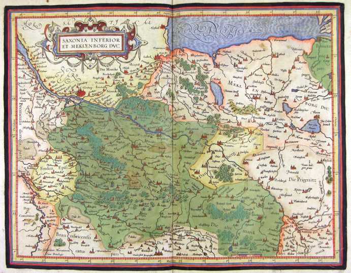
140-Sassonia inf. e Meklenbor - Germania .
The map belongs to the Atlas sive Cosmographicae Meditationes de Fabrica Mundi et Fabricati Figura, published in 1611 in Duisburg.
Author: Gerardo Mercatore
Duisburg,1611 |
|
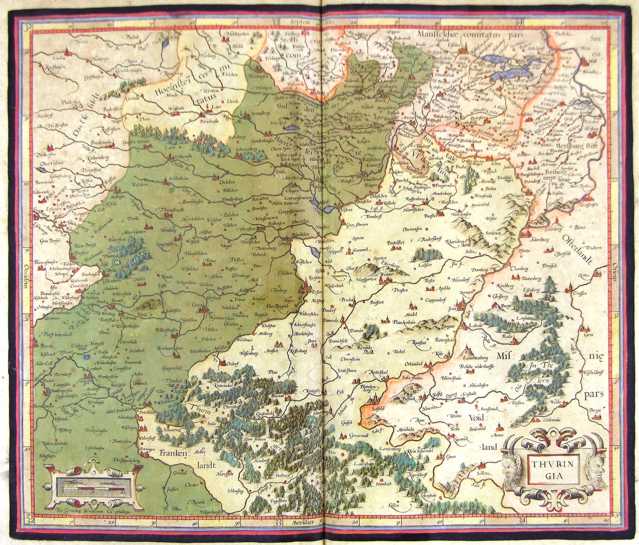
141-Turingia - Germania .
The map belongs to the Atlas sive Cosmographicae Meditationes de Fabrica Mundi et Fabricati Figura, published in 1611 in Duisburg.
Author: Gerardo Mercatore
Duisburg,1611 |
|
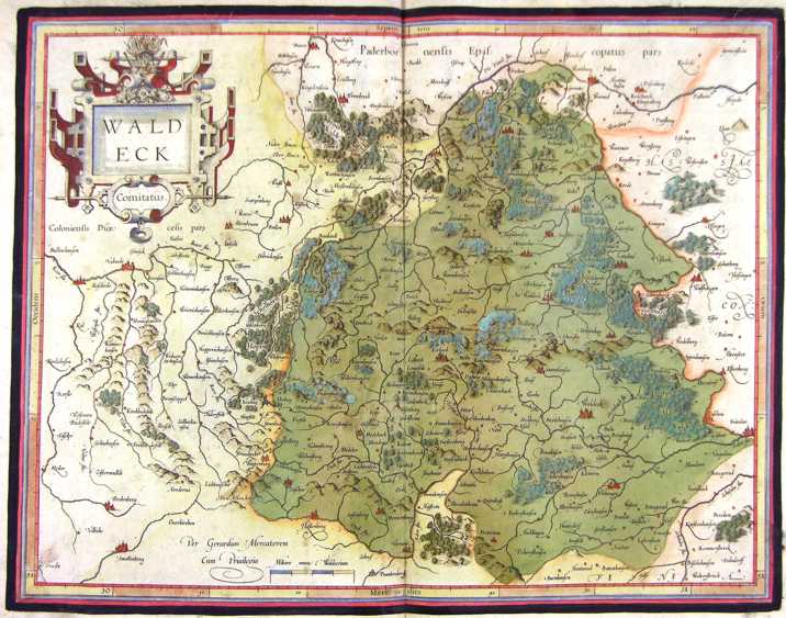
142-Waldeck - Germania .
The map belongs to the Atlas sive Cosmographicae Meditationes de Fabrica Mundi et Fabricati Figura, published in 1611 in Duisburg.
Author: Gerardo Mercatore
Duisburg,1611 |
|
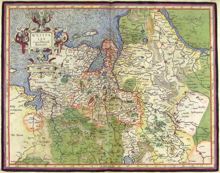
143-Westfalia - Germania .
The map belongs to the Atlas sive Cosmographicae Meditationes de Fabrica Mundi et Fabricati Figura, published in 1611 in Duisburg.
Author: Gerardo Mercatore
Duisburg,1611 |
|
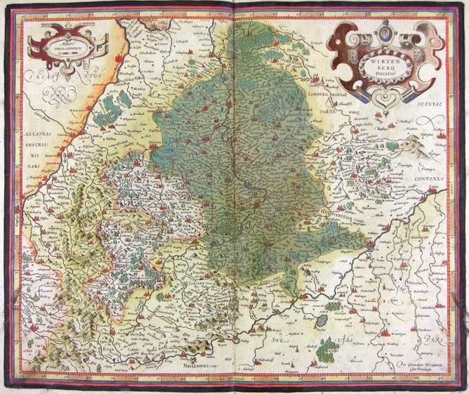
144-Wirtenberg - Germania .
The map belongs to the Atlas sive Cosmographicae Meditationes de Fabrica Mundi et Fabricati Figura, published in 1611 in Duisburg.
Author: Gerardo Mercatore
Duisburg,1611 |
|
145-Germania .
The map belongs to the Atlas sive Cosmographicae Meditationes de Fabrica Mundi et Fabricati Figura, published in 1611 in Duisburg.
Author: Gerardo Mercatore
Duisburg,1611 |
|
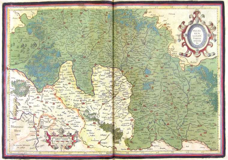
146-Francia Orientalis - Germania .
The map belongs to the Atlas sive Cosmographicae Meditationes de Fabrica Mundi et Fabricati Figura, published in 1611 in Duisburg.
Author: Gerardo Mercatore
Duisburg,1611 |
|
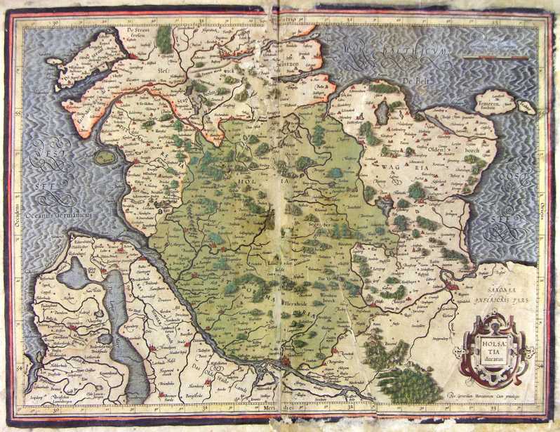
147-Holsazia - Germania .
The map belongs to the Atlas sive Cosmographicae Meditationes de Fabrica Mundi et Fabricati Figura, published in 1611 in Duisburg.
Author: Gerardo Mercatore
Duisburg,1611 |
|
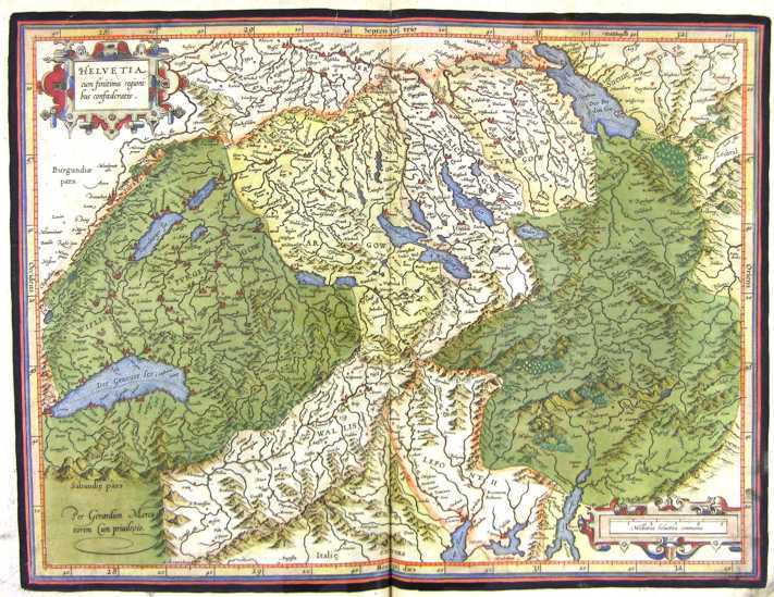
148-Helvetia - Svizzera .
The map belongs to the Atlas sive Cosmographicae Meditationes de Fabrica Mundi et Fabricati Figura, published in 1644 in Duisburg. Author: Gerardo Mercatore
Duisburg,1644 |
|
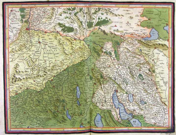
149-Helvetia - Svizzera settentrionale .
The map belongs to the Atlas sive Cosmographicae Meditationes de Fabrica Mundi et Fabricati Figura, published in 1644 in Duisburg.
Author: Gerardo Mercatore
Duisburg,1644 |
|
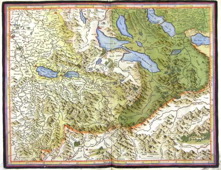
150-Helvetia - Svizzera centrale .
The map belongs to the Atlas sive Cosmographicae Meditationes de Fabrica Mundi et Fabricati Figura, published in 1644 in Duisburg.
Author: Gerardo Mercatore
Duisburg,1644 |
|
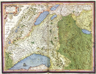
151-Wiflispur - Svizzera occidentale .
The map belongs to the Atlas sive Cosmographicae Meditationes de Fabrica Mundi et Fabricati Figura, published in 1644 in Duisburg.
Author: Gerardo Mercatore
Duisburg,1644 |
|
152-Stato della Chiesa .
The Map of the Dukedom of Toscany and the Church States, from Romagna to Latium, showing a picture of sacred images surrounding the title and a metric scale residing in a boundary stone with two babies holding the Papal flag.This map measures 49,2 x 38 cm and is taken from the atlas Theatrum Orbis Terrarum sive Atlas Novus - pars tertia - Guilelmus et Ioannis Blaeu, printed in 1650 in the Blaeu family workshop in Amsterdam.. Author: Ioannis Blaeu
Amsterdam,1650 |
|
153-Stato della Chiesa .
The Map belongs to the atlas Geographiae Blavianae volumen octavum Quo Italia quae est Europae Liber XVI di Blaeu, printed in 1592 in Amsterdam. Author: Ioannis Blaeu
Amsterdam,1662 |
|
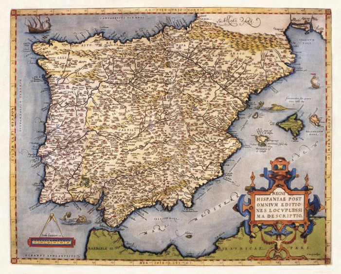
154-Iberian Peninsula .
The Map belongs to the atlas Theatrum Orbis Terrarum, printed in 1592 in Antwerp. Author: Abramus Ortelius
Anversa,1592 |
|
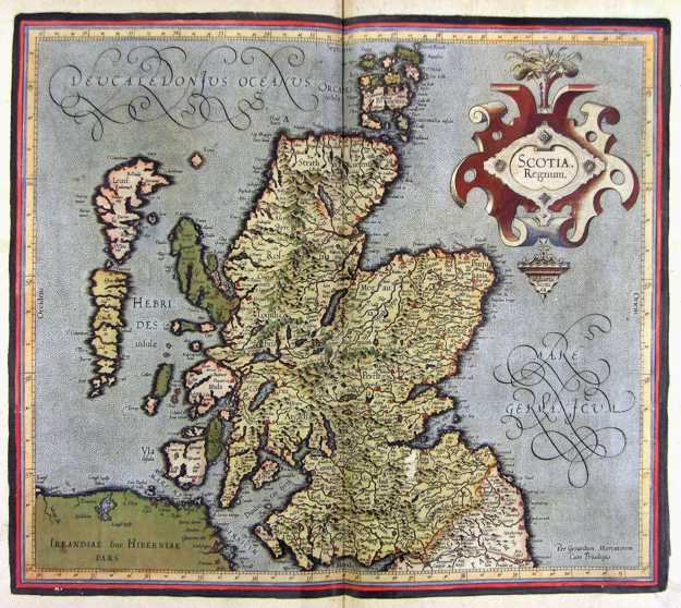
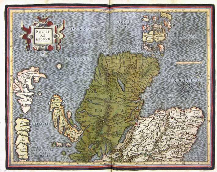
155-Scotiae Regnum - Scozia .
The map belongs to the Atlas sive Cosmographicae Meditationes de Fabrica Mundi et Fabricati Figura, published in 1644 in Duisburg.
Author: Gerardo Mercatore
Duisburg,1644 |
|
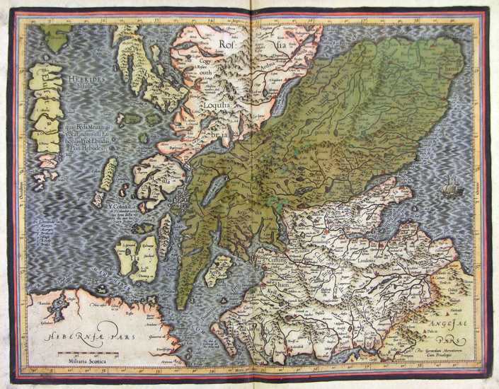
156-Scotiae Regnum - Nord - Scozia .
The map belongs to the Atlas sive Cosmographicae Meditationes de Fabrica Mundi et Fabricati Figura, published in 1611 in Duisburg.
Author: Gerardo Mercatore
Duisburg,1644 |
|
157-Scotiae Regnum - Sud - Scozia .
The map belongs to the Atlas sive Cosmographicae Meditationes de Fabrica Mundi et Fabricati Figura, published in 1644 in Duisburg. Author: Gerardo Mercatore
Duisburg,1644 |
|
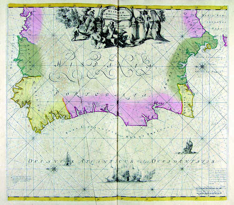
158-Hispaniae et Portugalliae - Portogallo e Spagna .
The map belongs to the Atlas de la Navigationet du Commerce qui se fait dans touts le Parties du Monde, published in 1715 in Amsterdam. Author: Louis Renard
Amsterdam,1715 |
|
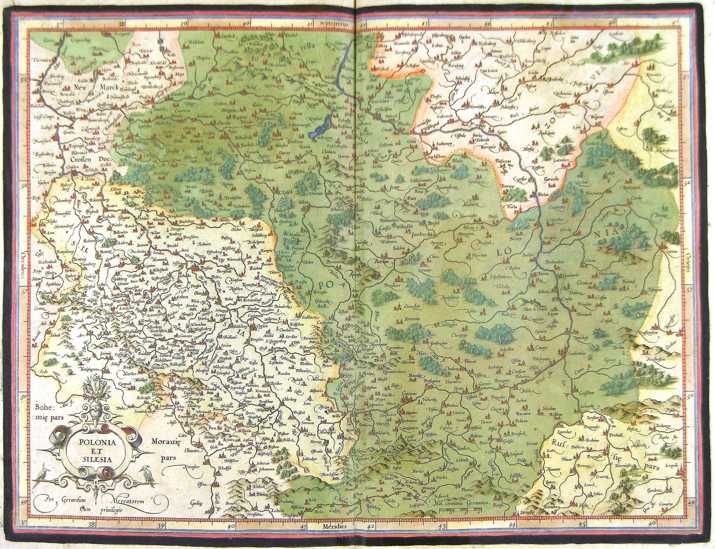
159-Polonia et Silesia - Polonia .
The map belongs to the Atlas sive Cosmographicae Meditationes de Fabrica Mundi et Fabricati Figura, published in 1644 in Duisburg.
Author: Gerardo Mercatore
Duisburg,1644 |
|
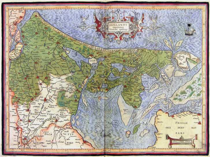
160-Hollandt - Olanda .
The map belongs to the Atlas sive Cosmographicae Meditationes de Fabrica Mundi et Fabricati Figura, published in 1644 in Duisburg. Author: Gerardo Mercatore
Duisburg,1644 |
|
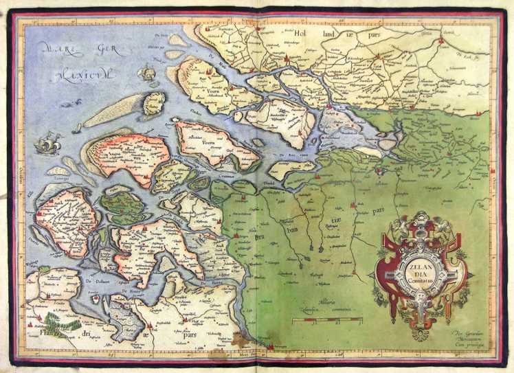
161-Zelandia - Olanda .
The map belongs to the Atlas sive Cosmographicae Meditationes de Fabrica Mundi et Fabricati Figura, published in 1644 in Duisburg. Author: Gerardo Mercatore
Duisburg,1644 |
|
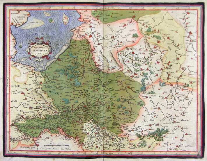
162-Geldria et Transysulana - Olanda .
The map belongs to the Atlas sive Cosmographicae Meditationes de Fabrica Mundi et Fabricati Figura, published in 1644 in Duisburg.
Author: Gerardo Mercatore
Duisburg,1644 |
|
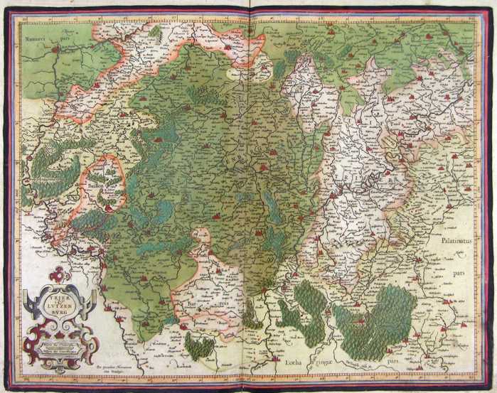
163-Trier et Lutzemburg - Lussemburgo .
The map belongs to the Atlas sive Cosmographicae Meditationes de Fabrica Mundi et Fabricati Figura, published in 1644 in Duisburg. Author: Gerardo Mercatore
Duisburg,1644 |
|
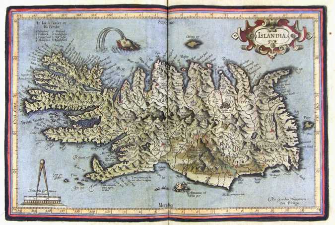
164-Islandia - Islanda .
The map belongs to the Atlas sive Cosmographicae Meditationes de Fabrica Mundi et Fabricati Figura, published in 1644 in Duisburg. Author: Gerardo Mercatore
Duisburg,1644 |
|
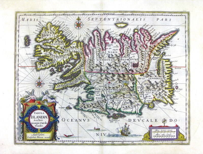
165-Tabula Islandiae - Islanda .
The map belongs to the Atlas sive Cosmographicae Meditationes de Fabrica Mundi et Fabricati Figura, published in 1644 in Duisburg.
Author: Ioannis Blaeu
Amsterdam,1665 |
|
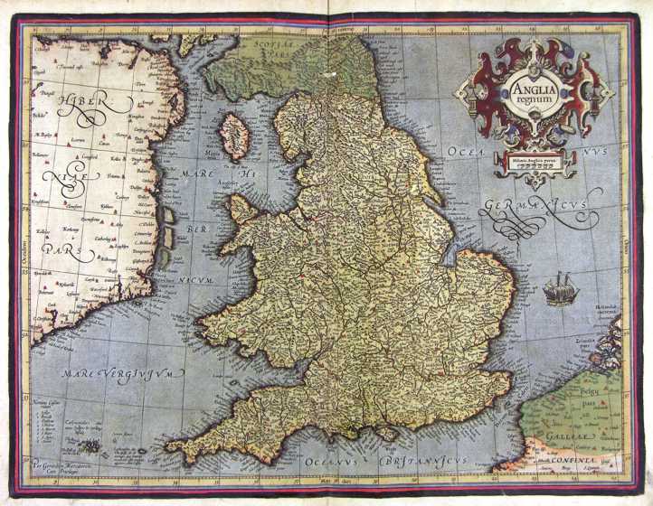
166-Anglia Regnum - Gran Bretagna .
The map belongs to the Atlas sive Cosmographicae Meditationes de Fabrica Mundi et Fabricati Figura, published in 1644 in Duisburg.
Author: Gerardo Mercatore
Duisburg,1644 |
|
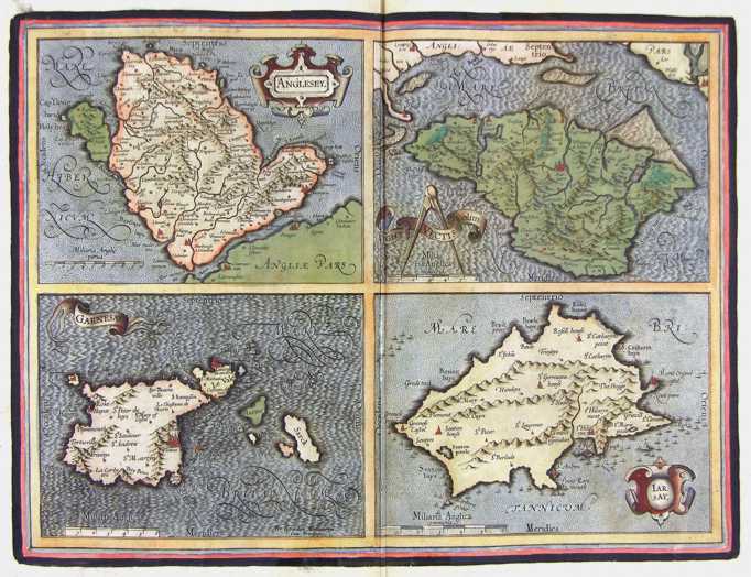
167- Isole Inglesi - Gran Bretagna .
The map belongs to the Atlas sive Cosmographicae Meditationes de Fabrica Mundi et Fabricati Figura, published in 1644 in Duisburg.
Author: Gerardo Mercatore
Duisburg,1644 |
|
168-Gran Bretagna Sud Orientale .
The map belongs to the Atlas sive Cosmographicae Meditationes de Fabrica Mundi et Fabricati Figura, published in 1644 in Duisburg.
Author: Gerardo Mercatore
Duisburg,1644 |
|
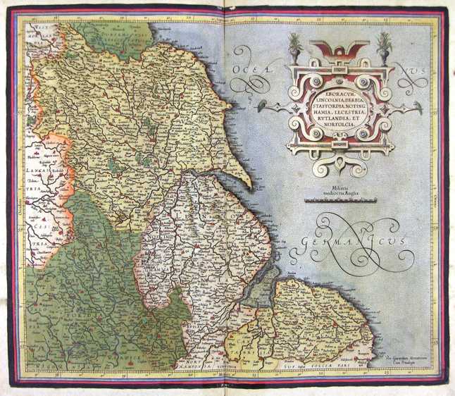
169-Gran Bretagna Centro Orientale .
The map belongs to the Atlas sive Cosmographicae Meditationes de Fabrica Mundi et Fabricati Figura, published in 1644 in Duisburg.
Author: Gerardo Mercatore
Duisburg,1644 |
|
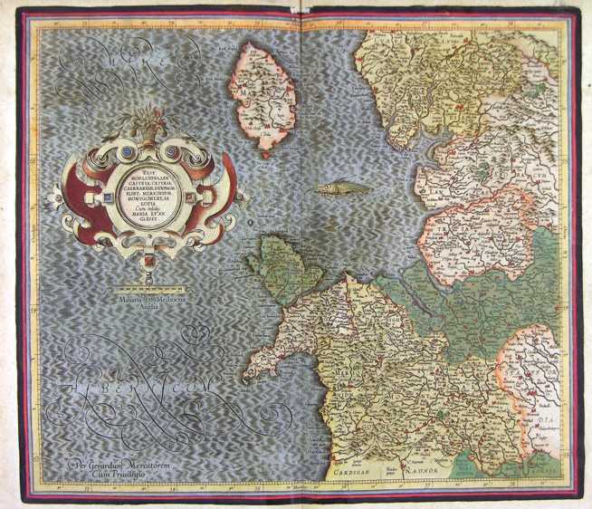
170-Gran Bretagna Centro Occidentale .
The map belongs to the Atlas sive Cosmographicae Meditationes de Fabrica Mundi et Fabricati Figura, published in 1644 in Duisburg.
Author: Gerardo Mercatore
Duisburg,1644 |
|
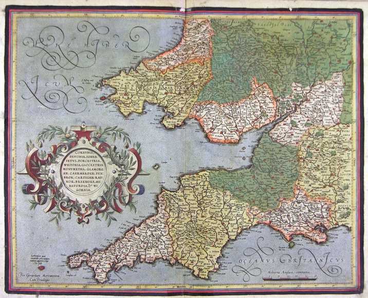
171-Gran Bretagna Sud Occidentale .
The map belongs to the Atlas sive Cosmographicae Meditationes de Fabrica Mundi et Fabricati Figura, published in 1644 in Duisburg.
Author: Gerardo Mercatore
Duisburg,1644 |
|
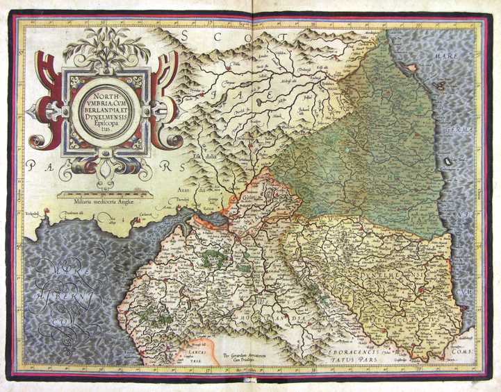
172-North Umbria - Gran Bretagna .
The map belongs to the Atlas sive Cosmographicae Meditationes de Fabrica Mundi et Fabricati Figura, published in 1644 in Duisburg.
Author: Gerardo Mercatore
Duisburg,1644 |
|
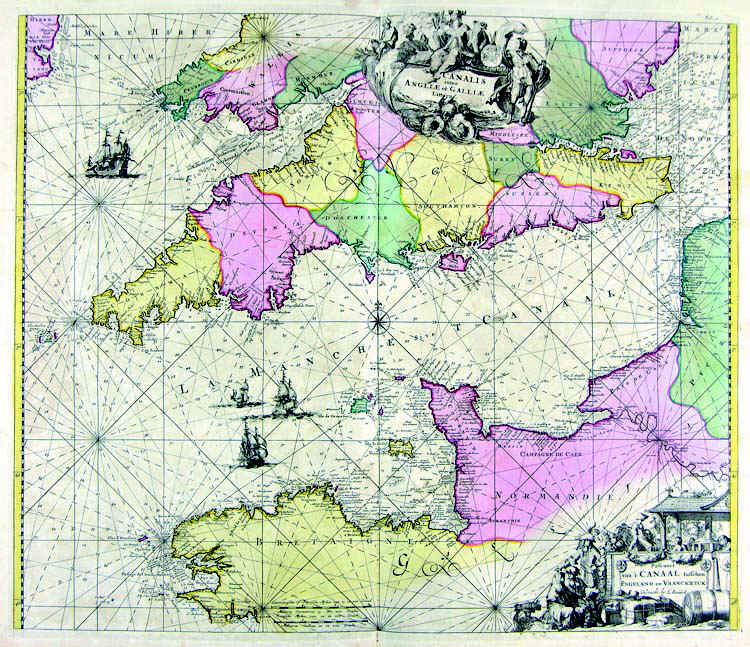
173-Stretto della Manica .
The map belongs to the Atlas de la Navigationet du Commerce qui se fait dans touts le Parties du Monde, published in 1715 in Amsterdam. Author: Louis Renard
Amsterdam,1715 |
|
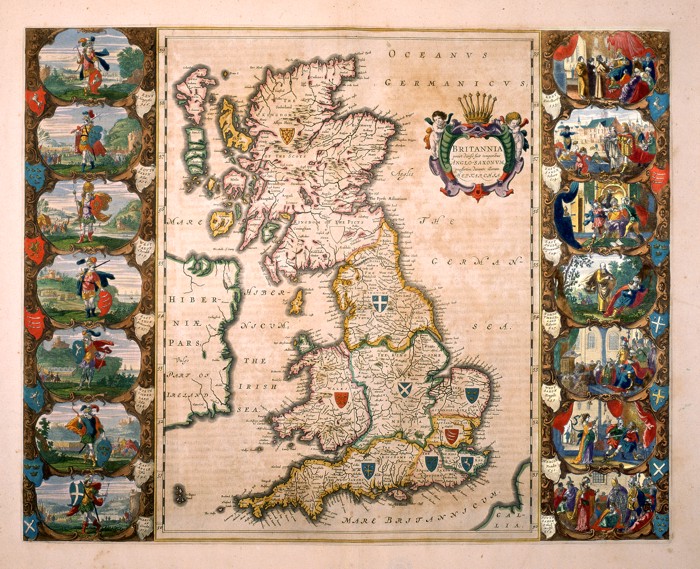
174-Bitannia .
Great Britain and a part of Ireland. This map of the 16thcentury measures 56 x 41 cm and distinguishes the island in seven regions, each of them with a blazon. There are fourteen historical scenes on the sides. The title picture on the right shows the inscription Prout divisa fuit temporibus Anglo-Saxonum praesertim durante illorum Heptarchia. Author: Willem and Ioannis Blaeu
Amsterdam,0 |
|
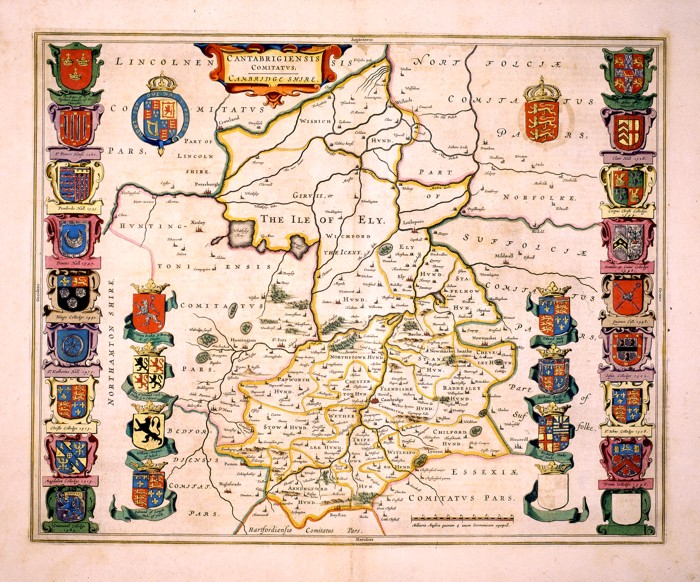
175-Cantabrigiensis Comitatus. Cambridge Shire .
The region of Cambridge in England. An important historical and geographical map, showing the precise borders of different regions, 28 blazons, a decorative title picture on the top right and a graphic scale at the bottom. This map of the 17th century measures 41,6 x 52cm. Author: Ioannis Blaeu
Amsterdam,0 |
|
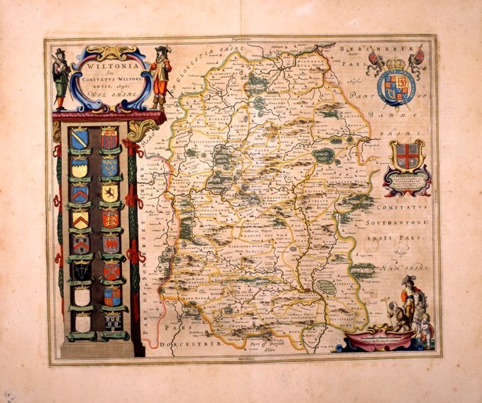
176-Wiltonia. Sive comitatus wiltoniensis; anglis wil shire .
This map of the 17 thcentury, measures 49,5 x 41 and shows a beautiful title picture standing over a column of sixteen blazons on the left and two decorative pictures and a graphic scale with scenes of that epoch on the right. The water courses are precisely drawn, however the hills are approximatively distributed all over the whole region. Author: Ioannis Blaeu
Amsterdam,0 |
|
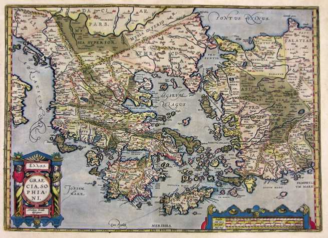
177-Graeciae Sophiani .
The map measures 33 x 49,2 cm and can be found in the atlas Theatrum Orbis Terrarum, edition released in 1589. This very beautiful and colored map represents the South Balkans and the West Turkey. Author: Abramo Ortelio
Anversa,1589 |
|
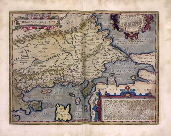
178-Traciae Veteris .
The well colored map measures 35 x 46,5 cm and can be found in the atlas Theatrum Orbis Terrarum, edition released in 1589. Author: Abramo Ortelio
Anversa,1589 |
|
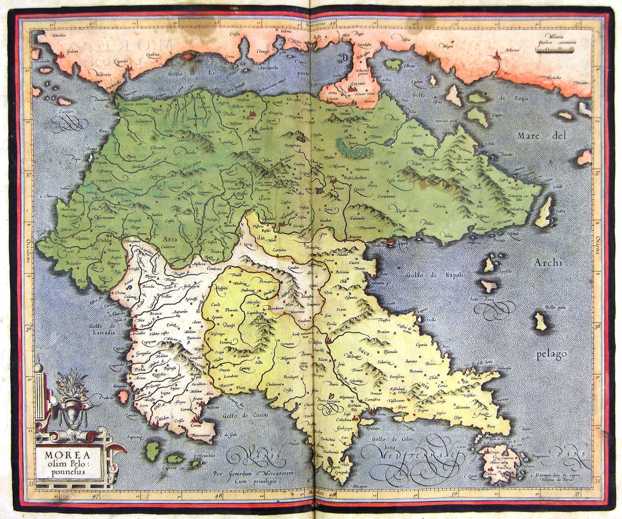
179-Morea - Grecia .
The map belongs to the Atlas sive Cosmographicae Meditationes de Fabrica Mundi et Fabricati Figura, published in 1611 in Duisburg.
Author: Gerardo Mercatore
Duisburg,1611 |
|
180-Isole Greche .
The map belongs to the Atlas sive Cosmographicae Meditationes de Fabrica Mundi et Fabricati Figura, published in 1611 in Duisburg.
Author: Gerardo Mercatore
Duisburg,1611 |
|
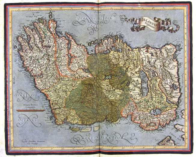
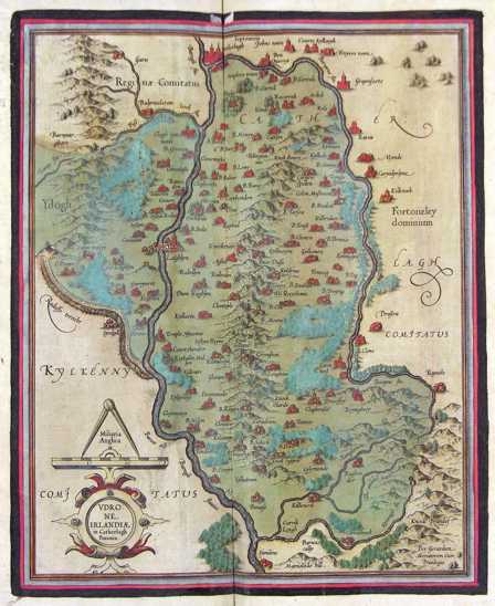
183-Irlandia Regnum - Irlanda .
The map belongs to the Atlas sive Cosmographicae Meditationes de Fabrica Mundi et Fabricati Figura, published in 1644 in Duisburg.
Author: Gerardo Mercatore
Duisburg,1644 |
|
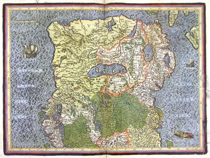
184-Irlandia Regnum - Nord - Irlanda .
The map belongs to the Atlas sive Cosmographicae Meditationes de Fabrica Mundi et Fabricati Figura, published in 1644 in Duisburg.
Author: Gerardo Mercatore
Duisburg,1644 |
|
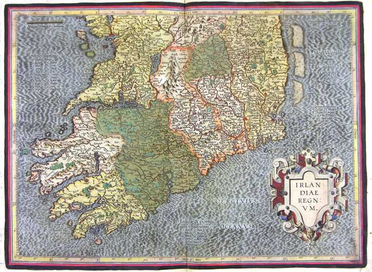
185-Irlandia Regnum - Sud - Irlanda .
The map belongs to the Atlas sive Cosmographicae Meditationes de Fabrica Mundi et Fabricati Figura, published in 1644 in Duisburg.
Author: Gerardo Mercatore
Duisburg,1644 |
|
186-Udrone - Irlanda .
The map belongs to the Atlas sive Cosmographicae Meditationes de Fabrica Mundi et Fabricati Figura, published in 1644 in Duisburg.
Author: Gerardo Mercatore
Duisburg,1644 |
|
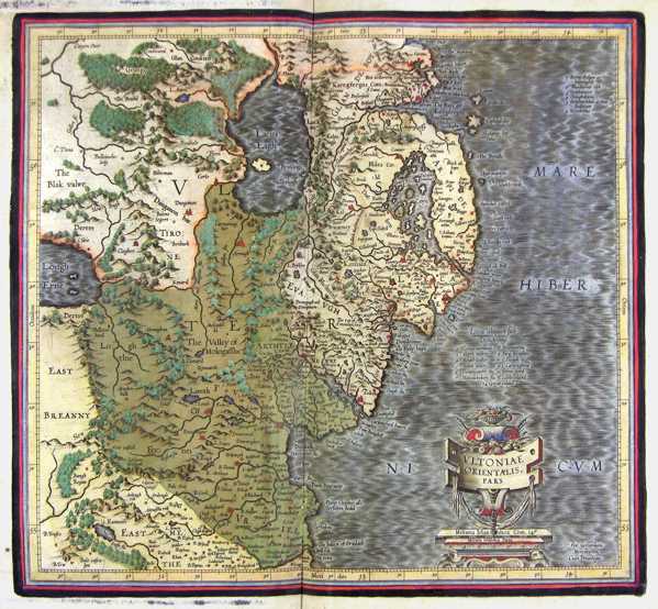
187-Ultoniae Orientalis - Irlanda .
The map belongs to the Atlas sive Cosmographicae Meditationes de Fabrica Mundi et Fabricati Figura, published in 1644 in Duisburg.
Author: Gerardo Mercatore
Duisburg,1644 |

|
205-Austria .
The map belongs to the Atlas sive Cosmographicae Meditationes de Fabrica Mundi et Fabricati Figura, published in 1644 in Duisburg.
Author: Gerardo Mercatore
Duisburg,1644 |
|
209-Salisburgo - Austria .
The map belongs to the Atlas sive Cosmographicae Meditationes de Fabrica Mundi et Fabricati Figura, published in 1644 in Duisburg.
Author: Gerardo Mercatore
Duisburg,1644 |
|
210-Stiria - Austria .
The map belongs to the Atlas sive Cosmographicae Meditationes de Fabrica Mundi et Fabricati Figura, published in 1644 in Duisburg.
Author: Gerardo Mercatore
Duisburg,1644 |
|
211-Nuova Carta del Circolo di Baviera e di Austria .
The Map, realized in Amsterdam by Isac Tirion, it is in Italian language, measure in the sketch cm 32,5x28 and it represents, with different colors, the various regions of that part of Europe understood among Swabia aviera, Austria, with under the Tirol, the Trentino and, to East, Carnia and Slavonia.
Author: Isac Tirion
Amsterdam,0 |

|
212-Belgii - Belgio .
The map belongs to the Atlas sive Cosmographicae Meditationes de Fabrica Mundi et Fabricati Figura, published in 1644 in Duisburg. Author: Gerardo Mercatore
Duisburg,1644 |

|
213-Belgio .
The map belongs to the Atlas sive Cosmographicae Meditationes de Fabrica Mundi et Fabricati Figura, published in 1644 in Duisburg. Author: Gerardo Mercatore
Duisburg,1644 |

|
214-Flandria comit - Belgio .
The map belongs to the Atlas sive Cosmographicae Meditationes de Fabrica Mundi et Fabricati Figura, published in 1644 in Duisburg.
Author: Gerardo Mercatore
Duisburg,1644 |
|
215-Nova et Exacta Tabula Salae et Castellanae Iprensis .
The region of Ypres in Belgium with its twenty castles, a view of the city and three blazons at the top. This detailed map shows two decorative pictures and a wind rose. Drawn by Antonius Saderus, it measures 48,4 x 39 cm. Author: Antonius Sanderus
Amsterdam,1641 |
|
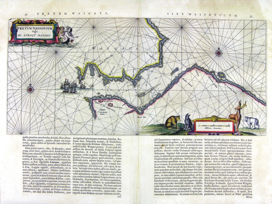
424-Fretum Nassovium .
Author: Ioannis Blaeu
Amsterdam,1660 |
|
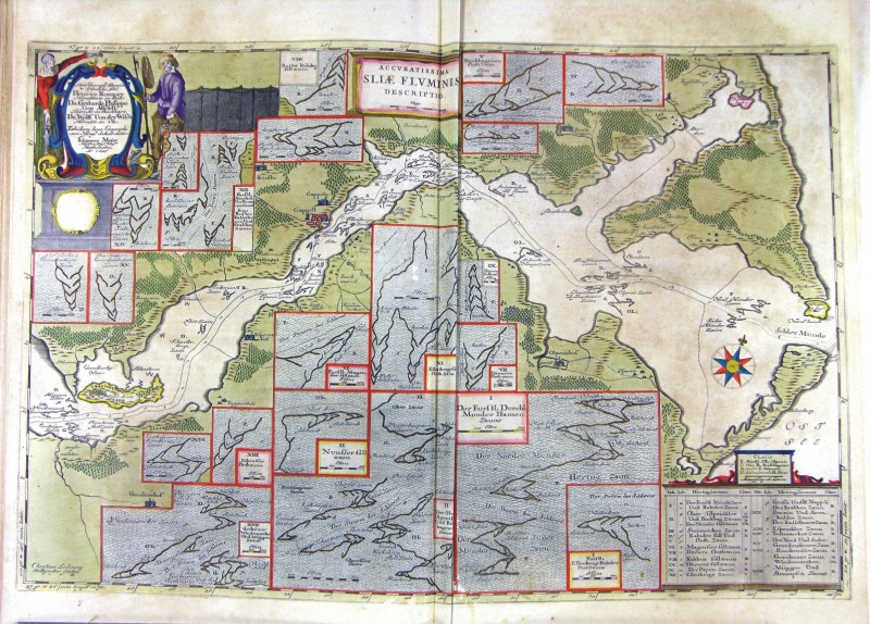
425-Sliae Fluminis .
Author: Ioannis Blaeu
Amsterdam,1674 |
|
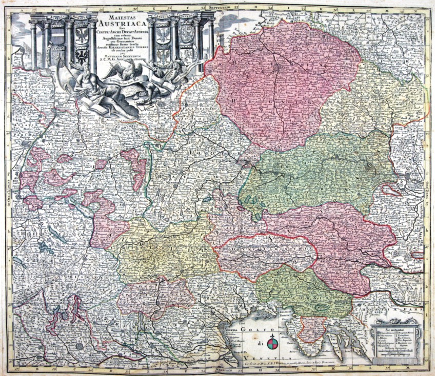
459-AUSTRIACA .
The map (cm 52,5 x 70,0), which is contained in the collection of cards Matthäus Seutter entitled Sphaerae artificiales of 1730, was printed in Augsburg in the publishing house of Jeremias Wolff. Cartouche in the upper right corner shows the title Italia secundum observationes Societatis Regiae Scientiarum quae est Parisiis nec non R.P.Riccioli Societatis Iesu aliorumque Astronomorum et diversorum Memorialium concinnata Per G. De L’Isle Geog.Parisiensem prostat nunc in Officina Ierem.Wolfii. Author: Matthäus Seutter
Augusta,1730 |
|
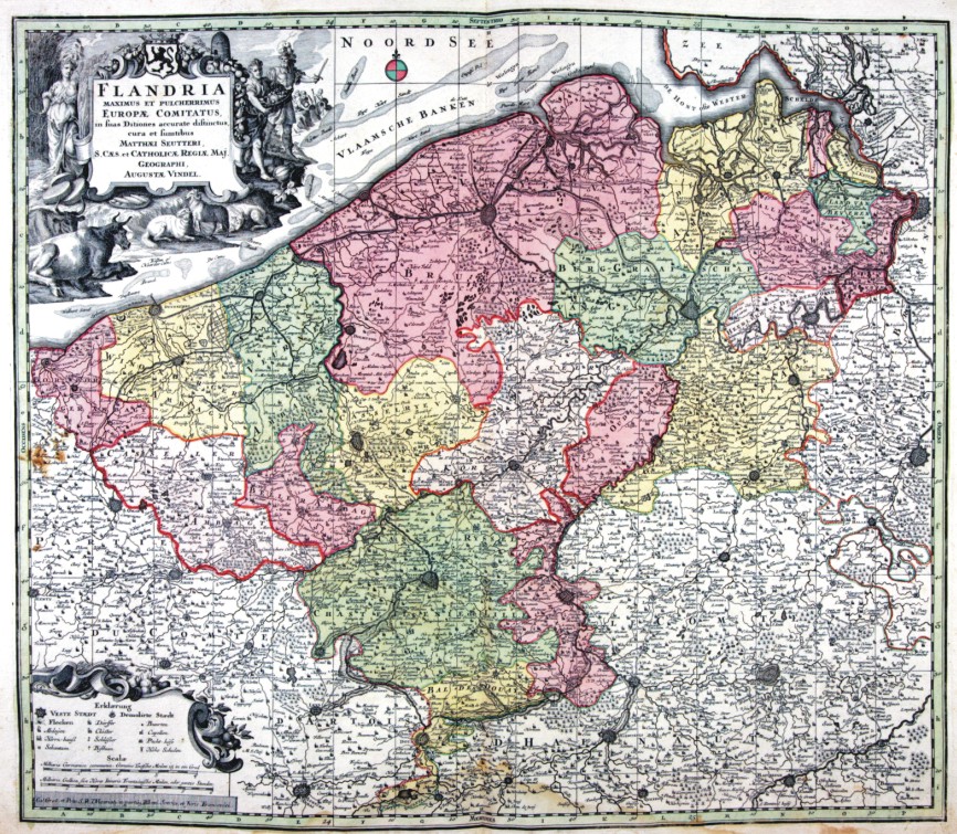
464-FLANDRIA .
The map (cm 52,5 x 70,0), which is contained in the collection of cards Matthäus Seutter entitled Sphaerae artificiales of 1730, was printed in Augsburg in the publishing house of Jeremias Wolff. Cartouche in the upper right corner shows the title Italia secundum observationes Societatis Regiae Scientiarum quae est Parisiis nec non R.P.Riccioli Societatis Iesu aliorumque Astronomorum et diversorum Memorialium concinnata Per G. De L’Isle Geog.Parisiensem prostat nunc in Officina Ierem.Wolfii. Author: Matthäus Seutter
Augusta,1730 |
|
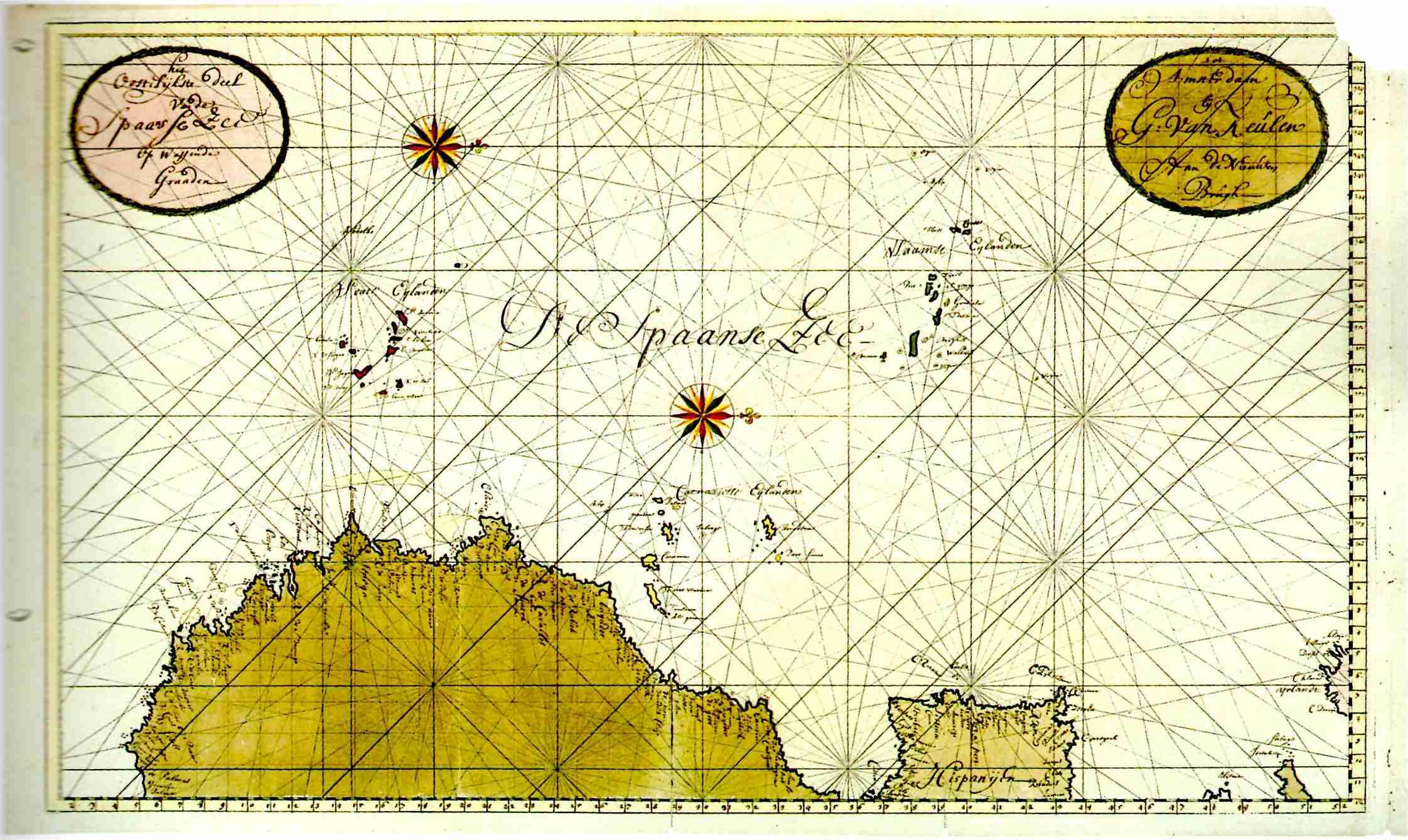
683-Atlantico Orientale dall' Irlanda a Capo Palmas .
Author: Gerard van Keulen
Amsterdam,0 |
|
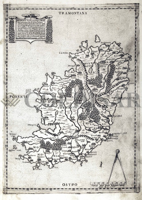
745 - Hibernia .
Author: Paolo Forlani
Venezia,1565 |
|
746 - Corfù .
Author: Ferdinando Bertelli
Venezia,1564 |
|
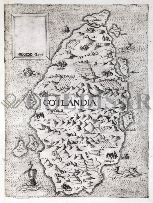
748 - Gotlandia .
Author: Ferdinando Bertelli
,1550 |
|
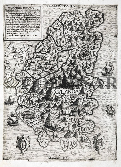
749 - De Islanda Insula .
Author: Ferdinando Bertelli
Venezia,1566 |
|
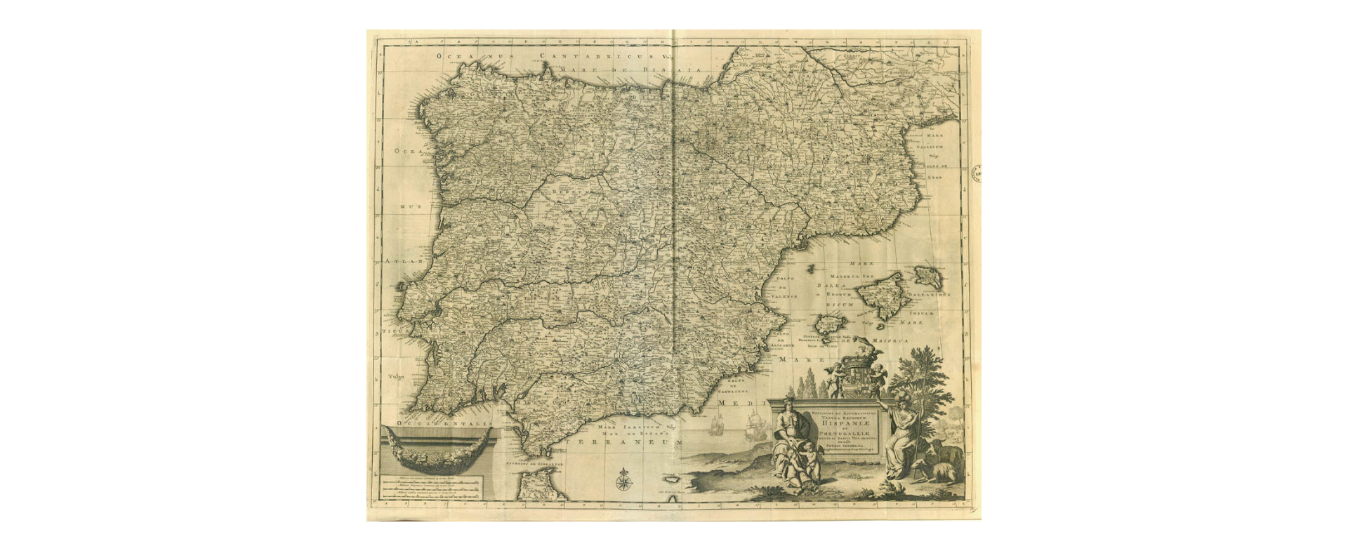
860-Hispaniae et Portugalliae .
Author: Pieter Van Der Aa
,1729 |
|
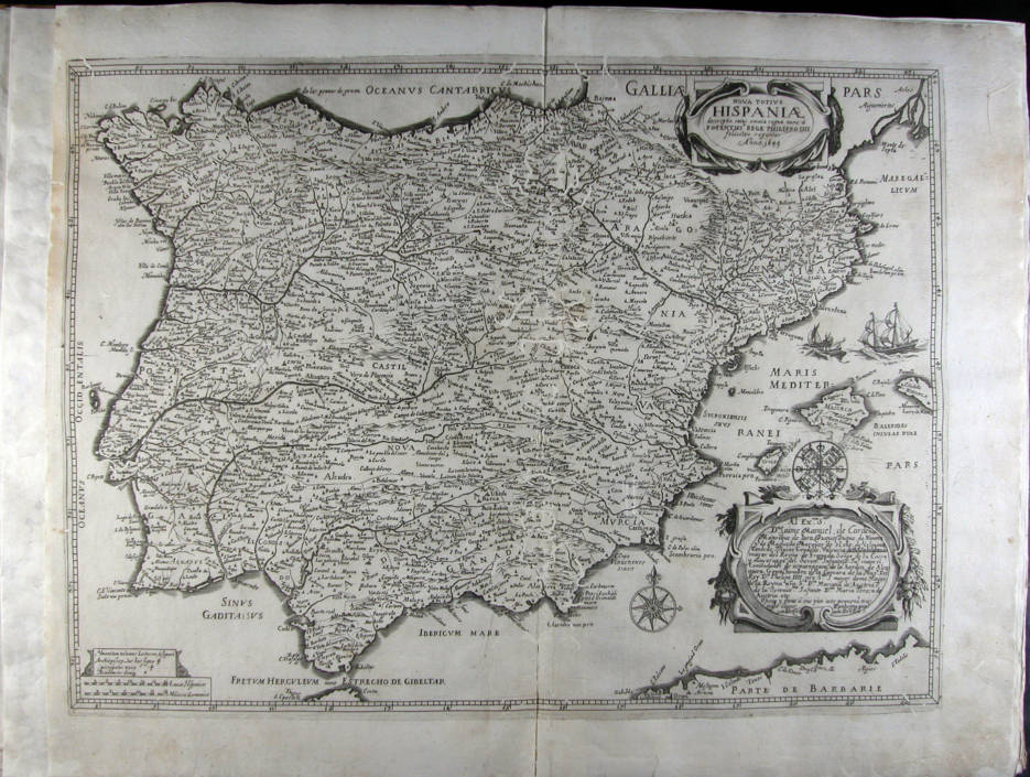
827-Nova totius Hispaniae descriptio, cuius omnia regna nunc à Potnetissº rege Philippo .
Author:
,1649 |
|
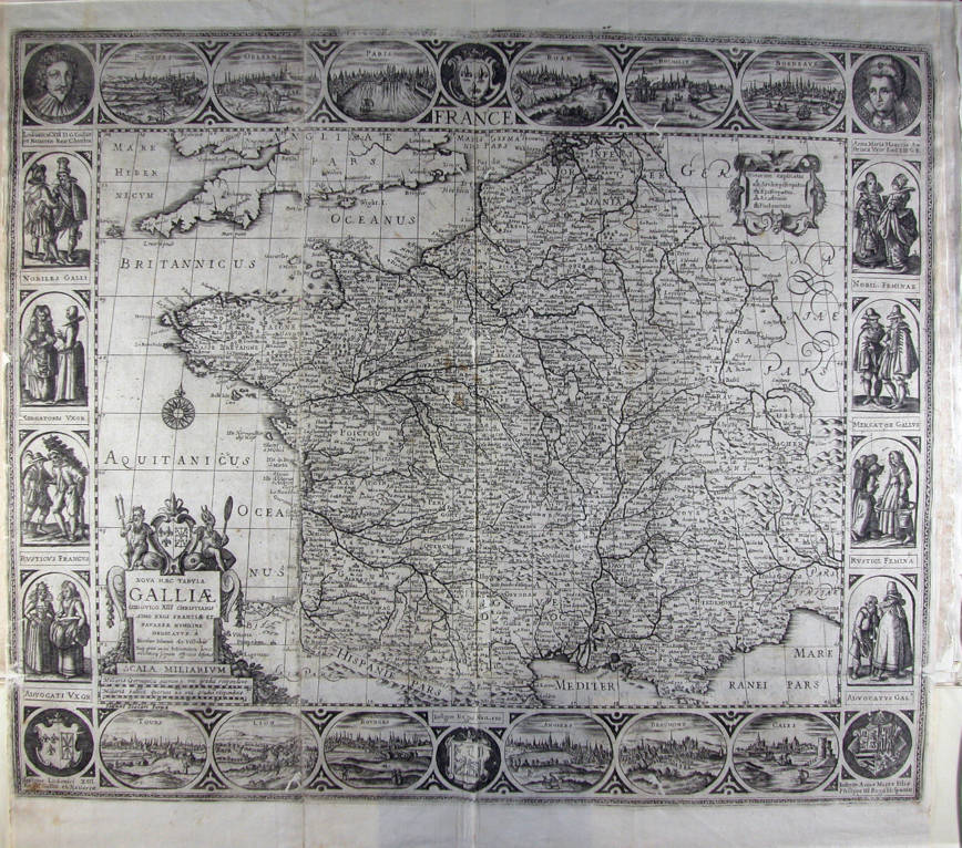
826-Nova haec tabula Galliae Lodovico XIII christianissimo regi Franciae et Navarrae humil .
Author: Visscher
,0 |
|
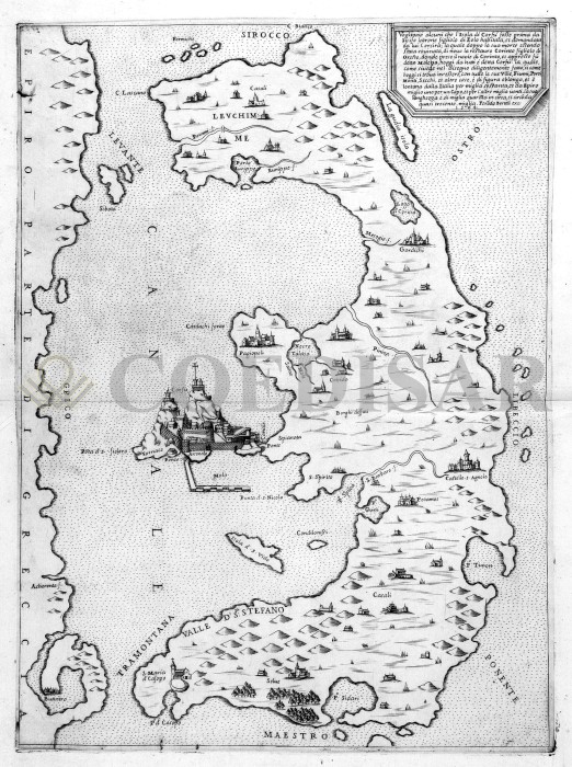
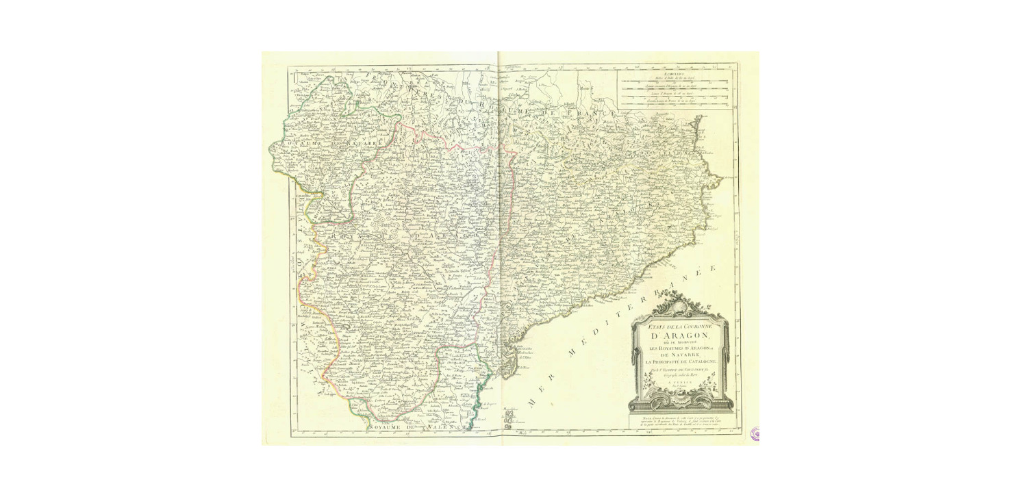
874- Etats de la Couronne d'Aragon .
Author: Paolo Santini, Robert de Vaugondy
,1776 |
|
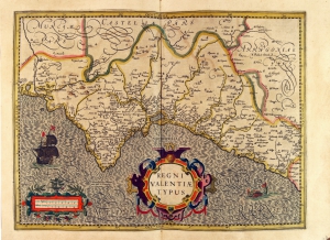
775-Regni Valencia Tipus .
Author: Gerardo Mercatore
Amsterdam,1638 |
|
768-Insulae Balearides et Pytiusae .
Author: Johannes Janssonius
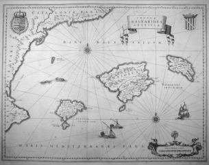
Amsterdam,1642 |
|
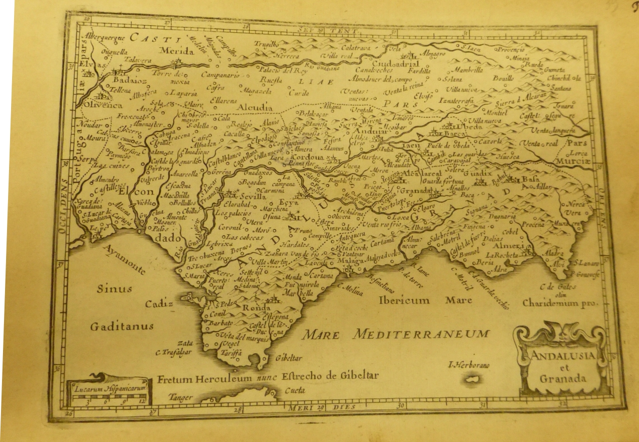
971-Andalusia e Granada .
Author:
,0 |
|
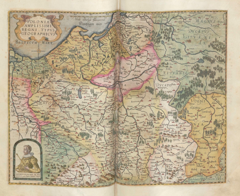
1004-Poloniae amplissimi regni typus geographicus .
Author: Gerardus de Judaeis
Anversa,1593 |
|
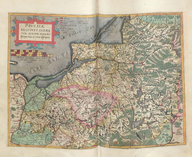
1005-Prussiae Regionis Sarmatiae Europae Nobibilis simae nova et vera descriptio .
Author: Gerardus de Judaeis
Anversa,1593 |
|
1006-Silesia Ducatus Typice descriptus per [and] Ductaus Oswieczime et Zatoriesis descript .
Author: Gerardus de Judaeis
Anversa,1578 |

|
1008-Utriusque .
Author: Frederick de Wit
,0 |
