![]()
![]()
![]()
![]()
![]()
![]()


MY MAPS
Regions:
![]()
Browse the website:
Latest Acquisitions
A Brief History of Cartography
The Cartographers
Events on ancient maps
Accimo editions
Brochure MB
Contacts
Glossary
Sitemap
|
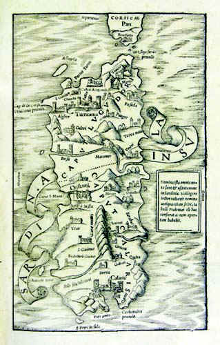
Sardinia Insula Description: The map resides in Sebastiano Munster's atlas Cosmographiae universalis - Libri VI , edition released in 1554. It was taken from a woodcut and measures 25,5 x 15,5cm. In 1550 this atlas was published for the first time in latin. The document has no scale, parallels, meridians and it is not graduated in the margins. But we can see the cardinal points Occidens, Septentrio,Oriens, the South is missing. Autor: Sigismondo Arquer Place: Basilea Year: 1554 Quality document:
See online :
Go to verification |

See the printed version: Click here
