![]()
![]()
![]()
![]()
![]()
![]()


MY MAPS
Regions:
![]()
Browse the website:
Latest Acquisitions
A Brief History of Cartography
The Cartographers
Events on ancient maps
Accimo editions
Brochure MB
Contacts
Glossary
Sitemap
7 results
|
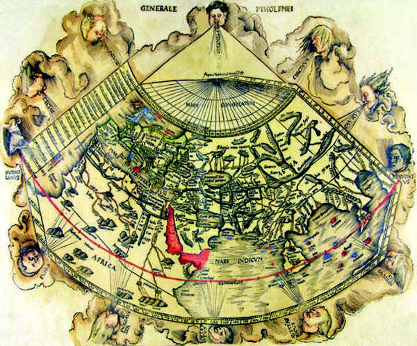
35-Carta del Mondo .
The map belongs to table 2 of the atlas Ptolomeus Auctus restitutus et maculatus cum tabulis veteribus ac novis. Typis Joannis Scoti . It contains very beautiful documents.This ecumenic planiphere summarizes the antique geographic knowledges. Author: Claudio Tolomeo
Strasburgo. ,1520 |
|
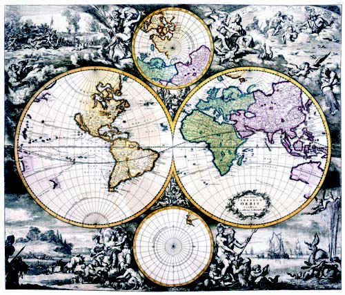
36-Terrarum Orbis .
The map belongs to the Atlas de la Navigation et du Commerce qui se fait dans toutes les Parties du Monde and was printed in 1715 in Amsterdam chez Louis Renard, Marchant libraire. It's one of the best atlas of the 18th century. The planisphere is colored and measures 48,5 x 57 cm. It's very finely engraved and decorated with representations of mythological scenes, seamonsters, scenes of country and warlife. Framed it will have a big effect. Very interesting map for amateurs of antique geography. Author: Louis Renard
Amsterdam ,1715 |
|
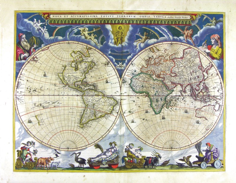
37-Nova et Accuratissima Totius Terrarum Orbis Tabula .
The map is part of the atlas Geographia, quae is Cosmographiae Blauianae pars prima, qua orbisterrae tabulis ante oculus ponitus et descriptionibus illustratur di Ioannis Blaeu. It was printed in 1665 in Amsterdam. The world map is richly ornamented with mythological figures and exotic. Dimensions: 53.5 x 40 cm
Author: Ioannis Blaeu
Amsterdam,1665 |
|
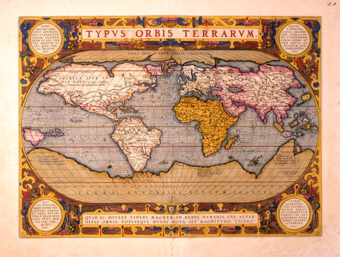
38-Typus Orbis Terrarum .
This planisphere, printed in the 16 th century in the Blaeu workshop in Amsterdam shows some differences from the Blaeu edition of 1662. Author: Abramo Ortelio
Amsterdam. ,1665 |
|
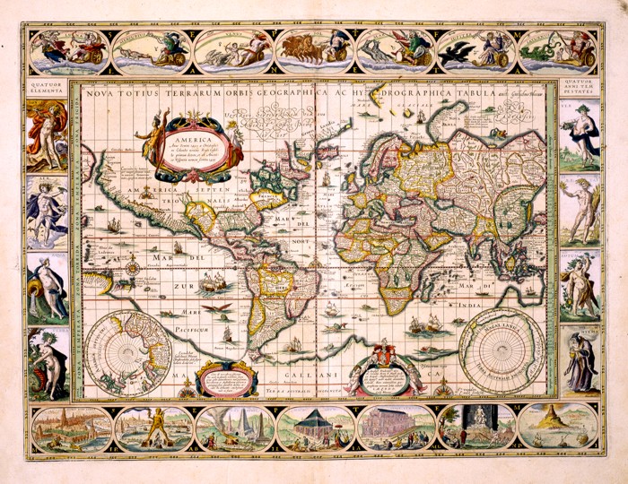
Nova Totius Terrarum Oorbis Geographica ac Hydrographica Tabula .
This finely-executed map shows splendid mythological figures, the moon and the planets at the top, the four elements of Nature on the left, the four Seasons on the right and the seven Wonders of the World at the bottom. There also are three pictures, a wind rose, the poles, several sailing vessels and sea monsters. The drawing of this map measures 54 x 41 cm and the borders 7,5 cm. It comes from an atlas of the 17th century, probably printed in 1630 in the Blaeu workshop in Amsterdam. Author: Ioannis Blaeu
Amsterdam,1630 |
|
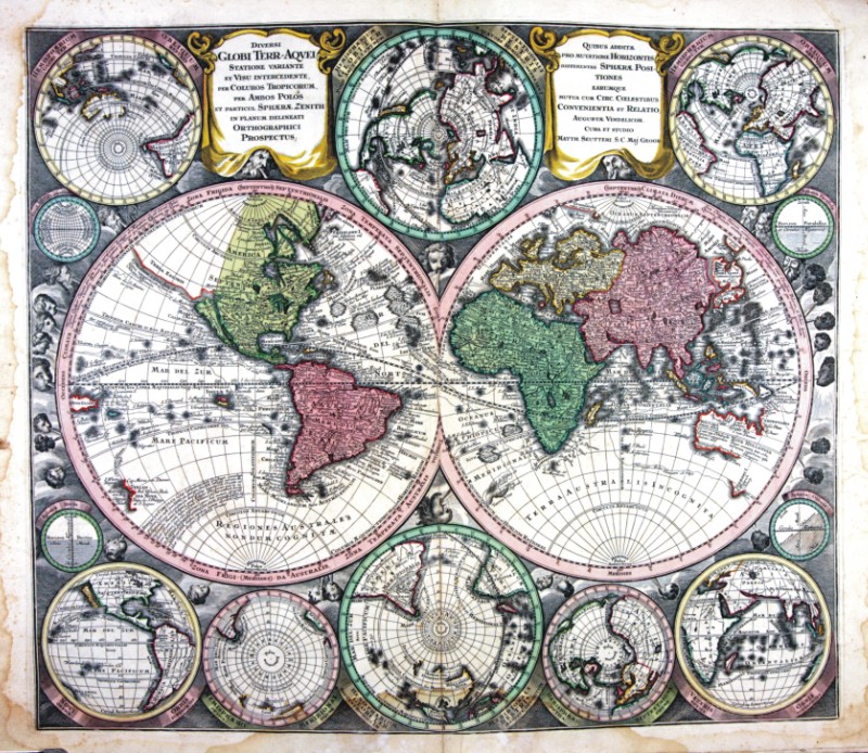
458-Globi Terr-Aqvei .
The map (cm 52,5 x 70,0), which is contained in the collection of cards Matthäus Seutter entitled Sphaerae artificiales of 1730, was printed in Augsburg in the publishing house of Jeremias Wolff. Cartouche in the upper right corner shows the title Italia secundum observationes Societatis Regiae Scientiarum quae est Parisiis nec non R.P.Riccioli Societatis Iesu aliorumque Astronomorum et diversorum Memorialium concinnata Per G. De L’Isle Geog.Parisiensem prostat nunc in Officina Ierem.Wolfii. Author: Seutter
Augusta,1730 |
|
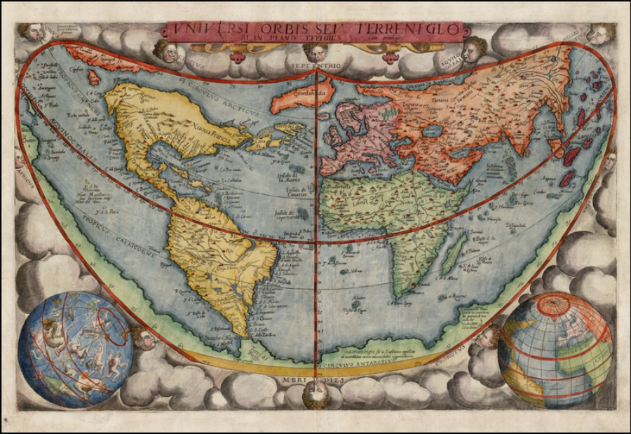
995-Universi Orbis Sev Terreni Glob .
Author: Gerardus de Judaeis
Anversa,1593 |
