![]()
![]()
![]()
![]()
![]()
![]()


MY MAPS
Regions:
![]()
Browse the website:
Latest Acquisitions
A Brief History of Cartography
The Cartographers
Events on ancient maps
Accimo editions
Brochure MB
Contacts
Glossary
Sitemap
|
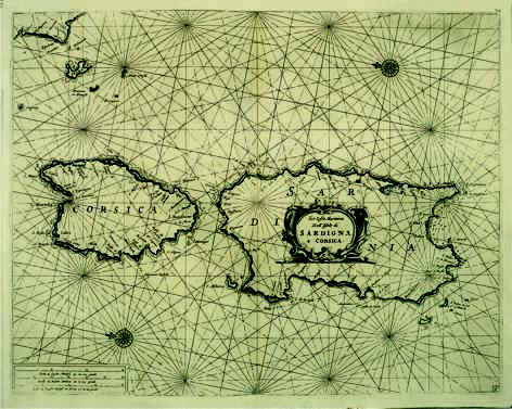
103-Le Coste Marittime delle Isole di Sardegna e Corsica Description: The map belongs to the atlas Prima parte dello Specchio del Mare published in 1664 in Genoa by F.M. Levanto. It was taken from a copper plate engraving and proposes a sector of the Mediterranean Sea with Sardinia, Corsica, Elba and other small Islands of the Tuscan Archipelago and the Promontory of Piombino. Autor: Francesco Maria Levanto Place: Genova Year: 1664 Quality document: Ottima
See online :
Go to verification |

See the printed version: Click here
