![]()
![]()
![]()
![]()
![]()
![]()


MY MAPS
Regions:
![]()
Browse the website:
Latest Acquisitions
A Brief History of Cartography
The Cartographers
Events on ancient maps
Accimo editions
Brochure MB
Contacts
Glossary
Sitemap
|
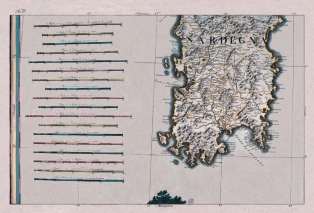
648-Sardegna centrale e meridionale Description: The map, that center-southern Sardinia represents, as the preceding one is in the volume Theater of the War, it is the n. 10 of the harvest and it belongs to the edition of the General Paper of Italy it dates to the presses in the typography of Anthony Zatta in the 1798. The document derives from an incision in copper, it is color acquerellato, introduces aloft the North, measure cm 64,3 xes 41,8 and in the sketch cm 61,4 xes 386. Of this paper another edition is known, in black and white of which the author is not known, that has done reference to the paper called of the Ingenieurses Piemontois published by her Rouge in 1753 for the realization; from this last you/he/she has proposed the simbologia and line the divisions of the feudal districts. The writing Sardinia is set in the tall part of the sketch, the left border is graduated, and introduces a sweaters grid trapezoidal. On the left side they are present well 18 graphic staircases that pointed out the unities of measure of the principals been Italian and European. Autor: Antonio Zatta Place: Livorno Year: 1788 Quality document: A+
See online :
Go to verification |

See the printed version: Click here
