![]()
![]()
![]()
![]()
![]()
![]()


MY MAPS
Regions:
![]()
Browse the website:
Latest Acquisitions
A Brief History of Cartography
The Cartographers
Events on ancient maps
Accimo editions
Brochure MB
Contacts
Glossary
Sitemap
|
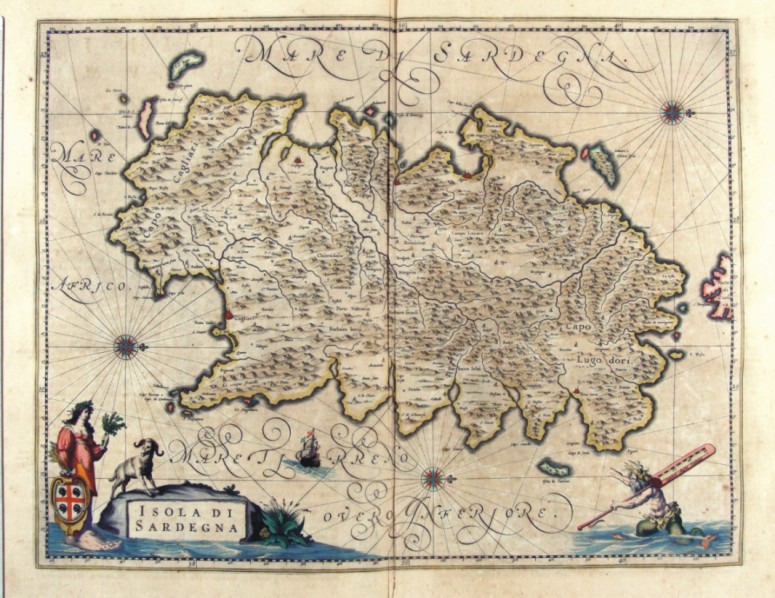
296-Isola di Sardegna Description: The map of Sardinia, painted in water colours, has the West at the top, the North with a lily on the right and three wind roses over the sea. The more important towns like Cagliari, Oristagni, Bosa città , Algeri (Alghero), C. Aragonese (Castelsardo) and Terra Nuova (Olbia) are indicated with red perspective drawings, however the smaller places have just a little circle. The Gulf of Cagliari and the Gulf of Teulada are in the South, the Isola Rossa is indicated with a beautiful red colour. The islands of the Sulcis territory are correctly placed in the South West, Zamara o Asinara Isola, the Isola Piana and the Promontory of Monte Falco are in the North West, a non-existing group of islands (Isole Sanguinari), Serpentara and I Cavoli are in the South East. A wonderful picture of an allegoric figure holding the blazon of the island (a shield with a red cross and four black Moors with a frontlet), includes the title. The figure is drawn with a large human foot refering to the Greek name of Sardinia Sandaliotis. On the bottom right a mythological figure over the sea holds a graduated scale of fifteen Italian miles on its shoulder. Measuring 38 x 49,5 cm, this map comes from the atlas Geographiae Blavianae volumen octavum quo Italia quae est Europae liber sextus, continetur Amstelodami, Labore & Sumptibus Joannis Blaeu MDCLXII, printed in 1662 in Amsterdam. Autor: Ioannis Blaeu Place: Amsterdam Year: 1662 Quality document:
See online :
Go to verification |

See the printed version: Click here
