![]()
![]()
![]()
![]()
![]()
![]()


MY MAPS
Regions:
![]()
Browse the website:
Latest Acquisitions
A Brief History of Cartography
The Cartographers
Events on ancient maps
Accimo editions
Brochure MB
Contacts
Glossary
Sitemap
|
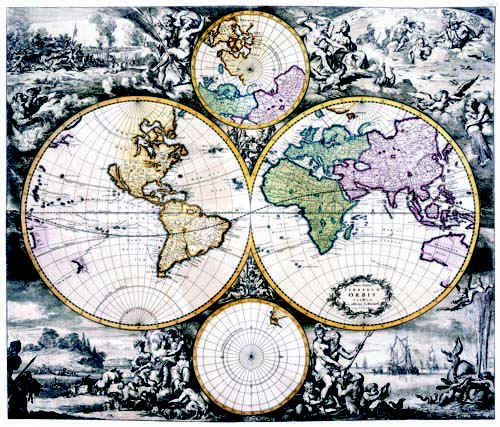
36-Terrarum Orbis Description: The map belongs to the Atlas de la Navigation et du Commerce qui se fait dans toutes les Parties du Monde and was printed in 1715 in Amsterdam chez Louis Renard, Marchant libraire. It's one of the best atlas of the 18th century. The planisphere is colored and measures 48,5 x 57 cm. It's very finely engraved and decorated with representations of mythological scenes, seamonsters, scenes of country and warlife. Framed it will have a big effect. Very interesting map for amateurs of antique geography. Autor: Louis Renard Place: Amsterdam Year: 1715 Quality document:
See online :
Go to verification |

See the printed version: Click here
