![]()
![]()
![]()
![]()
![]()
![]()


MY MAPS
Regions:
![]()
Browse the website:
Latest Acquisitions
A Brief History of Cartography
The Cartographers
Events on ancient maps
Accimo editions
Brochure MB
Contacts
Glossary
Sitemap
|
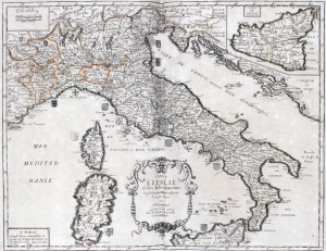
501-Carte de l'Italie et des Isles adjacentes Description: This map, measuring 37 x 48 cm and drawn by Pierre du Val, was printed in 1663 in Paris. It is a splendid coloured document coming from a fine engraving of I. Lhuilier. It shows an exact subdivision of the Italian states and dukedoms with their blazons at that time. Sicily appears in a square on the top right. In the centre-bottom is a beautiful title picture; on the top left are the graphic scales in Lieues communes de Fra(n)ce; Milles d'Italie. Autor: Pierre Du Val Place: Parigi Year: 1663 Quality document:
See online :
Go to verification |

