![]()
![]()
![]()
![]()
![]()
![]()


MY MAPS
Regions:
![]()
Browse the website:
Latest Acquisitions
A Brief History of Cartography
The Cartographers
Events on ancient maps
Accimo editions
Brochure MB
Contacts
Glossary
Sitemap
|
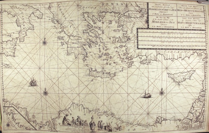
397-Grecia Van Keulen Description: This map comes from the Ioannes van Keulen atlas Zee-Atlas ofte Water Waereld, printed in 1706 in Amsterdam. Measuring 59 x 94 cm , it shows the Eastern basin of the Mediterranean Sea. The title, written in Dutch, French, English and Italian appears on the top left, just above a square containing five graphic scales in Dutch and Italian miles, in English, French and Spanish leagues. At the bottom, along the Libyan Coasts, a square surrounded by figures of European and Saracen merchants, includes the author's indication Amsterdam by Ioannes van Keulen. There is another square showing the Eastern part of the Tunisian Coasts and the Island of Gerba on the bottom left. This graduated map is executed with several wind roses, but only three of them are visible. Some figures are drawn on the Libyan Coasts and two ships are at sea. Autor: Van Keulen Place: Amsterdam Year: 1706 Quality document:
See online :
Go to verification |

