![]()
![]()
![]()
![]()
![]()
![]()


MY MAPS
Regions:
![]()
Browse the website:
Latest Acquisitions
A Brief History of Cartography
The Cartographers
Events on ancient maps
Accimo editions
Brochure MB
Contacts
Glossary
Sitemap
|
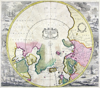
34-Poli Artici Description: The map belongs to the Atlas de la Navigation et du Commerce qui se fait dans toutes les Parties du Monde, published in 1715 in Amsterdam. taken from a fine engraving and decorated with a lot of drawings. Dimensions: 48,6 x 43 cm Autor: Louis Renard Place: Amsterdam Year: 1715 Quality document:
See online :
Go to verification |

